Gainesville, Missouri facts for kids
Quick facts for kids
Gainesville, Missouri
|
|
|---|---|

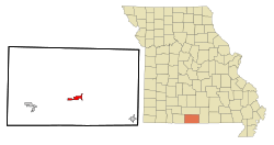
Location of Gainesville, Missouri
|
|
| Country | United States |
| State | Missouri |
| County | Ozark |
| Area | |
| • Total | 2.87 sq mi (7.44 km2) |
| • Land | 2.87 sq mi (7.44 km2) |
| • Water | 0.00 sq mi (0.00 km2) |
| Elevation | 781 ft (238 m) |
| Population
(2020)
|
|
| • Total | 745 |
| • Density | 259.49/sq mi (100.19/km2) |
| Time zone | UTC-6 (Central (CST)) |
| • Summer (DST) | UTC-5 (CDT) |
| ZIP code |
65655
|
| Area code(s) | 417 |
| FIPS code | 29-26218 |
| GNIS feature ID | 0718308 |
Gainesville is a small city located in Ozark County, Missouri, in the United States. It's known as the county seat of Ozark County, which means it's where the main government offices for the county are. In 2020, about 745 people lived here.
Contents
History of Gainesville
Gainesville was first planned out in 1841. It got its name from Gainesville, Georgia, because many of the first people who settled here came from that place. In 1857, Gainesville was chosen to be the main town, or county seat, for Ozark County. A post office has been open in Gainesville since 1860.
Where is Gainesville Located?
Gainesville is found where two main roads meet: U.S. Route 160 and Missouri Route 5. It sits in the Lick Creek valley, which is a low area between hills. Another road, Route 181, also starts near the east side of town. The city covers an area of about 2.87 square miles (7.44 square kilometers), and it's all land.
Population of Gainesville
The number of people living in Gainesville has changed over the years. Here's how the population has grown and shrunk since 1880:
| Historical population | |||
|---|---|---|---|
| Census | Pop. | %± | |
| 1880 | 165 | — | |
| 1890 | 175 | 6.1% | |
| 1900 | 222 | 26.9% | |
| 1910 | 195 | −12.2% | |
| 1920 | 256 | 31.3% | |
| 1930 | 235 | −8.2% | |
| 1940 | 255 | 8.5% | |
| 1950 | 309 | 21.2% | |
| 1960 | 266 | −13.9% | |
| 1970 | 627 | 135.7% | |
| 1980 | 707 | 12.8% | |
| 1990 | 659 | −6.8% | |
| 2000 | 632 | −4.1% | |
| 2010 | 773 | 22.3% | |
| 2020 | 745 | −3.6% | |
| U.S. Decennial Census | |||
What the 2010 Census Showed
In 2010, there were 773 people living in Gainesville. These people lived in 356 homes, and 204 of those homes were families. The city had about 269 people per square mile. Most of the people (96.51%) were White. A small number were Native American or from other backgrounds. About 1.68% of the population was Hispanic or Latino.
Many homes (28.1%) had children under 18 living there. About 41.3% were married couples. Some homes (40.4%) had just one person living there. The average age of people in Gainesville was 42.6 years old.
Education in Gainesville
Students in Gainesville go to public schools managed by the Gainesville R-5 School District. The school campus is 61 acres big. It includes the high school, which was built in 1962, a junior high wing added in 1971, and a new elementary school finished in 1995.
The school district covers a large area of 339 square miles. It serves students from Gainesville and nearby rural communities like Thornfield, Wasola, Tecumseh, and Pontiac. The Gainesville R-V School District is "fully accredited," which means it meets high standards. It also has an A+ designation.
See also
 In Spanish: Gainesville (Misuri) para niños
 | Valerie Thomas |
 | Frederick McKinley Jones |
 | George Edward Alcorn Jr. |
 | Thomas Mensah |

