Hammond, Missouri facts for kids
Quick facts for kids
Hammond, Missouri
|
|
|---|---|
|
Community
|
|

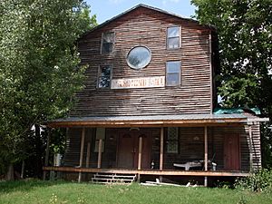
The old Hammond Mill building in Ozark County, Missouri
|
|
| Country | U. S. A. |
| State | Missouri |
| County | Ozark County |
| Elevation | 227 m (745 ft) |
| Time zone | UTC-6 (CST) |
| • Summer (DST) | UTC-5 (CDT) |
Hammond is a small, unincorporated community in Ozark County, Missouri. An unincorporated community means it's not a city or town with its own local government. It is located where two county roads meet. This spot is right on the Little North Fork of the White River. Hammond is about twelve miles northwest of Gainesville. It is also about 2.5 miles southeast of Thornfield.
Contents
Exploring Hammond, Missouri
The Story Behind the Name
A post office opened in Hammond in 1894. It stayed open for many years, finally closing in 1975. People have different ideas about how Hammond got its name. Some believe it was named after the local Hammond family. They might have been the first owners of the land where the community is. Others think the reason for the name "Hammond" is still a mystery.
The Historic Hammond Mill
Hammond is well-known for its historic mill. The Hammond Mill was built in 1907. It worked as a gristmill until around 1940. A gristmill is a place where grain is ground into flour. After its milling days, the building was restored. Today, it is used as a private home.
Where is Hammond Located?
The community of Hammond sits on the northeast side of a wide stream floodplain. A floodplain is a flat area of land next to a river. This floodplain is about 1,300 feet wide. Hammond is at an elevation of 744 feet. This is about 200 feet below the nearby hilltops.
 | Selma Burke |
 | Pauline Powell Burns |
 | Frederick J. Brown |
 | Robert Blackburn |


