Rockbridge, Missouri facts for kids
Quick facts for kids
Rockbridge, Missouri
|
|
|---|---|
|
Community
|
|

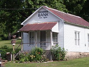
The old bank building at Rockbridge
|
|
| Country | U. S. A. |
| State | Missouri |
| County | Ozark County |
| Elevation | 230 m (750 ft) |
| Time zone | UTC-6 (CST) |
| • Summer (DST) | UTC-5 (CDT) |
| Zip Code |
65741
|
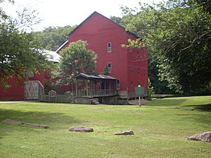
Rockbridge is a small, unincorporated community in Ozark County, Missouri. It's famous for its historic mill, which sits right on Spring Creek. This creek is fed by natural springs and flows into Bryant Creek. The old mill building still holds the local post office!
Contents
Exploring Rockbridge's Location
Rockbridge is about 12 miles (19 km) north of Gainesville. You can find it near Missouri Route N and Route 95. The valley where Rockbridge is located is quite narrow. It's about 650 feet (198 meters) wide. The hills around it are part of the Ozark Mountains and rise much higher.
A Look at Rockbridge's Past
Rockbridge was started in the 1800s by pioneer families. They were led by Captain Kim Amyx. During the American Civil War, the community was burned down. But after the war, people rebuilt it. A post office has been open in Rockbridge since 1842. The community got its name from a natural rock crossing near a spring.
Rockbridge was once a very important place. It used to be the main town, or county seat, for a much larger Ozark County. This bigger county included parts of what are now Douglas and Howell counties.
Amazing Natural Springs
Rockbridge is in a karst region. This means the area has many caves, springs, and natural stone bridges. Four different springs feed the mill's pool. Another spring, Morris Spring, forms a small pool near the road. These springs are quite powerful! The Rockbridge Spring flows at about 19 cubic feet (0.54 cubic meters) per second. Morris Spring flows at about 3.6 cubic feet (0.1 cubic meters) per second. The water from these springs comes from where the Roubidoux sandstone meets the Gasconade dolomite rock layers underground.
Today, the community is owned by the Rainbow Trout & Game Ranch and Rockbridge Gun Club. This place was started in 1954. It even has a trout fish hatchery where they raise fish! About five miles (8 km) northwest, you can find Assumption Abbey. This is a Trappist monastery located above the Bryant Creek floodplain.
The Historic Rockbridge Road
Rockbridge was a key stop along the old Rockbridge Road. This road was also called the Rockbridge–Springfield Road. It was built before the Civil War. It was used to transport goods between Arkansas and Springfield. At first, wagons pulled by ox teams carried pine lumber from Arkansas sawmills to Springfield. After the railroad came to Springfield, the road was used to haul cotton. Mule teams carried cotton from northeast Arkansas to Springfield until after the Civil War.
 | James Van Der Zee |
 | Alma Thomas |
 | Ellis Wilson |
 | Margaret Taylor-Burroughs |


