
Newton County, Arkansas facts for kids
Quick facts for kids
Newton County
|
|
|---|---|
  _003.jpg)   Clockwise from top: Boxley Valley, Hawksbill Crag, the Ozark Mountains in the Upper Buffalo Wilderness, Twin/Triple Falls at Camp Orr Boy Scout Camp, and the Newton County Courthouse in Jasper (center)
|
|

Location within the U.S. state of Arkansas
|
|
 Arkansas's location within the U.S. |
|
| Country | |
| State | |
| Founded | December 14, 1842 |
| Named for | Thomas Willoughby Newton |
| Seat | Jasper |
| Largest city | Jasper |
| Area | |
| • Total | 823 sq mi (2,130 km2) |
| • Land | 821 sq mi (2,130 km2) |
| • Water | 2.3 sq mi (6 km2) 0.3%% |
| Population
(2020)
|
|
| • Total | 7,225 |
| • Density | 8.779/sq mi (3.3895/km2) |
| Time zone | UTC−6 (Central) |
| • Summer (DST) | UTC−5 (CDT) |
| Congressional district | 4th |
Newton County is a county located in the state of Arkansas, USA. In 2020, about 7,225 people lived there. The main town and county seat is Jasper. Newton County became Arkansas's 46th county on December 14, 1842. It was named after Thomas Willoughby Newton, who was a Congressman from Arkansas.
Newton County is also part of the Harrison, AR area.
Contents
A Look Back: History of Newton County
During the American Civil War, people in Newton County had different ideas. Some joined the Confederate army, and others joined the Union army. For example, John Cecil, who used to be the sheriff, became a Confederate Captain.
On the other side, James R. Vanderpool, a blacksmith from Jasper, became a Captain for the Union army. John McCoy, a farmer and teacher, also led a Union company. Many local people served under these leaders.
The war even divided families. Captain Cecil's brother, Sam, fought for the Union. The fighting was very hard on the people living there. At one point, Captains McCoy and Vanderpool helped 20 wagons of Union-supporting families move to Missouri to find safety.
Exploring the Land: Geography

Newton County covers about 823 square miles (2,130 square kilometers). Most of this area is land, with only a small part being water.
The county is mostly within the Boston Mountains, which are part of the Ozark Mountains. Here, the land is rugged, and some spots are over 2,500 feet (760 meters) high. The Buffalo National River flows through the county from west to east. This river is a popular place for canoeing and other fun activities.
Highway 7 goes through the county from north to south. Many people think it's one of the most beautiful drives in the country!
Neighboring Counties
Newton County shares its borders with several other counties:
- Boone County (to the north)
- Searcy County (to the east)
- Pope County (to the southeast)
- Johnson County (to the south)
- Madison County (to the west)
- Carroll County (to the northwest)
Protected Natural Areas
Newton County is home to parts of some important natural areas:
- Buffalo National River
- Ozark National Forest
- Upper Buffalo Wilderness
- Mystic Cavern
Who Lives Here: Population Facts
Newton County has seen its population change over the years. In 1850, there were about 1,758 people. The population grew a lot by 1900, reaching over 12,500.
By 2020, the population was 7,225 people. Most residents are White. There are also smaller numbers of Native American, Asian, Black, and other groups. About 1.13% of the population is of Hispanic or Latino background.
Fun Things to Do: Attractions
One exciting event in Newton County is the 24 Hours of Horseshoe Hell (24HHH). This is an annual rock-climbing competition held at Horseshoe Canyon Ranch. Teams of two climbers try to climb as many routes as they can in 24 hours!
The canyon walls are made of sandstone and have over 411 climbing routes. This event started in 2006. Climbing magazine has called it one of the toughest endurance events in the country.
Local Places: Communities
Newton County has one city, one town, and several smaller communities.
City
- Jasper (This is the county seat, where the main government offices are.)
Town
Census-Designated Places
These are areas that are like towns but are not officially incorporated:
Other Small Communities
Getting Around: Major Highways
Several important highways run through Newton County, helping people travel and connect to other areas:
 U.S. Highway 65
 Arkansas Highway 7
 Arkansas Highway 16
 Arkansas Highway 21
 Arkansas Highway 43
 Arkansas Highway 74
 Arkansas Highway 123
Images for kids
-
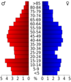
Age pyramid for Newton County
-
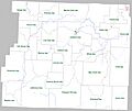
Map showing townships in Newton County, Arkansas


See also
 In Spanish: Condado de Newton (Arkansas) para niños
