Johnson County, Arkansas facts for kids
Quick facts for kids
Johnson County
|
|
|---|---|

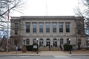
Courthouse in Clarksville
|
|

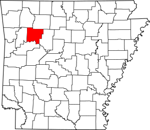
Location within the U.S. state of Arkansas
|
|
 Arkansas's location within the U.S. |
|
| Country | |
| State | |
| Founded | November 16, 1833 |
| Seat | Clarksville |
| Largest city | Clarksville |
| Area | |
| • Total | 683 sq mi (1,770 km2) |
| • Land | 660 sq mi (1,700 km2) |
| • Water | 23 sq mi (60 km2) 3.4%% |
| Population
(2020)
|
|
| • Total | 25,749 |
| • Estimate
(2023)
|
25,845 |
| • Density | 37.700/sq mi (14.556/km2) |
| Time zone | UTC−6 (Central) |
| • Summer (DST) | UTC−5 (CDT) |
| Congressional district | 4th |
Johnson County is a county located in the state of Arkansas, USA. It's like a large district or region within the state. As of the 2020 census, about 25,749 people lived here. The main town, or county seat, is Clarksville. Johnson County became Arkansas's 30th county on November 16, 1833. It was named after Benjamin Johnson, who was an important judge in the Arkansas Territory a long time ago.
Contents
Geography of Johnson County
Johnson County covers a total area of about 683 square miles. Most of this area, about 660 square miles, is land. The remaining 23 square miles, which is about 3.4% of the county, is covered by water.
Main Roads
These are the major roads that pass through Johnson County:
 Interstate 40
 U.S. Route 64
 Arkansas Highway 21
 Arkansas Highway 103
 Arkansas Highway 109
 Arkansas Highway 123
Neighboring Counties
Johnson County shares its borders with several other counties:
- Newton County (to the north)
- Pope County (to the east)
- Logan County (to the south)
- Franklin County (to the west)
- Madison County (to the northwest)
Protected Natural Areas
A part of the Ozark National Forest is located within Johnson County. This is a large area of protected land with forests and natural beauty.
Population and People
| Historical population | |||
|---|---|---|---|
| Census | Pop. | %± | |
| 1840 | 3,433 | — | |
| 1850 | 5,227 | 52.3% | |
| 1860 | 7,612 | 45.6% | |
| 1870 | 9,152 | 20.2% | |
| 1880 | 11,565 | 26.4% | |
| 1890 | 16,758 | 44.9% | |
| 1900 | 17,448 | 4.1% | |
| 1910 | 19,698 | 12.9% | |
| 1920 | 21,062 | 6.9% | |
| 1930 | 19,289 | −8.4% | |
| 1940 | 18,795 | −2.6% | |
| 1950 | 16,138 | −14.1% | |
| 1960 | 12,421 | −23.0% | |
| 1970 | 13,630 | 9.7% | |
| 1980 | 17,423 | 27.8% | |
| 1990 | 18,221 | 4.6% | |
| 2000 | 22,781 | 25.0% | |
| 2010 | 25,540 | 12.1% | |
| 2020 | 25,749 | 0.8% | |
| 2023 (est.) | 26,129 | 2.3% | |
| U.S. Decennial Census 1790–1960 1900–1990 1990–2000 2010 2020-2021 |
|||
Population in 2020
According to the 2020 United States census, Johnson County had 25,749 people living in 9,792 households.
Different Backgrounds
The people in Johnson County come from many different backgrounds. In 2020, about 75.34% of the population was White (not Hispanic). About 1.76% were Black or African American, and 0.78% were Native American. Around 3.57% of the people were Asian, and 0.1% were Pacific Islander. About 5.08% of the population identified as Other or Mixed races. Additionally, about 13.36% of the people were of Hispanic or Latino background.
See also
 In Spanish: Condado de Johnson (Arkansas) para niños
 | Percy Lavon Julian |
 | Katherine Johnson |
 | George Washington Carver |
 | Annie Easley |


