Stone County, Arkansas facts for kids
Quick facts for kids
Stone County
|
|
|---|---|
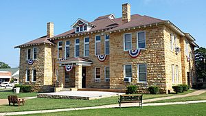
Stone County courthouse in Mountain View
|
|
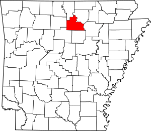
Location within the U.S. state of Arkansas
|
|
 Arkansas's location within the U.S. |
|
| Country | |
| State | |
| Founded | April 21, 1873 |
| Named for | rock formations in the area |
| Seat | Mountain View |
| Largest city | Mountain View |
| Area | |
| • Total | 609.43 sq mi (1,578.4 km2) |
| • Land | 606.59 sq mi (1,571.1 km2) |
| • Water | 2.84 sq mi (7.4 km2) 0.5%% |
| Population
(2020)
|
|
| • Total | 12,359 |
| • Density | 20.2796/sq mi (7.8300/km2) |
| Time zone | UTC−6 (Central) |
| • Summer (DST) | UTC−5 (CDT) |
| Congressional district | 1st |
Stone County is a special place in the Ozark Mountains of Arkansas. It's named for the many rocks and hills found there. The county was created on April 21, 1873.
Stone County has two main cities: Mountain View and Fifty-Six. Mountain View is the biggest city and also the county seat, which means it's where the county government is located. You'll also find many small towns and even some ghost towns that are no longer lived in.
Most of Stone County is covered in forests, especially the northern part, which is part of the Ozark National Forest. People in the county also raise chickens, cattle, and grow timber. The White River flows along the eastern side of the county.
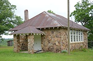
Stone County is home to several protected areas. These include Blanchard Springs Caverns, which are amazing underground caves, and the Ozark Folk Center. The Folk Center helps keep the traditions of the Ozarks alive, like mountain music and crafts. You can also see old log cabins, one-room school houses, and museums that share the county's history.
Stone County covers about 609 square miles (1,578 square kilometers). In 2020, about 12,359 people lived there.
Contents
Exploring Stone County's Geography
Stone County is located in the beautiful Ozark Mountains. This area is known for its hills and plateaus. The county is split into different parts, with some areas having flatter land and others having steeper hills. The White River forms the county's edge in the northeast.
The county is about 105 miles (169 km) north of Little Rock. It is surrounded by other counties in the Ozarks and some that are closer to the Arkansas River Valley.
Natural Wonders and Protected Areas
Stone County is home to part of the Ozark National Forest. This forest is a large protected area where you can find many trees and wildlife. One of its most famous spots is Blanchard Springs Caverns, a system of stunning caves.
Who Lives in Stone County?
| Historical population | |||
|---|---|---|---|
| Census | Pop. | %± | |
| 1880 | 5,089 | — | |
| 1890 | 7,043 | 38.4% | |
| 1900 | 8,100 | 15.0% | |
| 1910 | 8,946 | 10.4% | |
| 1920 | 8,779 | −1.9% | |
| 1930 | 7,993 | −9.0% | |
| 1940 | 8,603 | 7.6% | |
| 1950 | 7,662 | −10.9% | |
| 1960 | 6,294 | −17.9% | |
| 1970 | 6,838 | 8.6% | |
| 1980 | 9,022 | 31.9% | |
| 1990 | 9,775 | 8.3% | |
| 2000 | 11,499 | 17.6% | |
| 2010 | 12,394 | 7.8% | |
| 2020 | 12,359 | −0.3% | |
| 2023 (est.) | 12,671 | 2.2% | |
| U.S. Decennial Census 1790–1960 1900–1990 1990–2000 2010 |
|||
The 2020 United States census counted 12,359 people living in Stone County. There were 4,787 households and 3,109 families.
A Look at the Population (2020)
| Group | Number | Percentage |
|---|---|---|
| White (not Hispanic) | 11,387 | 92.14% |
| Black or African American (not Hispanic) | 21 | 0.17% |
| Native American | 87 | 0.7% |
| Asian | 25 | 0.2% |
| Pacific Islander | 2 | 0.02% |
| Other/Mixed | 566 | 4.58% |
| Hispanic or Latino | 271 | 2.19% |
A Look at the Population (2010)
In 2010, there were 12,394 people in Stone County. The county had about 20 people per square mile. Most people were White (96.8%).
About 26% of households had children under 18. Many households (67.4%) were married couples. The average household had 2.30 people.
The population included 20.6% under 18, and 22.8% who were 65 or older. The average age was 37.2 years. The median income for a family was $36,765.
Culture and Daily Life
Stone County has a rich culture, especially known for its traditional Ozark heritage.
Local News and History
The main newspaper in Stone County is the Stone County Leader. It's published every week in Mountain View and has been around since 1952.
The Stone County Historical Society publishes a magazine called Heritage of Stone. It comes out twice a year and shares stories about the county's history and culture.
Communities in Stone County
Stone County has two main cities and many smaller communities. Early settlers often lived in small groups, which is why there are so many tiny communities and even some ghost towns.
Cities to Visit
- Fifty-Six
- Mountain View (the county seat)
Smaller Communities (Unincorporated)
- Alco
- Allison
- Arlberg
- Ben
- Big Springs
- Chalybeate Springs
- East Richwoods
- Flag
- Fox
- Gayler
- Hanover
- Harness
- Herpel
- Luber
- Lydalisk
- Marcella
- Meadow Creek
- Melrose
- Mozart
- Newnata
- Old Lexington
- Onia
- Optimus
- Parma
- Pleasant Grove
- Pleasant Hill
- Rushing
- St. James
- Timbo
- Turkey Creek
- West Richwoods
Historical Communities (Ghost Towns)
- Bluetip
- Bothersome
- Boyle
- Buckhorn
- Hedges
- Kahoka
- May
- Oga
- Pekin
- Red Stripe
Townships (Local Divisions)
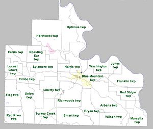
Townships are smaller areas within a county. Stone County has many townships.
- Arbana
- Blue Mountain
- Bryan
- Farris
- Flag
- Franklin
- Harris
- Jones
- Liberty
- Locust Grove
- Marcella
- Northwest
- Optimus
- Red River
- Red Stripe
- Richwoods
- Roasting Ear
- Smart
- Sylamore
- Timbo
- Turkey Creek
- Union
- Washington
- Wilson
Getting Around Stone County
Air Travel
Mountain View Airport is the only public airport in Stone County. It's a small airport used for general aviation. The closest big airport for commercial flights is Clinton National Airport in Little Rock.
Main Roads and Highways
Stone County does not have any major Interstate highways. The closest one is Interstate 40 (I-40) in Conway. However, there are ten state highways that help people travel through the county.
Highway 5 and Highway 9 are important roads that go north and south through the Ozarks, passing through Mountain View. Highway 14 is a major east-west road that also goes through Mountain View and Fifty-Six.
Other highways like Highway 87, Highway 66, and Highway 263 connect different communities. Highway 382 leads to the Ozark Folk Center State Park.
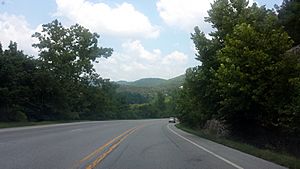
The county also has the Sylamore Scenic Byway. This is a special road known for its beautiful views.
Utilities and Services
Most of Stone County gets its electricity from Entergy Arkansas. Other parts are served by different electric cooperatives.
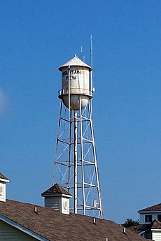
The Arkansas Department of Health makes sure that public water systems are safe. Stone County has several water systems, including those for Fifty-Six and Mountain View. Most of these systems get their water from the White River or buy treated water from Mountain View.
See also
 In Spanish: Condado de Stone (Arkansas) para niños
 | Georgia Louise Harris Brown |
 | Julian Abele |
 | Norma Merrick Sklarek |
 | William Sidney Pittman |


