
Blanchard Springs Caverns facts for kids
Quick facts for kids Blanchard Springs Cavern |
|
|---|---|

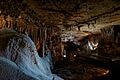
Speleothems in Blanchard Springs Cavern
|
|
| Location | Stone County, Arkansas, U.S. |
| Nearest city | Fifty-Six |
| Governing body | United States Forest Service |

Blanchard Springs Caverns is an amazing cave system in northern Arkansas. It's located in the Ozark–St. Francis National Forest. This cave is special because it's the only tourist cave owned by the United States Forest Service. It's also the only one owned by the U.S. government outside the National Park System.
You can explore Blanchard Springs Caverns on guided tours. The cave has three different levels.
There are a few types of tours for visitors:
- The Dripstone Trail takes you through the upper part of the cave. This trail is about half a mile long. It first opened to visitors in 1973.
- The Discovery Trail is a longer tour, about 1.2 miles. It goes deep into the cave, about 366 feet underground! This trail also leads to the Natural Entrance. Along this path, you'll see cool features like the Rimstone Dams. These dams create small pools of water. You'll also visit the Ghost Room, which has a huge white flowstone. The Discovery Trail opened in 1977.
- For the more adventurous, there's a "Wild Cave" tour. This tour lets you explore parts of the cave that aren't developed for regular visitors. You get to see the cave just like the first explorers did.
Contents
Exploring the Cave: What You'll See
When you visit Blanchard Springs Caverns, you'll see many incredible cave formations. These are often called speleothems. They form over thousands of years as water drips and flows through the limestone rock.
Stunning Formations
- Stalactites hang down from the cave ceiling, like icicles.
- Stalagmites grow up from the cave floor.
- Flowstones are like frozen waterfalls of rock. The "Giant Flowstone" in Blanchard Springs is one of the biggest in the U.S. It's about 164 feet long!
- Rimstone Dams are natural rock barriers that create pools of water.
The cave is still "living" because water continues to drip and flow. This means the formations are still slowly growing!
History of the Caverns
People in the area knew about parts of the cave by the 1930s. They called it "Half-Mile Cave."
When Was it Explored?
- Serious explorations of the cave began in the 1950s.
- Explorers continued to map and discover new parts of the cave through the 1960s.
- After about 10 years of work to prepare the Dripstone Trail, the caverns opened to the public in 1973.
How the Cave Was Formed
Blanchard Springs Caverns is the second longest cave in Arkansas. It's also the largest in terms of its size.
Ancient Seas and Rock Layers
- The limestone rock that makes up the cave formed a very long time ago. This was over 350 million years ago, when the area was covered by an ancient sea.
- Over millions of years, water slowly carved out the passages and rooms you see today.
- The cave has shown signs of forming at five different levels. However, the top two levels have worn away over time.
The Constant Spring
- A stream flows through the cave. This stream comes out of the cave at Blanchard Springs.
- The water in the spring stays at a constant temperature of 58°F (14°C) all year round.
Images for kids
-
Speleothems in Blanchard Springs Cavern
