Damascus, Arkansas facts for kids
Quick facts for kids
Damascus, Arkansas
|
|
|---|---|

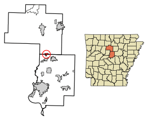
Location of Damascus in Faulkner County and Van Buren County, Arkansas.
|
|
| Country | |
| State | |
| Counties | |
| Incorporated | July 15, 1966 |
| Government | |
| • Type | Mayor-Council |
| Area | |
| • Total | 1.86 sq mi (4.82 km2) |
| • Land | 1.86 sq mi (4.82 km2) |
| • Water | 0.00 sq mi (0.00 km2) |
| Elevation | 696 ft (212 m) |
| Population
(2020)
|
|
| • Total | 389 |
| • Density | 205.16/sq mi (79.20/km2) |
| Time zone | UTC-6 (Central (CST)) |
| • Summer (DST) | UTC-5 (CDT) |
| ZIP code |
72039
|
| Area code | 501 |
| FIPS code | 05-17290 |
| GNIS ID | 2406351 |
| Website | Town of Damascus |
Damascus is a small town located in central Arkansas, United States. It sits partly in Faulkner and partly in Van Buren counties. In 2020, about 389 people lived there. The town is known for its beautiful location in the Ozark foothills.
Contents
Discovering Damascus: A Brief History
Damascus is found in the Ozark foothills. It sits on a flat area surrounded by clear streams. You can find it along U.S. Highway 65. This highway runs right on the county line between Faulkner and Van Buren counties.
The town is home to several churches. There are three Baptist churches. A Church of Christ was built in 1917. A Methodist church was built in 1947.
Damascus is also close to the Gus Blass Scout Reservation. This is a large Boy Scout Camp. It covers about 3,000 acres. The Quapaw Area Council takes care of it.
The Titan II Missile Incident of 1980
Damascus is most known for being near a special missile base. This was a Titan II missile base. It operated from 1963 until 1980.
In 1980, an accident happened at the base. An Air Force worker dropped a tool. It hit a missile, causing fuel to leak. The area was quickly cleared. Specialists came to help.
Hours later, the fuel vapors caught fire and exploded. One person was sadly killed. Twenty-one other people were hurt. The missile had a nuclear warhead, but it was found safely. No radiation was released into the environment. This event is sometimes called a "Broken Arrow" incident. This term means an accident involving nuclear weapons.
You can read more about this event. Eric Schlosser wrote a book about it in 2013. It is called Command and Control: Nuclear Weapons, the Damascus Accident, and the Illusion of Safety.
Geography of Damascus
Damascus covers a total area of about 5.0 square kilometers (1.86 square miles). All of this area is land. There is no water within the town's boundaries.
The part of Damascus in Faulkner County is in the northern area. It is part of the larger Little Rock–North Little Rock–Conway metropolitan area.
Population Facts
The population of Damascus has changed over the years.
- 1970: 255 people
- 1980: 307 people
- 1990: 246 people
- 2000: 306 people
- 2010: 382 people
- 2020: 382 people
In 2000, there were 306 people living in Damascus. The average age was 44 years old. About 21.2% of the people were under 18. About 25.8% were 65 or older.
Education in Damascus
Students in Damascus attend public schools. The South Side School District provides education. This includes both elementary and high school students.
Local Libraries
The town of Damascus has a library. It is part of the Faulkner-Van Buren Regional Library System. This library system was started in 1954. You can visit the Damascus Library for books and resources.
Notable People from Damascus
- Kim Hammer: He is a Republican member. He has served in the Arkansas House of Representatives since 2011. He grew up in Damascus.
See also
 In Spanish: Damascus (Arkansas) para niños
 | Percy Lavon Julian |
 | Katherine Johnson |
 | George Washington Carver |
 | Annie Easley |

