Sugarloaf Mountain (Cleburne County, Arkansas) facts for kids
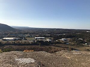
Sugarloaf Mountain is a famous landmark in Heber Springs, Arkansas, USA. It's a tall, unique mountain located near Greers Ferry Lake in Cleburne and Van Buren Counties. People love to visit it for its amazing views and fun hiking trails.
Contents
What is Sugarloaf Mountain?
This popular mountain is a great spot for climbing. It stands about 690 feet (210 meters) tall above a green valley east of Heber Springs.
How Sugarloaf Mountain Formed
Sugarloaf Mountain was shaped over millions of years by the Little Red River (Arkansas). Imagine the river slowly carving out the valley around it, leaving this strong mountain behind. Geologists explain that the huge rocks at the top are made of sandstone. These rocks are flat and haven't been folded by big movements of the Earth, so they protect the mountain underneath. Over time, softer rocks like siltstone and shale wore away, leaving the hard "Atoka formation" that we now call Sugarloaf.
The Mountain's Names and History
No one knows exactly how Sugarloaf Mountain got its name from early settlers. But Native Americans called it Tonawanda or Ton-Wan-Dah. From the top of Ton-Wan-Dah, with its few trees, they could see for miles around.
Tradition says the name Tonawanda came from a family of famous arrow makers. Even after white settlers arrived, many flint chips and broken arrowheads were found on the mountaintop, showing this history.
Early white settlers probably called it Sugar Loaf because it looked like the cone-shaped loaves of sugar used back then. In 1819, a group surveying the Louisiana Purchase noted "Sugar Lofe" as a well-known landmark. Native Americans and early travelers on the Little Red River likely used it as a guide. The mountain's name even became the name of the nearby springs and the community that grew there, which later became Heber Springs.
Who Owns Sugarloaf Mountain?
Sugarloaf Mountain sits on a property line, so its land has always been managed in two parts. For a few years starting in 1901, the Lucas brothers tried to find minerals or oil on the north side, but they didn't find any.
Later, in 1922, Dr. L.E. Robbins bought 40 acres (16 hectares) on the south side of the mountain. In 1951, he officially gained ownership of the 40 acres on the north side from the U.S. government.
Sugarloaf Becomes a Public Park
In 1951, Dr. Robbins and his wife, Dotte, gave 80 acres (32 hectares) of the mountain to the town of Heber Springs. They set up a 99-year lease, saying the land must be used as a public park and picnic area. The town could build picnic tables and grills. This meant that the mountain, which people had used as a public space for a long time, was officially given to everyone to enjoy.
Enjoying Sugarloaf Mountain
Climbing Sugarloaf has been a favorite activity for many generations in Heber Springs. Before cars were common, it was an easy day trip for young people. Now, with more tourists visiting because of the Greers Ferry Dam and lake, Sugarloaf is popular far beyond the local area. Some people have even had their weddings on top of the mountain!
Sugarloaf and Arkansas State University
In 2005, Arkansas State University Beebe got the land with Sugarloaf Mountain for its ASU-Heber Springs campus. The first buildings for the campus were finished in 2007.
The Sugarloaf Heritage Council
In 2007, the Sugarloaf Heritage Council was created. This group, made up of local leaders and volunteers, worked hard to clean up the mountain. They rappelled down the steep rocks to remove a lot of graffiti. With the help of over 200 volunteers, they removed 600 pounds (272 kg) of trash!
They also built three trails:
- The Tonowanda Base Trail
- The Summit Trail
- Hidden Pond Trail
More volunteers and Eagle Scout projects built benches along the trails. The parking lot is now paved, and the entrance has a beautiful green space with picnic tables. Sugarloaf Mountain is truly known as the "Jewel of Heber Springs."
The Island Sugar Loaf
There's another "Sugar Loaf" mountain in the upper part of Greers Ferry Lake, but this one is an island! You can only get to it by boat. It's also a popular place for hiking, with a well-kept trail called "The Sugar Loaf Mountain Island National Nature Trail."
This trail is about 1.5 miles (2.4 km) long and reaches 1001 feet (305 meters) above sea level. From the top, you get amazing views of the lake and the countryside. Unlike the landlocked Sugarloaf, the climb on the island peak has a wooden staircase to help hikers. Like many other spots on the lake, Sugar Loaf island has a nearby campground and boat ramp (on the main shore) that are managed by the United States Army Corps of Engineers.
 | Aurelia Browder |
 | Nannie Helen Burroughs |
 | Michelle Alexander |


