Independence County, Arkansas facts for kids
Quick facts for kids
Independence County
|
|||
|---|---|---|---|

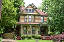
Historic Charles R. Handford House in Batesville.
|
|||
|
|||

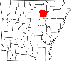
Location within the U.S. state of Arkansas
|
|||
 Arkansas's location within the U.S. |
|||
| Country | |||
| State | |||
| Founded | October 20, 1820 | ||
| Named for | United States Declaration of Independence | ||
| Seat | Batesville | ||
| Largest city | Batesville | ||
| Area | |||
| • Total | 772 sq mi (2,000 km2) | ||
| • Land | 764 sq mi (1,980 km2) | ||
| • Water | 7.6 sq mi (20 km2) 1.0%% | ||
| Population
(2020)
|
|||
| • Total | 37,938 | ||
| • Density | 49.14/sq mi (18.974/km2) | ||
| Time zone | UTC−6 (Central) | ||
| • Summer (DST) | UTC−5 (CDT) | ||
| Congressional district | 1st | ||
Independence County is a county in the state of Arkansas. In 2020, about 37,938 people lived here. The main city and county seat is Batesville.
Independence County was created on October 20, 1820. It was formed from a part of Lawrence County. The county was named to remember the Declaration of Independence.
Contents
Where is Independence County?
According to the U.S. Census Bureau, Independence County covers a total area of 772 square miles (1,999 square kilometers). Most of this area, 764 square miles (1,979 square kilometers), is land. The rest, about 7.6 square miles (20 square kilometers), is water.
Major Roads in the County
Many important roads help people travel through Independence County. These include:
 U.S. Highway 167
 Arkansas Highway 14
 Arkansas Highway 25
 Arkansas Highway 37
 Arkansas Highway 69
 Arkansas Highway 69 Business
 Arkansas Highway 87
 Arkansas Highway 106
 Arkansas Highway 122
 Arkansas Highway 157
 Arkansas Highway 230
 Arkansas Highway 233
 Arkansas Highway 333
 Arkansas Highway 367
 Arkansas Highway 394
Neighboring Counties
Independence County shares borders with several other counties:
- Sharp County (to the north)
- Lawrence County (to the northeast)
- Jackson County (to the east)
- White County (to the south)
- Cleburne County (to the southwest)
- Stone County (to the west)
- Izard County (to the northwest)
How Many People Live Here?
| Historical population | |||
|---|---|---|---|
| Census | Pop. | %± | |
| 1830 | 2,031 | — | |
| 1840 | 3,669 | 80.6% | |
| 1850 | 7,767 | 111.7% | |
| 1860 | 14,307 | 84.2% | |
| 1870 | 14,566 | 1.8% | |
| 1880 | 18,086 | 24.2% | |
| 1890 | 21,961 | 21.4% | |
| 1900 | 22,557 | 2.7% | |
| 1910 | 24,776 | 9.8% | |
| 1920 | 23,976 | −3.2% | |
| 1930 | 24,225 | 1.0% | |
| 1940 | 25,643 | 5.9% | |
| 1950 | 23,488 | −8.4% | |
| 1960 | 20,048 | −14.6% | |
| 1970 | 22,723 | 13.3% | |
| 1980 | 30,147 | 32.7% | |
| 1990 | 31,192 | 3.5% | |
| 2000 | 34,233 | 9.7% | |
| 2010 | 36,647 | 7.1% | |
| 2020 | 37,938 | 3.5% | |
| 2023 (est.) | 38,320 | 4.6% | |
| U.S. Decennial Census 1790–1960 1900–1990 1990–2000 2010 |
|||
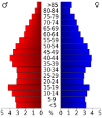
As of the 2020 United States census, there were 37,938 people living in Independence County. These people lived in 14,322 households. There were also 9,929 families.
Towns and Cities
Independence County has several cities, towns, and smaller communities.
Cities
- Batesville (This is the county seat)
- Cave City
- Cushman
- Newark
- Southside
Towns
Census-Designated Places
These are areas that are like towns but are not officially incorporated as cities or towns.
Other Small Communities
These are smaller places that are not officially cities or towns.
- Antioch (Independence County)
- Cedar Grove
- Charlotte
- Cord
- Dota
- Gainsboro
- Jamestown
- Limedale
- Locust Grove
- McHue
- Pfeiffer
- Rosie
- Sandtown
- Thida
- Walnut Grove
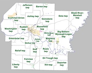
County Townships
Townships are smaller divisions within the county. Townships in Arkansas are the divisions of a county. Each township includes unincorporated areas; some may have incorporated cities or towns within part of their boundaries. Arkansas townships have limited purposes in modern times. However, the United States Census does list Arkansas population based on townships (sometimes referred to as "county subdivisions" or "minor civil divisions"). Townships are also of value for historical purposes in terms of genealogical research. Each town or city is within one or more townships in an Arkansas county based on census maps and publications. The townships of Independence County are listed below; listed in parentheses are the cities, towns, and/or census-designated places that are fully or partially inside the township.
- Ashley
- Barren (includes part of Cave City)
- Big Bottom-Wycough-Logan Township (includes Newark)
- Black River-Marshell
- Cushman-Union (includes Cushman)
- Departee
- Dota
- Fairview (includes Pleasant Plains)
- Gainsboro
- Greenbrier
- Hill
- Huff
- Jefferson
- Liberty
- McHue (includes part of Batesville)
- Magness (includes Magness)
- Moorefield (includes Moorefield, part of Batesville)
- Oil Trough (includes Oil Trough)
- Relief
- Rosie
- Ruddell (includes most of Batesville)
- Salado
- Washington
- White River (includes Sulphur Rock)
See also
 In Spanish: Condado de Independence para niños
 | Audre Lorde |
 | John Berry Meachum |
 | Ferdinand Lee Barnett |


