Southside, Independence County, Arkansas facts for kids
Quick facts for kids
Southside, Arkansas
|
|
|---|---|

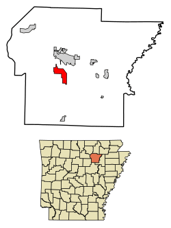
Location of Southside in Independence County, Arkansas.
|
|
| Country | United States |
| State | Arkansas |
| County | Independence |
| Incorporated | 2014 |
| Area | |
| • Total | 9.86 sq mi (25.53 km2) |
| • Land | 9.86 sq mi (25.53 km2) |
| • Water | 0.00 sq mi (0.01 km2) |
| Elevation | 374 ft (114 m) |
| Population
(2020)
|
|
| • Total | 4,279 |
| • Density | 434.20/sq mi (167.64/km2) |
| Time zone | UTC-6 (CST) |
| • Summer (DST) | UTC-5 (CDT) |
| FIPS code | 05-65630 |
| GNIS feature ID | 2771128 |
Southside is a city located in Independence County, Arkansas, in the United States. It is a place where many families live and work.
The city of Southside sits about 354 feet (108 meters) above sea level. A special road, a spur route of Arkansas Highway 14, connects Southside to the nearby community of Salado.
Southside's History
Southside became an official city on October 29, 2014. When a place is "incorporated," it means it has its own local government. This government can make decisions for the community.
Who Lives in Southside?
Demographics is the study of a population. It looks at things like how many people live in an area and what groups they belong to. The table below shows the different groups of people living in Southside as of 2020.
| Race | Number | Percentage |
|---|---|---|
| White (NH) | 3,660 | 85.53% |
| Black or African American (NH) | 79 | 1.85% |
| Native American or Alaska Native (NH) | 6 | 0.14% |
| Asian (NH) | 31 | 0.72% |
| Pacific Islander (NH) | 2 | 0.05% |
| Some Other Race (NH) | 4 | 0.09% |
| Mixed/Multi-Racial (NH) | 249 | 5.82% |
| Hispanic or Latino | 248 | 5.8% |
| Total | 4,279 |
The 2020 United States census counted 4,279 people living in Southside. These people made up 1,560 households. Out of these households, 1,002 were families.
 | Precious Adams |
 | Lauren Anderson |
 | Janet Collins |

