Pulaski County, Arkansas facts for kids
Quick facts for kids
Pulaski County
|
|||
|---|---|---|---|

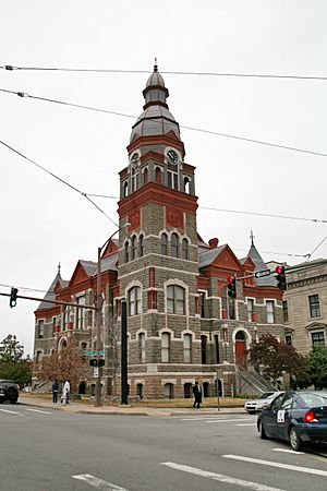
Pulaski County Courthouse, in downtown Little Rock
|
|||
|
|||

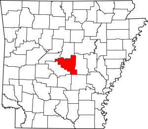
Location within the U.S. state of Arkansas
|
|||
 Arkansas's location within the U.S. |
|||
| Country | |||
| State | |||
| Founded | December 15, 1818 | ||
| Named for | Casimir Pulaski | ||
| Seat | Little Rock | ||
| Largest city | Little Rock | ||
| Area | |||
| • Total | 808 sq mi (2,090 km2) | ||
| • Land | 760 sq mi (2,000 km2) | ||
| • Water | 48 sq mi (120 km2) 5.9%% | ||
| Population
(2020)
|
|||
| • Total | 399,125 | ||
| • Estimate
(2023)
|
400,009 |
||
| • Density | 493.97/sq mi (190.72/km2) | ||
| Time zone | UTC−6 (Central) | ||
| • Summer (DST) | UTC−5 (CDT) | ||
| Congressional districts | 1st, 2nd, 4th | ||
Pulaski County is a special area in the state of Arkansas. It's like a big neighborhood with its own government. As of 2020, it's the most populated county in Arkansas, with almost 400,000 people living there.
The county is part of a larger city area that includes Little Rock, North Little Rock, and Conway. Little Rock is the main city in Pulaski County. It's also the capital city of Arkansas and the biggest city in the state!
Pulaski County was one of the first counties created in Arkansas. It was formed on December 15, 1818. The county is named after Brigadier General Casimir Pulaski. He was a brave soldier from Poland who helped America during the Revolutionary War. He sadly died in battle.
During the Civil War, a battle called the Battle of Bayou Fourche happened here on September 10, 1863. The Union army took control of the county that day. They stayed until the war ended. Pulaski County was also home to Willow Springs Water Park. It was one of the oldest water parks in the country, open from 1928 to 2013.
Contents
What is Pulaski County Like?
According to the U.S. Census Bureau, Pulaski County covers a total area of about 808 square miles. Most of this area, about 760 square miles, is land. The rest, about 48 square miles, is water. This means about 5.9% of the county is covered by water.
Main Roads and Highways
Many important roads run through Pulaski County. These roads help people travel easily around the county and to other parts of Arkansas.
 I-30
I-30 I-40
I-40 Future I-57
 I-430
I-430 I-440
I-440 I-530
I-530 I-630
I-630 U.S. Highway 65
 U.S. Highway 67
 U.S. Highway 70
 U.S. Highway 165
 U.S. Highway 167
 Highway 5
 Highway 10
 Highway 100
 Highway 161
 Highway 300
 Highway 338
 Highway 365
 Highway 367
Getting Around (Transit)
You can get around Pulaski County using different types of transportation:
- Rock Region Metro (which includes the Metro Streetcar)
- Amtrak Texas Eagle train (stops at the Little Rock station)
- Greyhound Lines (bus service)
- Jefferson Lines (bus service)
Neighboring Counties
Pulaski County shares its borders with several other counties:
- Faulkner County (to the north)
- Lonoke County (to the east)
- Grant County (to the south)
- Jefferson County (to the south)
- Saline County (to the west)
- Perry County (to the northwest)
Special Protected Areas
- Little Rock Central High School National Historic Site is a very important place in Pulaski County. It's a national historic site that remembers a key moment in the Civil Rights Movement.
Who Lives in Pulaski County?
| Historical population | |||
|---|---|---|---|
| Census | Pop. | %± | |
| 1830 | 2,395 | — | |
| 1840 | 5,350 | 123.4% | |
| 1850 | 5,657 | 5.7% | |
| 1860 | 11,699 | 106.8% | |
| 1870 | 32,066 | 174.1% | |
| 1880 | 32,616 | 1.7% | |
| 1890 | 47,329 | 45.1% | |
| 1900 | 63,179 | 33.5% | |
| 1910 | 86,751 | 37.3% | |
| 1920 | 109,464 | 26.2% | |
| 1930 | 137,727 | 25.8% | |
| 1940 | 156,085 | 13.3% | |
| 1950 | 196,685 | 26.0% | |
| 1960 | 242,980 | 23.5% | |
| 1970 | 287,189 | 18.2% | |
| 1980 | 340,613 | 18.6% | |
| 1990 | 349,660 | 2.7% | |
| 2000 | 361,474 | 3.4% | |
| 2010 | 382,748 | 5.9% | |
| 2020 | 399,125 | 4.3% | |
| 2023 (est.) | 400,009 | 4.5% | |
| U.S. Decennial Census 1790–1960 1900–1990 1990–2000 2010–2020 2020 |
|||
The U.S. Census helps us understand the people living in Pulaski County. As of the 2020 census, there were 399,125 people. These people lived in about 158,000 households. About 93,080 of these households were families.
Different Backgrounds in Pulaski County (2020 Census)
Pulaski County is home to people from many different backgrounds. Here's a look at the main groups:
| Race | Number | Percentage |
|---|---|---|
| White (not Hispanic) | 193,993 | 48.6% |
| Black or African American (not Hispanic) | 142,139 | 35.61% |
| Native American | 1,169 | 0.29% |
| Asian | 9,933 | 2.49% |
| Pacific Islander | 208 | 0.05% |
| Other/Mixed | 18,530 | 4.64% |
| Hispanic or Latino | 33,153 | 8.31% |
Learning and Schools
Pulaski County has many great places for learning, from colleges to special schools.
- Pulaski Technical College is a two-year college. It has seven locations across the county. Its main campus is in North Little Rock.
- For four-year degrees, there's the University of Arkansas at Little Rock. It's the only university campus in the University of Arkansas System located in a big city.
- Other colleges in Little Rock include Philander Smith College, Arkansas Baptist College, and the University of Arkansas for Medical Sciences.
Here are some of the school districts in the county:
- Jacksonville North Pulaski School District
- Little Rock School District
- North Little Rock School District
- Pulaski County Special School District
- East End School District
There are also special schools for students with specific needs:
- Arkansas School for the Blind
- Arkansas School for the Deaf
Towns and Cities in Pulaski County
Pulaski County has several cities and towns where people live and work.
Cities
- Cammack Village
- Jacksonville
- Little Rock (This is the main city and county seat!)
- Maumelle
- North Little Rock
- Sherwood
- Wrightsville
Town
- Alexander (most of this town is in Saline County)
Other Communities (Census-Designated Places)
These are areas that are like towns but are not officially incorporated as cities or towns.
More Communities in the County
These are other smaller places where people live in Pulaski County.
- Crystal Hill
- Gravel Ridge
- Ironton
- Little Italy
- Mabelvale
- Marche
- Pankey
- Woodyardville
Townships: How the County is Divided
In Arkansas, counties are divided into smaller areas called townships. These townships include areas that are not part of any city or town. They might also have parts of cities or towns within them. Today, townships don't have many official duties. However, the U.S. Census still uses them to count populations. They are also helpful for looking at history and family research. Pulaski County has two townships:
| Township | Main Cities/Towns | Population (2010) |
Land area (sq mi) |
|
|---|---|---|---|---|
| Big Rock | Alexander, Cammack Village, Little Rock, Wrightsville | 219,984 | 404.014 | 1,046 |
| Hill | Jacksonville, Maumelle, North Little Rock, Sherwood | 162,764 | 355.750 | 921.4 |
Famous People from Pulaski County
- Karilyn Brown, who is a member of the Arkansas House of Representatives (a political leader for the state).
- Granville Ryles (1831–1909), who was a minister, farmer, and state legislator in Arkansas a long time ago.
See also
 In Spanish: Condado de Pulaski (Arkansas) para niños
 | Misty Copeland |
 | Raven Wilkinson |
 | Debra Austin |
 | Aesha Ash |


