Metro Streetcar facts for kids
Quick facts for kids Metro Streetcar |
|
|---|---|

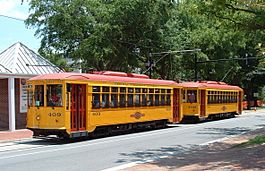
Two Metro streetcars pause at the HAM stop in June 2005
|
|
| Overview | |
| Owner | Rock Region Metro |
| Locale | Little Rock, Arkansas |
| Termini | North Little Rock (north) Presidential Library (south) |
| Stations | 15 |
| Website | METRO Streetcar |
| Service | |
| Type | Heritage streetcar |
| System | Rock Region Metro |
| Operator(s) | Rock Region Metro |
| Rolling stock | 5 cars |
| Daily ridership | 340 |
| History | |
| Opened | November 1, 2004 |
| Technical | |
| Line length | 3.4 mi (5.5 km) |
| Track gauge | 4 ft 8 1⁄2 in (1,435 mm) |
| Electrification | 600 V DC, overhead trolley wire |
The Metro Streetcar is a special kind of train system. It runs on tracks in the streets of Little Rock and North Little Rock, Arkansas. It's called a heritage streetcar because it uses old-fashioned streetcars. This system started running on November 1, 2004. After growing in 2007, the Metro Streetcar tracks became 3.4-mile (5.5 km) long. The company that runs it is called Rock Region Metro.
Contents
History of Streetcars in Little Rock
Early Streetcar Systems
By the 1890s, Little Rock began to grow. This was largely because of its street railway system. Like many cities in the South after the Civil War, Little Rock attracted business people. They wanted to take advantage of new growth.
Little Rock's first streetcar line opened in 1876. These first streetcars were pulled by horses! They were called horsecars. Horsecars ran until 1895. For a short time, from 1888 to 1889, steam-powered streetcars also operated.
Electric Streetcars Arrive
Electric streetcars came to Little Rock on December 23, 1891. A company was formed just to run the streetcar system. Later, a company called Arkansas Power & Light bought it.
Electric streetcars ran until September 1, 1947. They went as far west as the Hillcrest and Stifft's Station areas of the city.
The Modern Metro Streetcar Begins
The system we now call the Metro Streetcar opened on November 1, 2004. It was first known as the River Rail Streetcar. The Central Arkansas Transit Authority operated it.
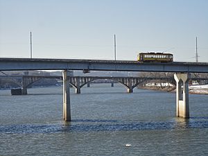
The first part of the line was 2.5-mile (4.0 km) long. It connected Little Rock and North Little Rock. These two cities are on opposite sides of the Arkansas River. In its first year, 200,000 people rode the streetcar!
Growing the System
In January 2006, work began on the second part of the line. This was a 0.9-mile (1.4 km) extension. It went to the William J. Clinton Presidential Center and Heifer International headquarters.
This new section opened on February 16, 2007. Important leaders like Pulaski County Judge Buddy Villines and the mayors of Little Rock and North Little Rock were there. This extension made the line about 33% longer. The total length became 3.4 miles (5.5 km).
In 2015, the Central Arkansas Transit Authority changed its name. It became Rock Region Metro. Because of this, the River Rail Streetcar was renamed the Metro Streetcar.
Future Plans for Expansion
There are talks about making the streetcar system even bigger. One big idea is to extend it 2.5-mile (4 km) to the Little Rock National Airport.
If this expansion happens, the line could become more like a light rail system. It would be more than just a heritage trolley. This type of expansion is sometimes called a "rapid streetcar." It would be the first of its kind in the United States.
The Streetcar Vehicles
What the Streetcars Look Like
The Metro Streetcar system started with three replica electric trolleys. These are copies of old streetcars. Two more streetcars were added when the second part of the line opened.
The design of these cars looks like the old Birney-type streetcars. Those cars were used in Little Rock until after World War II. The original old cars had numbers from 400 to 407. The new cars continue this number series. They are numbered 408 to 412. All the streetcars in the current fleet were made by the Gomaco Trolley Company.
How the Streetcar Operates
Operating Hours and Lines
The Metro Streetcar usually starts running around 8:30 a.m. Monday through Saturday. On Sundays, it starts at 10 a.m. It stops running around 10 p.m. Monday through Wednesday. On Fridays and Saturdays, it runs until midnight. On Sundays, it stops at 5:30 p.m.
The system has two lines: the Blue Line and the Green Line.
- The Blue Line runs seven days a week. It has longer service on Friday and Saturday nights. It travels between Little Rock and North Little Rock.
- The Green Line runs six days a week, with no Sunday service. It runs in a loop.
Streetcars usually come every 25 minutes during the day. In the evenings, nights, and on weekends, they come every 20 minutes.
Streetcar Stops
Places to Visit Along the Way
The streetcar stops at many interesting places downtown. These include the Clinton Library and the historic River Market. Other stops include the Marriott Hotel, Heifer Intl., and the Historic Arkansas Museum.
The stops also go into North Little Rock, in an area called Argenta. Stops there let you visit the USS Razorback (SS-394) World War II submarine. You can also see the trolley barn, Verizon Arena, and Dickey-Stephens Park. Dickey-Stephens Park is home to the Arkansas Travelers baseball team.
The stops are easy to spot. They have 10-foot (3.05 m)-tall black signs. There are also yellow "bumps" on the sidewalk. Each stop has a map of the system. You cannot wave down a trolley between stops.
List of Stops
Lines
Blue Line
Green Line
Highlighted stops indicate daytime only service
| No. | Stop | Jurisdiction | Line(s) | Notes |
|---|---|---|---|---|
| south and east bound | ||||
| 1 | Main Street and Bishop Lindsey Avenue | North Little Rock | First stop past the streetcar garage Serves Argenta Historic District |
|
| 2 | Maple and Sixth Streets | |||
| 3 | Maple and Broadway Streets | |||
| 4 | 120 Main Street (Verizon Plaza stop) |
Serves North Little Rock City Hall, Riverfront Park and Verizon Arena | ||
| 5 | Scott and Markham Streets (Main Street Bridge stop) |
Little Rock | Serves Little Rock Chamber of Commerce | |
| 6 | President Clinton and River Market Avenues | Serves Breciding Riverfront Park and Junction Bridge | ||
| 7 | River Market Avenue and Third Street | Serves River Market District | ||
| 8 | World Avenue and Third Street (Clinton Presidential Center/Heifer International stop) |
Serves Clinton Presidential Center and Heifer International | ||
| west and north bound | ||||
| 8 | World Avenue and Third Street (Clinton Presidential Center/Heifer International stop) |
Little Rock | Serves Clinton Presidential Center and Heifer International | |
| 9 | Third Street and River Market Avenue | Serves River Market District | ||
| 10 | Second and Rock Streets (Central Arkansas Library System Main Branch stop) |
Serves Central Arkansas Library System Main Library | ||
| 11 | Second and Scott Streets (Historic Arkansas Museum stop) |
Serves Historic Arkansas Museum | ||
| 12 | Second and Center Streets | |||
| 13 | West Markham and Spring Streets | Serves Robinson Auditorium | ||
| 14 | West Markham and Scott Streets (Little Rock Marriott stop) |
Serves Little Rock Marriott Hotel, Capital Hotel and Statehouse Convention Center | ||
| 5 | Scott and Markham Streets (Main Street Bridge stop) |
Serves Little Rock Chamber of Commerce | ||
| 4 | 120 Main Street (Verizon Plaza stop) |
North Little Rock | Serves North Little Rock City Hall, Riverfront Park and Verizon Arena | |
| 15 | Main and Fifth Streets | final stop before streetcar barn | ||
See also
 In Spanish: Tranvía de Little Rock para niños
 | Kyle Baker |
 | Joseph Yoakum |
 | Laura Wheeler Waring |
 | Henry Ossawa Tanner |


