Wrightsville, Arkansas facts for kids
Quick facts for kids
Wrightsville, Arkansas
|
|
|---|---|
| City of Wrightsville | |
| Motto(s):
People, Progress, Prosperity
|
|

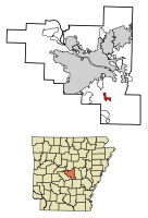
Location in Pulaski County and Arkansas
|
|
| Country | United States |
| State | |
| County | Pulaski |
| Township | Big Rock |
| Founded | July 14, 1873 |
| Incorporated | June 2, 1982 |
| Government | |
| • Type | Mayor–Council |
| Area | |
| • Total | 2.14 sq mi (5.53 km2) |
| • Land | 2.12 sq mi (5.48 km2) |
| • Water | 0.02 sq mi (0.05 km2) |
| Elevation | 236 ft (72 m) |
| Population
(2020)
|
|
| • Total | 1,542 |
| • Density | 728.73/sq mi (281.34/km2) |
| Time zone | UTC-6 (Central (CST)) |
| • Summer (DST) | UTC-5 (CDT) |
| ZIP code |
72183
|
| Area code(s) | 501 |
| FIPS code | 05-76970 |
| GNIS feature ID | 2405794 |
| Highways | |
| Major airport | Clinton Airport (LIT) |
Wrightsville is a city located in Pulaski County, Arkansas, in the United States. In 2020, about 1,542 people lived there. It is part of the larger Little Rock area.
Wrightsville is found along Highway 365. For over 100 years, it was a small, unorganized community. It officially became a city in the late 1900s. Since 1981, a large facility run by the Arkansas Department of Corrections has been in Wrightsville. This facility is a main employer for many people in the city.
Contents
Exploring Wrightsville's Location
Wrightsville is located at coordinates 34.610434 degrees North and -92.217113 degrees West.
The United States Census Bureau says the city covers a total area of about 2.1 square miles (5.5 square kilometers). Most of this area, about 2.0 square miles (5.2 square kilometers), is land. A very small part, about 0.49%, is water.
History of the Arkansas Negro Boys' Industrial School
The Arkansas Negro Boys' Industrial School was a special facility for young Black boys in Arkansas. It operated from 1927 to 1968. In 1936, there were two locations. One was in Jefferson County, and the other was in Wrightsville. The Wrightsville location was about 10 miles (16 km) southeast of Little Rock. This school was a type of correctional facility for youth.
People Living in Wrightsville
| Historical population | |||
|---|---|---|---|
| Census | Pop. | %± | |
| 1990 | 1,062 | — | |
| 2000 | 1,368 | 28.8% | |
| 2010 | 2,114 | 54.5% | |
| 2020 | 1,542 | −27.1% | |
| U.S. Decennial Census | |||
Understanding the 2020 Census Data
The 2020 United States census counted 1,542 people living in Wrightsville. There were 276 households and 143 families in the city.
| Race | Number | Percentage |
|---|---|---|
| White (not Hispanic or Latino) | 544 | 35.28% |
| Black or African American (not Hispanic or Latino) | 923 | 59.86% |
| Native American | 3 | 0.19% |
| Asian | 3 | 0.19% |
| Pacific Islander | 4 | 0.26% |
| Other/Mixed | 20 | 1.3% |
| Hispanic or Latino | 45 | 2.92% |
Wrightsville's Economy and Jobs
The Arkansas Department of Corrections (ADC) runs a facility in Wrightsville. This facility is a big employer in the community. It has 169 employees who work in many different areas. The land where this facility is located used to be the site of the Arkansas Negro Boys' Industrial School.
Wrightsville is also home to a radio station, KLAL-FM. The U.S. Postal Service also has a post office in Wrightsville.
Education in Wrightsville
Students in Wrightsville attend schools that are part of the Pulaski County Special School District. Young students go to Daisy Bates Elementary School. Older students attend Mills Middle School and Wilbur D. Mills University Studies High School.
See also
 In Spanish: Wrightsville (Arkansas) para niños
 | William M. Jackson |
 | Juan E. Gilbert |
 | Neil deGrasse Tyson |


