
Sherwood, Arkansas facts for kids
Quick facts for kids
Sherwood, Arkansas
|
|||
|---|---|---|---|
|
|||

Location of Sherwood in Pulaski County, Arkansas.
|
|||

Sherwood, Arkansas
Location in Arkansas
|
|||
| Country | United States | ||
| State | Arkansas | ||
| County | Pulaski | ||
| Incorporated (city) | April 22, 1948 | ||
| Government | |||
| • Type | Mayor–council | ||
| Area | |||
| • Total | 21.15 sq mi (54.79 km2) | ||
| • Land | 20.74 sq mi (53.73 km2) | ||
| • Water | 0.41 sq mi (1.06 km2) | ||
| Elevation | 331 ft (101 m) | ||
| Population
(2020)
|
|||
| • Total | 32,731 | ||
| • Density | 1,577.85/sq mi (609.22/km2) | ||
| Time zone | UTC−6 (Central (CST)) | ||
| • Summer (DST) | UTC−5 (CDT) | ||
| ZIP code |
72120
|
||
| Area code(s) | 501 | ||
| FIPS code | 05-63800 | ||
| GNIS feature ID | 2405460 | ||


Sherwood is a city located in Pulaski County, Arkansas, United States. In 2020, about 32,731 people lived there. This makes Sherwood the 13th largest city in Arkansas. It is part of a bigger area called the Little Rock-North Little Rock-Conway metropolitan area, which had almost 700,000 people in 2010.
Contents
Sherwood's History
Sherwood officially became a town on April 22, 1948. It grew quickly!
- On September 16, 1957, it became a city of the Second Class.
- Then, on April 30, 1971, it became a city of the First Class.
On March 31, 2023, a strong tornado passed through Sherwood. It caused some damage to the city. The tornado first started near Little Rock before moving towards Sherwood.
Geography and Climate
Sherwood is located in Arkansas. The city covers about 54 square kilometers (21 square miles). Most of this area is land, with a small part being water.
Sherwood's Climate
Sherwood has a humid subtropical climate. This means it has hot, humid summers and mild winters. The city experiences all four seasons.
- Summer: July is the hottest month. The average high temperature is 92°F (33°C). Temperatures can sometimes go above 100°F (38°C).
- Winter: January is the coldest month. The average high is 50°F (10°C), and the average low is 33°F (1°C).
- Records: The highest temperature ever recorded was 110°F (43°C) in July 1986. The lowest was -6°F (-21°C) in January 1985.
| Climate data for Sherwood, Arkansas (1981–2010 normals) | |||||||||||||
|---|---|---|---|---|---|---|---|---|---|---|---|---|---|
| Month | Jan | Feb | Mar | Apr | May | Jun | Jul | Aug | Sep | Oct | Nov | Dec | Year |
| Record high °F (°C) | 81 (27) |
83 (28) |
87 (31) |
94 (34) |
98 (37) |
102 (39) |
110 (43) |
105 (41) |
102 (39) |
92 (33) |
84 (29) |
78 (26) |
110 (43) |
| Mean daily maximum °F (°C) | 50 (10) |
55 (13) |
64 (18) |
73 (23) |
80 (27) |
88 (31) |
92 (33) |
92 (33) |
84 (29) |
73 (23) |
62 (17) |
51 (11) |
72 (22) |
| Mean daily minimum °F (°C) | 33 (1) |
37 (3) |
44 (7) |
53 (12) |
62 (17) |
69 (21) |
73 (23) |
72 (22) |
65 (18) |
54 (12) |
44 (7) |
35 (2) |
53 (12) |
| Record low °F (°C) | −6 (−21) |
4 (−16) |
14 (−10) |
30 (−1) |
40 (4) |
52 (11) |
60 (16) |
53 (12) |
41 (5) |
27 (−3) |
14 (−10) |
−2 (−19) |
−6 (−21) |
| Average precipitation inches (mm) | 3.42 (87) |
3.80 (97) |
4.77 (121) |
4.79 (122) |
4.96 (126) |
3.31 (84) |
3.81 (97) |
2.80 (71) |
3.31 (84) |
4.80 (122) |
5.39 (137) |
5.01 (127) |
50.17 (1,274) |
| Source: The Weather Channel | |||||||||||||
Sherwood's Population
| Historical population | |||
|---|---|---|---|
| Census | Pop. | %± | |
| 1950 | 717 | — | |
| 1960 | 1,222 | 70.4% | |
| 1970 | 2,754 | 125.4% | |
| 1980 | 10,423 | 278.5% | |
| 1990 | 18,893 | 81.3% | |
| 2000 | 21,511 | 13.9% | |
| 2010 | 29,523 | 37.2% | |
| 2020 | 32,731 | 10.9% | |
| U.S. Decennial Census | |||
People in Sherwood (2010)
In 2010, there were 29,523 people living in Sherwood.
- About 75.3% of the people were White.
- About 18.5% were Black or African American.
- About 4.0% of the population was Hispanic or Latino.
- There were 12,207 households. About 30.5% of these households had children under 18.
- The average household had 2.41 people.
People in Sherwood (2020)
In 2020, the population of Sherwood grew to 32,731 people.
| Race | Number | Percentage |
|---|---|---|
| White (non-Hispanic) | 20,071 | 61.32% |
| Black or African American (non-Hispanic) | 8,228 | 25.14% |
| Native American | 91 | 0.28% |
| Asian | 647 | 1.98% |
| Pacific Islander | 13 | 0.04% |
| Other/Mixed | 1,850 | 5.65% |
| Hispanic or Latino | 1,831 | 5.59% |
There were 12,337 households and 8,324 families living in the city.
Economy and Jobs
Sherwood has several important employers.
- Big companies like FTD.com and Cardinal Health have customer service centers here.
- CHI St Vincent's North Hospital is another major employer.
- In 2017, there were 569 businesses in Sherwood that hired people. Many of these businesses were owned by men (304) or women (139).
Gravel Ridge Community
The area known as Gravel Ridge used to be a separate community. It was located between Jacksonville and the Sylvan Hills part of Sherwood. In 2000, Gravel Ridge had a population of 3,232 people.
Gravel Ridge Joins Sherwood
For many years, Gravel Ridge had connections to both Jacksonville and Sherwood. It shared a phone number prefix with Sherwood and a ZIP code with Jacksonville.
In 2008, both Jacksonville and Sherwood wanted Gravel Ridge to join their city.
- Jacksonville held an election on February 5, 2008.
- Sherwood held its own election on March 11, 2008.
- In both elections, residents of each city and Gravel Ridge voted to join either Jacksonville or Sherwood.
Because both cities voted yes, a third special election was held just for Gravel Ridge residents on April 1, 2008. The people of Gravel Ridge voted to become part of Sherwood.
Gravel Ridge officially became part of Sherwood on April 28, 2008. The area was then divided and added to different parts of Sherwood.
Education in Sherwood
Sherwood has many schools for students of all ages. After high school, many students go to colleges nearby. These include the University of Arkansas at Little Rock and the University of Central Arkansas.
Public Schools


The public schools in Sherwood are managed by the Pulaski County Special School District.
- The main public high school is Sylvan Hills High School.
- Other public schools include:
- Sylvan Hills Junior High School
- Sylvan Hills Middle School
- Cato Elementary School
- Bill Clinton Elementary Magnet School
- Oakbrooke Elementary School
- Sherwood Elementary School
- Sylvan Hills Elementary School
In 2008, LISA Academy North opened. It is a public charter school that focuses on STEM fields (Science, Technology, Engineering, and Math).
Private Schools
Sherwood also has several private schools:
- Abundant Life Christian Academy (formerly The Abundant Life School) teaches students from pre-kindergarten to twelfth grade.
- Other private schools are Victory Baptist Elementary School, Central Arkansas Christian Schools, and Immaculate Conception Catholic School.
Public Libraries
The Central Arkansas Library System has a branch in Sherwood called the Amy Sanders Library.
- It is a large building, about 9,800 square feet (910 square meters).
- The library offers many books, DVDs, public computers, and free Wi-Fi.
- It was named in 1988 after Amy Sanders, who was Sherwood's city clerk for over 14 years.
- The library also has many fun programs for children.
Media and News
The Sherwood Voice is a local weekly newspaper. It shares news, community issues, and events happening in Sherwood and nearby areas. It also covers sports for local middle school and high school teams.
Sherwood is home to a few radio stations:
- KOKY (102.1 FM) plays urban adult contemporary music.
- KMTL (760 AM) broadcasts religious programs.
City Infrastructure
Transportation
Most people in Sherwood get around by car. However, the city is working to add more ways to travel, like paths for biking and walking, wide sidewalks, and buses.
Major Roads
Here are some important roads in or near Sherwood:
- Within Sherwood
 Future Interstate 57
 U.S. Route 67
 U.S. Route 167
 Arkansas Highway 107
- Near Sherwood
 Interstate 30
 Interstate 40
 Interstate 440
Healthcare
Sherwood has several hospitals that provide medical care:
- St. Vincent Medical Center North: This hospital has a trauma center, surgery rooms, and a heart clinic.
- St. Vincent Rehabilitation Hospital: This hospital helps people recover after an illness or injury. It has 60 beds.
Parks and Fun Places
Sherwood has 14 parks where you can play and relax!
- Henson Park
- Pickthorne Park
- Austin Lake Park
- Storer Park
- Sherwood Dog Park
- Devon Park
- Delmont Park
- Fairway Park
- Hughes Park
- Lake Cherrywood Park
- Indianhead Park
- Verona Park
- Thornhill Park
- Stonehill Park
Interesting Places to Visit
Besides the many parks, Sherwood has other cool places to see:
- Roundtop Filling Station: This is an old gasoline station that is now a historic landmark.
- Bill Harmon Recreation Center: A great place for sports and activities.
- The Greens at North Hills Municipal Golf Course: A golf course that is also a historic place.
- Lake Cherrywood and Indianhead Lake: Lakes where you can enjoy nature.
- Sherwood Splash Pad: A fun water play area.
- Amy Sanders Library: A public library with lots of books and programs.
- Thornhill Park and Pool: This park has a public fishing area and outdoor workout equipment.
Famous People from Sherwood
Many notable people have connections to Sherwood:
- Joey Lauren Adams: An actress and director.
- Wes Bentley: A film actor.
- John Burkhalter: A businessman and politician.
- Kelly George: Miss Arkansas USA 2007.
- Jeff Henderson: A world-class long jumper and sprinter.
- Mark Lowery: A member of the Arkansas House of Representatives.
- Kevin McReynolds: A former professional baseball player.
- Bryce Mitchell: A professional mixed martial artist.
- Mathew Pitsch: A Republican member of the Arkansas House of Representatives.
- Jennifer Sherrill: Miss Arkansas USA 2004.
- Terry Tiffee: A professional baseball player.
- Ashur Tolliver: A professional baseball player.
- Harry Vines: A former coach of the Arkansas Rollin' Razorbacks.
Images for kids
-
Flag of Sherwood, Arkansas
-

Logo of Sherwood, Arkansas
-
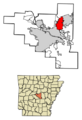
Location of Sherwood in Pulaski County, Arkansas.
See also
 In Spanish: Sherwood (Arkansas) para niños
