
Natural Steps, Arkansas facts for kids
Quick facts for kids
Natural Steps
|
|
|---|---|
 |
|

Location of Natural Steps in Pulaski County, Arkansas.
|
|

Natural Steps, Arkansas
Location in Arkansas
|
|
| Country | United States |
| State | Arkansas |
| County | Pulaski |
| Founded | 1822 |
| Area | |
| • Total | 3.56 sq mi (9.22 km2) |
| • Land | 2.76 sq mi (7.15 km2) |
| • Water | 0.80 sq mi (2.07 km2) |
| Elevation | 446 ft (136 m) |
| Population
(2020)
|
|
| • Total | 413 |
| • Density | 149.64/sq mi (57.78/km2) |
| FIPS code | 05-48680 |
| GNIS feature ID | 2582919 |
Natural Steps is a small community in Pulaski County, Arkansas, United States. It is located about 18 miles (29 km) northwest of Little Rock. The community sits along the southern bank of the Arkansas River, right on Arkansas Highway 300. In 2020, about 413 people lived there.
Today, Natural Steps is a quiet farming community. It has a few local businesses. The famous "natural steps," which are unique rock formations, are still there. They help people on the river know where they are. However, these natural steps are not open for public visits.
Contents
Who Lives in Natural Steps?
| Historical population | |||
|---|---|---|---|
| Census | Pop. | %± | |
| 2010 | 426 | — | |
| 2020 | 413 | −3.1% | |
| U.S. Decennial Census 2010 2020 |
|||
People and Backgrounds (2020)
In 2020, the community of Natural Steps had 413 residents. Here's a look at the different groups of people living there:
| Race / Ethnicity (NH = Non-Hispanic) | Pop 2010 | Pop 2020 | % 2010 | % 2020 |
|---|---|---|---|---|
| White alone (NH) | 398 | 355 | 93.43% | 85.96% |
| Black or African American alone (NH) | 16 | 12 | 3.76% | 2.91% |
| Native American or Alaska Native alone (NH) | 2 | 1 | 0.47% | 0.24% |
| Asian alone (NH) | 2 | 1 | 0.47% | 0.24% |
| Pacific Islander alone (NH) | 0 | 0 | 0.00% | 0.00% |
| Some Other Race alone (NH) | 0 | 3 | 0.00% | 0.73% |
| Mixed Race/Multi-Racial (NH) | 2 | 18 | 0.47% | 4.36% |
| Hispanic or Latino (any race) | 6 | 23 | 1.41% | 5.57% |
| Total | 426 | 413 | 100.00% | 100.00% |
History of Natural Steps
The town of Natural Steps got its name from a special rock formation. These are two parallel sandstone walls, about 20 feet (6 meters) apart. They look like steps going down 51 feet (15.5 meters) to the Arkansas River. These "Natural Steps" were a clear landmark for boatmen and travelers. Starting in 1822, they were a good place for visitors to get off boats and hike to the nearby mountain.

The Natural Steps were first described and drawn by David Dale Owen. He was a geologist who explored Arkansas. In his 1859 report, he wrote about the steps. He noted they looked "wonderfully artificial," like steps built by people. He also said they were a great example of tilted rock layers.

In 1870, Colonel John Navarre Macomb of the United States Army Corps of Engineers mapped the Arkansas River. His maps were for navigation. They included a drawing and the location of the "Natural Steps."
Early Inhabitants
The first people in the Natural Steps area were Native Americans. They lived there possibly as far back as 10,000 years ago. From about 1500 to the late 1700s, the local Native American group was the Quapaw people. Their name means "downstream people."
Naturalist Thomas Nuttall traveled the Arkansas River in 1819. He studied plants and observed the Quapaw and other Native Americans. He wrote about his travels in a journal. Nuttall found few Native Americans living in the Natural Steps area in 1819.

French Explorers
French explorers were known for trading with Native Americans. Many of their canoes or rafts likely stopped in this area. It is said that Jean-Baptiste Bénard de la Harpe spent time here. French explorers coming down the river named the twin peaks of Pinnacle Mountain "Maumelle." This French word means "a woman's breasts."
Steamboat Landing

In the 1800s, Natural Steps was a popular spot for steamboat trips. People would take boats up and down the Arkansas River for picnics. Natural Steps was a good port because the water was deep enough for boats to dock. Many people lived nearby, so there were plenty of passengers and cargo. By 1849, the Arkansas Gazette newspaper reported 15 to 20 steamboat arrivals and departures each week.
On May 19, 1878, the Arkansas Gazette wrote about a successful steamboat trip to Natural Steps. People enjoyed picnics in the shady groves. They also explored and climbed the Natural Steps.

Later, goods like cotton, corn, and firewood were shipped from the steamboat landing at Natural Steps.
.jpg)
The Battle of Palarm
A battle happened near Natural Steps on May 8, 1874. It was part of the Brooks–Baxter War, a conflict in Arkansas. The battle took place on a steamboat called the "Hallie."
The "Hallie" had stopped at Natural Steps to get fuel wood. As it went upstream, shots were fired from rocks on the north bank of the river near Palarm. The soldiers on the "Hallie" fired back. The shooting lasted for about 10 to 15 minutes. A bullet hit the boat's steam pipe, stopping its power. The boat then drifted downriver and landed on the south shore. The boat's captain, a pilot, and one soldier were killed. Several others were wounded.
Ancient Fort Mystery
A manuscript written around 1880 by R.W. Benedict tells of an old fort. Benedict's father settled in Natural Steps around 1820. They found signs of a very old fort where they lived.
In 1821, General John Nicks of the U.S. Army visited. He was on his way to set up Fort Gibson. General Nicks examined the ruins and said they were definitely from an ancient fort. The walls were still visible, and large trees were growing inside them. This showed how old the fort was. The walls were made of rock, and there was a large hole nearby. This hole might have been dug to get materials for the fort or to collect water.
Outside the walls, near the river, many flattened bullets were found. This suggested they had hit the stone walls. Stone hatchets and arrowheads were also found. These items pointed to a big battle fought there long ago. Inside the walls, melted lead and a huge stone axe were discovered. The axe was very unusual and much larger than any seen before. This made people wonder if it came from a faraway land.
Another strange item found was a solid piece of brass. It weighed 5 pounds (2.2 kg) and had unique impressions on its sides. No one could figure out where it came from or what it was for. This brass piece later disappeared mysteriously.
About four miles (6.4 km) away, a man found a lead slab. It was 18 feet (5.5 meters) underground. The slab was smooth, about 8 by 14 inches (20 by 35 cm), and 2 inches (5 cm) thick. It weighed exactly 77 pounds (35 kg). It had marks from an axe and holes in its corners, perhaps for carrying. Nearby, there were ashes and fire-coals. This suggested it was once on the surface, covered by many years of soil.
These discoveries led to many questions. Was this a campsite? Who made the lead slab? Why was it left behind? Benedict believed there was an important fort here that was attacked and destroyed. He wondered if it could be the third lost fort of Hernando de Soto, a famous explorer. However, it is now thought that the fort was likely built by Bernard de la Harpe.
The Great Flood of 1927

In 1927, Natural Steps was hit by the Great Mississippi Flood of 1927. The Arkansas River rose so high that the community was knee-deep in water. The flood reached all the way to Pinnacle Mountain. A photo from that time shows the Natural Steps train depot, the Moreland commissary, and Pinnacle Mountain in the background.
Historic Homes
The Mainard House
The Mainard House was built around 1870. It was one of the first homes in Natural Steps. This tall house faces the river. Before the 1927 flood, the river was much closer to the house. There used to be a cotton gin on the property. Boats would stop there to load and unload cotton. The Mainard House is not open to the public.
The Moreland House
The first Moreland home was built in the 1870s. It was a small shack. Later, it was turned into a barn and garage when a new home was built.
The second Moreland home, known as "The Brick House," was built in the early 1920s. Dr. L.B. Moreland built this two-story house. It had five bedrooms, one bathroom, a living room, a dining room, and a large basement. One room was used as Dr. Moreland's office to see patients.
Dr. Moreland loved fruit trees. He surrounded his home with peach and apple orchards. During the 1927 flood, the basement of the house filled with water. The only way to reach the house was by boat. The photo of the 1927 flood was taken from this house. Sadly, the house was destroyed by a fire in the late 1970s.
Train Depot
Natural Steps once had a small train depot on Maple Avenue. The Memphis and Choctaw Railroad built tracks through the town in 1898. A small station building was put beside the tracks.
Starting in 1907, railroad ties, oak, cypress lumber, and wooden shingles were shipped out. These goods came from depots in Pinnacle and Natural Steps. Several small sawmills operated in the area. The timber industry and farming provided important jobs for early residents. The old depot was destroyed in the early 1900s.
Local Businesses

Moreland Farms is one of the oldest working farms in Natural Steps. The Moreland family has been farming there since the 1870s. When they started, cotton was their main crop. Later, they began growing soybeans. The farm once had a cotton gin, a blacksmith shop, a sawmill, and a commissary along the Rock Island Railroad. These buildings were torn down in 1963. The commissary was destroyed earlier, in the early 1900s. The Moreland family still farms in the area today.
Pinnacle Realty, Inc. started in Natural Steps in 1974. It continues to sell real estate in the area. Their office is located off Highway 300.
Churches in the Community
The Natural Steps Baptist Church was founded in 1913. It was built next to the Natural Steps Cemetery. The original church burned down in 1962. A new church was then built along AR 300, where it stands today.
The Natural Steps Methodist Church was mentioned in the Arkansas Gazette in 1936. This old Methodist Church burned down in the late 1940s. It happened during a volunteer clean-up day at the Natural Steps Cemetery. A spark from one of the fires landed on the church roof, and it was too late to save it.
Cemeteries
- Natural Steps Cemetery (Established September 1, 1861)
- Bailor Cemetery (An African American Cemetery)
Education
Natural Steps is part of the Pulaski County Special School District. Students living here attend Joe T. Robinson Elementary School, Joe T. Robinson Middle School, and Joe T. Robinson High School.
Historic Bridge
In the 1920s, a one-lane truss bridge was built. It was on the old AR 300 and crossed the Little Maumelle River. This bridge is listed on the Historic Bridges of the United States. It is known as the Maumelle River AR 300 Bridge for Pulaski County, Arkansas.

The bridge still stands near Pinnacle Mountain. However, a new bridge built in 1981 made it no longer needed for cars. Today, it is only open for people to walk and fish. It is also part of the 223-mile long Ouachita National Recreation Trail.
Pinnacle Mountain State Park
.jpg)
Pinnacle Mountain State Park was created in 1973. The Fulk family, who owned most of the land, supported making it a state park. The park is just south of Natural Steps on Arkansas Highway 300. Many people visit it for climbing, hiking, and picnicking.
The main feature of the 2,000-acre (8.1 km2) park is Pinnacle Mountain. It rises steeply above the Arkansas River Valley. The mountain is 1,011 feet (308 meters) tall. It is located at the northeast corner of the Ouachita Mountains.
Local Legends
The Search for Gold
In the 1940s, some people in Natural Steps used dynamite to blast the natural steps. They were looking for Confederate gold. A legend said that a Confederate Gunboat was sunk at the natural steps. This was done to keep its gold from the Union Army. The steps were supposed to mark where the gold was hidden. Three Confederate soldiers died when the gunboat exploded. They are buried in the Natural Steps Cemetery. In the late 1800s, someone found a $5 gold coin near the steps. But no gold was found in the 1940s, and the dynamite partly destroyed the steps.
Jesse James' Visit
Another legend comes from Bart Moreland Sr., who was born in Natural Steps in 1899. He said that the famous outlaw Jesse James and his gang once spent the night in Natural Steps. The next day, they supposedly robbed a stagecoach in Benton, on the way to Hot Springs. Bart Sr. heard this story from his parents and others. The old cabin where Jesse James was said to have stayed no longer exists.
The Natural Steps Ghost
A local ghost story tells of a "woman in white." On dark nights in late October, she is seen walking in the Natural Steps Cemetery. She appears in the northeast part of the cemetery, where the old Natural Steps Baptist Church once stood. From there, she walks north into the woods toward the natural steps. When she reaches the steps, she follows them down into the Arkansas River and is not seen again.
The legend says the woman in white is Martha Sanders. She was a young bride who lost her husband, Gustavus Sanders, just days after their wedding in October 1880. Gustavus died from a disease that affected many in the community. Before he died, Gustavus and Martha married at their favorite spot: the top of the natural steps, overlooking the river. Martha was so sad after his funeral that she disappeared. It is believed she jumped into the Arkansas River from the Natural Steps. Some people in the community say they have seen the woman in white. Older generations still share the stories of Gustavus and Martha Sanders.
Images for kids
-
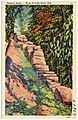
Postcard
-
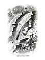
Illustration by David Dale Owen
-
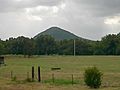
Pinnacle Mountain from the Natural Steps
-
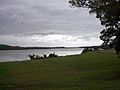
Arkansas River
.jpg)


See also
 In Spanish: Natural Steps (Arkansas) para niños
