
Russellville, Arkansas facts for kids
Quick facts for kids
Russellville, Arkansas
|
|||
|---|---|---|---|

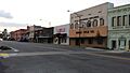
Russellville Downtown Historic District, 2009
|
|||
|
|||

Location of Russellville in Pope County, Arkansas.
|
|||

Russellville, Arkansas
Location in the United States
|
|||
| Country | |||
| State | |||
| County | Pope | ||
| Townships | Dover, Galla, Illinois | ||
| Founded | circa 1842 | ||
| Incorporated | June 7, 1870 | ||
| Named for | Dr. Thomas Russell | ||
| Area | |||
| • City | 28.37 sq mi (73.47 km2) | ||
| • Land | 28.30 sq mi (73.30 km2) | ||
| • Water | 0.06 sq mi (0.17 km2) | ||
| Elevation | 367 ft (112 m) | ||
| Population
(July 1, 2022, estimate)
|
|||
| • City | 29,133 | ||
| • Density | 1,022.54/sq mi (394.80/km2) | ||
| • Metro | 86,666 | ||
| Time zone | UTC-6 (Central (CST)) | ||
| • Summer (DST) | UTC-5 (CDT) | ||
| ZIP code |
72801, 72802
|
||
| Area code(s) | 479 | ||
| FIPS code | 05-61670 | ||
| GNIS feature ID | 2404658 | ||
| Major airport | LIT | ||

Russellville is a city in Pope County, Arkansas, United States. It is the biggest city and the county seat of Pope County. In 2022, about 29,133 people lived there.
Russellville is home to Arkansas Tech University. Close by is Arkansas Nuclear One, which is the only nuclear power plant in Arkansas. The city is located next to Lake Dardanelle and the Arkansas River. It is the main city of the Russellville Micropolitan Statistical Area, which includes all of Pope and Yell counties.
Contents
History of Russellville
Early Settlement
Before it was called Russellville, the area was known as Chactas Prairie. It was a great place to settle because it was on the edge of the Ozark Mountains and near the Arkansas River.
In the 1700s and early 1800s, Osage Indians often visited this valley. Between 1815 and 1828, the land was part of a Cherokee reservation. The Cherokees later moved to Indian Territory (now Oklahoma) in 1828.
The first house in what is now Russellville was built in 1834 by J.C. Holledger. Dr. Thomas Russell bought it the next year. He was one of the first doctors in the area.
In the 1840s, brothers James Madison and Benjamin Shinn opened one of the first stores. Later, in 1852, Benjamin's son, Jacob Shinn, opened a general store. This store was near Dr. Thomas Russell's home.
Jacob Shinn later replaced his wooden store with a brick building in 1876. This building, called the Shinn Building, is still standing today. It was built where two important roads met.
Naming the Town
The town was named Russellville around 1842. It was named after Dr. Thomas Russell, who built the first home there. Some people thought it might be named Shinnville, after the Shinn family who had the first store. However, Jacob Shinn was only a teenager then, so it was more likely named after Dr. Russell. A post office was set up in the early 1840s.
American Civil War and Growth
Many men from Russellville fought in the American Civil War (1861-1865). Some joined state forces, and later many joined Confederate groups. Some local men also formed groups that supported the Union. No big battles happened in Russellville itself.
After the war, the town slowly grew. In the early 1870s, a railroad was built. This helped Russellville grow very quickly. The railroad connected Russellville to other towns like Morrilton and Conway. This made trade much easier.
Russellville's first newspaper, The Herald, started in 1870. By 1876, about 800 people lived in the town. It had many stores, cotton gins, and doctors.
Becoming a City
On June 7, 1870, Russellville officially became an incorporated city. This meant it had its own local government. After this, there was a debate about moving the county seat from Dover to Russellville. In 1887, people voted, and Russellville was chosen as the new county seat.
Formal education started early in the Russellville area. The Russellville Public School District was formed in 1870. By 1876, it was a nine-month school. By 1893, students could graduate after twelve grades.
In the 1800s, most people in the area farmed or harvested timber. By the late 1800s, Russellville became a busy coal-mining area. Cotton was also a profitable crop. Today, there is no coal mining or cotton gins.
20th Century Changes

In 1906, a large fire destroyed almost half of the buildings in the city center. But the town quickly rebuilt most of them within six months.
Arkansas Tech University (ATU) started in 1910 as a high school. Over the years, it added college courses. In 1976, it became Arkansas Tech University.
In 1930, the city council changed the names of the city's streets to make them more organized.
During World War II, many men from Russellville joined the military. After the war, the building of Interstate 40 in 1956 helped Russellville grow even more.
A big economic boost came in 1965 when a dam was built near the Arkansas River. This created Lake Dardanelle, which is now a major tourist spot. The dam also helped improve trade in the area.
In the 1970s, large stores like Wal-Mart opened. This caused the historic downtown area to change. Many old buildings were left to decay or were torn down. Also in the 1970s, Arkansas Nuclear One, Arkansas' only nuclear power plant, was built near the city. This brought more people and jobs to Russellville.
Geography and Climate
Russellville is located at 35°16′42″N 93°8′13″W / 35.27833°N 93.13694°W. The city covers about 28.3 square miles (73.3 square kilometers) of land. It is located on the Arkansas River.
Russellville has a humid subtropical climate. This means it has hot, humid summers and generally mild to cool winters.
| Climate data for Russellville Municipal Airport, Arkansas (1991–2020 normals, extremes 1892–present) | |||||||||||||
|---|---|---|---|---|---|---|---|---|---|---|---|---|---|
| Month | Jan | Feb | Mar | Apr | May | Jun | Jul | Aug | Sep | Oct | Nov | Dec | Year |
| Record high °F (°C) | 82 (28) |
89 (32) |
95 (35) |
100 (38) |
100 (38) |
109 (43) |
113 (45) |
115 (46) |
110 (43) |
99 (37) |
88 (31) |
81 (27) |
115 (46) |
| Mean daily maximum °F (°C) | 50.3 (10.2) |
55.0 (12.8) |
64.3 (17.9) |
72.9 (22.7) |
80.3 (26.8) |
88.2 (31.2) |
92.5 (33.6) |
92.4 (33.6) |
85.6 (29.8) |
74.4 (23.6) |
61.8 (16.6) |
52.2 (11.2) |
72.5 (22.5) |
| Daily mean °F (°C) | 40.0 (4.4) |
44.0 (6.7) |
52.5 (11.4) |
61.0 (16.1) |
69.6 (20.9) |
77.9 (25.5) |
81.8 (27.7) |
81.1 (27.3) |
73.6 (23.1) |
62.1 (16.7) |
50.5 (10.3) |
42.1 (5.6) |
61.4 (16.3) |
| Mean daily minimum °F (°C) | 29.7 (−1.3) |
33.0 (0.6) |
40.8 (4.9) |
49.1 (9.5) |
59.0 (15.0) |
67.6 (19.8) |
71.1 (21.7) |
69.9 (21.1) |
61.7 (16.5) |
49.8 (9.9) |
39.2 (4.0) |
32.0 (0.0) |
50.2 (10.1) |
| Record low °F (°C) | −11 (−24) |
−15 (−26) |
−7 (−22) |
24 (−4) |
32 (0) |
37 (3) |
49 (9) |
47 (8) |
32 (0) |
23 (−5) |
10 (−12) |
−3 (−19) |
−15 (−26) |
| Average precipitation inches (mm) | 3.20 (81) |
3.10 (79) |
4.37 (111) |
4.83 (123) |
4.67 (119) |
3.35 (85) |
3.45 (88) |
3.51 (89) |
3.02 (77) |
4.06 (103) |
4.60 (117) |
4.25 (108) |
46.41 (1,179) |
| Average precipitation days (≥ 0.01 in) | 7.9 | 9.2 | 11.5 | 10.0 | 12.5 | 8.7 | 9.6 | 8.5 | 8.1 | 9.7 | 8.9 | 9.1 | 113.7 |
| Source: NOAA | |||||||||||||
People of Russellville
| Historical population | |||
|---|---|---|---|
| Census | Pop. | %± | |
| 1870 | 240 | — | |
| 1880 | 514 | 114.2% | |
| 1890 | 1,321 | 157.0% | |
| 1900 | 1,832 | 38.7% | |
| 1910 | 2,936 | 60.3% | |
| 1920 | 4,505 | 53.4% | |
| 1930 | 5,628 | 24.9% | |
| 1940 | 5,927 | 5.3% | |
| 1950 | 8,166 | 37.8% | |
| 1960 | 8,921 | 9.2% | |
| 1970 | 11,750 | 31.7% | |
| 1980 | 14,518 | 23.6% | |
| 1990 | 21,260 | 46.4% | |
| 2000 | 23,682 | 11.4% | |
| 2010 | 27,920 | 17.9% | |
| 2020 | 28,940 | 3.7% | |
| U.S. Decennial Census | |||
As of the 2020 United States census, there were 28,940 people living in Russellville. There were 10,184 households and 5,858 families.
Population Details
In 2010, there were 27,920 people in the city. About 83.2% of the people were White. 5.5% were Black or African American. 1.6% were Asian, and 0.7% were Native American. About 11.7% of the population was Hispanic or Latino.
The average household had 2.39 people. The average family had 2.97 people. About 22.6% of the population was under 18 years old. 21.4% were between 18 and 24. The median age was 29.1 years.
Russellville's Economy
Russellville has many manufacturing plants. Companies like Tyson Foods, Inc. have factories here. These plants employ over 8,300 people. More than ten large companies have offices or factories in Russellville.
The city makes many different products. These include frozen dinners, railroad ties, elevator parts, and parking meters. They also make aluminum foil, graphite, and parts for aircraft and cars.
Local Media
Russellville's local newspaper is The Courier. It is published six days a week.
ABOUT the River Valley is a monthly magazine. It is based in Russellville and covers five counties.
You can watch TV stations from Little Rock or Fort Smith in Russellville. These include CBS, FOX, NBC, and ABC channels.
Several radio stations serve the city. Some are licensed to Russellville, like KWKK-FM 100.9. Others are licensed to nearby towns but have studios in Russellville. There are also two non-commercial radio stations.
Fun Things to Do
Russellville is known for its local music and art scene. The downtown area is historic and interesting.
The Downtown Art Walk happens four times a year. People can enjoy live music, food, and art. They can also buy art and connect with the community.
Russellville is a great place for sports and fishing. This is because of its location on Lake Dardanelle. The city is also close to Mt. Nebo and Lake Dardanelle State Park. Many people come to Russellville for work and fun.
Balloons over Russellville is a hot air balloon festival. It takes place every May at the Russellville Soccer Complex. The event has hot air balloons, helicopter rides, and live music. It also hosts the Arkansas State Championship Chainsaw Carving Competition.
The Pope County Fairgrounds hosts many events. These include horse racing, fairs, and conventions. At the end of every summer, the annual Pope County Fair takes place. It has rides, live music, animals, and games. Over 50,000 people visit the fair each year.
Education in Russellville
Russellville is home to Arkansas Tech University (ATU). It was founded in 1909. In 2014, over 12,000 students attended ATU.
The city is part of the Russellville School District. This district operates Russellville High School.
Russellville also has an Alternative Learning Center. This center helps students who are struggling in school. It gives them more personal attention. It also helps high school dropouts earn their diplomas or GEDs.
Famous People from Russellville
Many notable people have connections to Russellville:
- Mabel Washbourne Anderson (1863–1949) was a Cherokee writer.
- Scott Bradley, who wrote music for Tom and Jerry cartoons, was from Russellville.
- Natalie Canerday, an actress, graduated from Russellville High School.
- Jeff Davis, a former U.S. Senator and Governor of Arkansas, lived in Russellville.
- Elizabeth Gracen was crowned Miss America in 1982. She graduated from Russellville High School.
- Brooks Hays started his law practice in Russellville. He later became a U.S. representative.
- Greg Horne, an NFL punter, graduated from Russellville High School.
- Jimmy Lile was a famous knife maker. He was known for his work in the Rambo movies.
- Eddie Meador, an NFL player, graduated from Russellville High School.
- Matt Riviera, a professional wrestler, was born and raised in Russellville.
- Corliss Williamson, an NBA player, graduated from Russellville High School.
- Steve Womack, a United States congressman, was born in Russellville.
Gallery
-
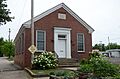
Public Library Annex (Built in 1936-37; image: 30 May 2016 )
-
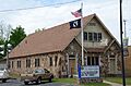
American Legion Hut (Built in 1934; Image: April 18, 2015)
-
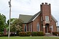
Christian Church (Built in 1885-86; Image: April 18, 2015)
-
Confederate Mothers Memorial (Donated in 1921; Image: April 18, 2015)
-
Main Street, August 21, 2013
-
Pope County Courthouse (built 1931), August 21, 2013


See also
 In Spanish: Russellville (Arkansas) para niños
