Yell County, Arkansas facts for kids
Quick facts for kids
Yell County
|
|
|---|---|

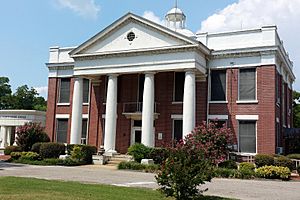
Yell County Courthouse, Dardanelle
|
|

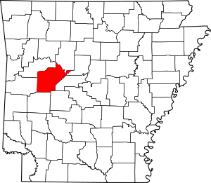
Location within the U.S. state of Arkansas
|
|
 Arkansas's location within the U.S. |
|
| Country | |
| State | |
| Founded | December 5, 1840 |
| Named for | Archibald Yell |
| Seat | Danville (western district); Dardanelle (eastern district) |
| Largest city | Dardanelle |
| Area | |
| • Total | 949 sq mi (2,460 km2) |
| • Land | 930 sq mi (2,400 km2) |
| • Water | 19 sq mi (50 km2) 2.0%% |
| Population
(2020)
|
|
| • Total | 20,263 |
| • Estimate
(2021)
|
20,155 |
| • Density | 21.352/sq mi (8.244/km2) |
| Time zone | UTC−6 (Central) |
| • Summer (DST) | UTC−5 (CDT) |
| Congressional district | 4th |
Yell County is a county located in the state of Arkansas in the United States. In 2020, about 20,263 people lived there. Yell County is special because it has two county seats: Dardanelle and Danville.
The county was created on December 5, 1840. It was formed from parts of Scott and Pope counties. Yell County is named after Archibald Yell. He was the first person from Arkansas to serve in the United States House of Representatives. He also became the second governor of Arkansas. Archibald Yell sadly died fighting in the Mexican–American War.
Yell County is part of the Russellville area. It is also a "dry county," which means that selling alcohol is not allowed there.
Contents
History
Native Americans lived in the area that is now Yell County for thousands of years. They used the rich land near the Arkansas River for hunting and later for farming. Between 1775 and 1786, many Cherokee people moved from Georgia to the Arkansas River Valley, including parts of Yell County. In 1815, a large Cherokee reservation was set up across the Arkansas River to encourage more Cherokee to move there.
The first European settlers arrived in Yell County around 1819. James Carden built a house near Cherokee farms in the Dardanelle Bottoms. This area is where the Arkansas and Petit Jean rivers meet. In the 1820s, land south of the Arkansas River was given to the Choctaw people. However, both white settlers and Cherokee people continued to move into the area, leading to competition for the best land.
In June 1823, a meeting happened between Cherokee chiefs and the acting governor, Robert Crittenden. They met under two large oak trees. People once thought this meeting created a treaty, but the governor did not have the power to make treaties. The meeting ended with no agreement.
Some Cherokee families stayed on their farms south of the river. They were sometimes called "Black Dutch" and married into the white settler families.
In 1830, the United States Congress passed the Indian Removal Act. This law forced many Native American tribes to move from their homes. Cherokee, Muskogee (Creek), and Seminole people were forced to travel through Yell County on the Trail of Tears. They were moved to what is now Oklahoma.
During the American Civil War, Union forces took control of Yell County in October 1862. In January 1865, about 1,500 Confederate soldiers tried to take Dardanelle back. They failed after a four-hour battle. A soldier named William Ellis received a Medal of Honor for bravely holding his position even after being wounded many times.
Geography
Yell County covers about 949 square miles. Most of this area, 930 square miles, is land. The remaining 19 square miles (about 2%) is water.
Nearby Counties
Yell County shares borders with these counties:
- Pope County (north)
- Conway County (northeast)
- Perry County (east)
- Garland County (southeast)
- Montgomery County (south)
- Scott County (west)
- Logan County (northwest)
Protected Natural Areas
Parts of these national protected areas are found in Yell County:
- Holla Bend National Wildlife Refuge
- Ouachita National Forest
- Ozark National Forest
Demographics
| Historical population | |||
|---|---|---|---|
| Census | Pop. | %± | |
| 1850 | 3,341 | — | |
| 1860 | 6,333 | 89.6% | |
| 1870 | 8,048 | 27.1% | |
| 1880 | 13,852 | 72.1% | |
| 1890 | 18,015 | 30.1% | |
| 1900 | 22,750 | 26.3% | |
| 1910 | 26,323 | 15.7% | |
| 1920 | 25,655 | −2.5% | |
| 1930 | 21,313 | −16.9% | |
| 1940 | 20,970 | −1.6% | |
| 1950 | 14,057 | −33.0% | |
| 1960 | 11,940 | −15.1% | |
| 1970 | 14,208 | 19.0% | |
| 1980 | 17,026 | 19.8% | |
| 1990 | 17,759 | 4.3% | |
| 2000 | 21,139 | 19.0% | |
| 2010 | 22,185 | 4.9% | |
| 2020 | 20,263 | −8.7% | |
| 2023 (est.) | 20,044 | −9.7% | |
| U.S. Decennial Census 1790–1960 1900–1990 1990–2000 2010 2020 |
|||
2020 Census Information
In 2020, there were 20,263 people living in Yell County. There were 7,503 households and 5,542 families.
Here's a look at the different groups of people living in Yell County in 2020:
| Group | Number of People | Percentage of Total |
|---|---|---|
| White (not Hispanic) | 14,710 | 72.6% |
| Black or African American (not Hispanic) | 226 | 1.12% |
| Native American | 111 | 0.55% |
| Asian | 202 | 1.0% |
| Pacific Islander | 11 | 0.05% |
| Other/Mixed | 799 | 3.94% |
| Hispanic or Latino | 4,204 | 20.75% |
Culture and Contemporary Life
Yell County has many historic homes, buildings, and monuments. These help preserve the area's history and culture. The Dardanelle Commercial Historic District protects the old business center of Dardanelle along the Arkansas River. The Mt. Nebo State Park Cabins Historic District has ten cabins built in the 1930s by the Civilian Conservation Corps. The county also has seven homes, three churches, and two bridges listed on the National Register of Historic Places.
When settlers first arrived, the different types of land in Yell County created different ways of life. People living in the fertile "lowlands" near the river had productive farms. Those in the "uplands" on the steeper mountain soil often farmed just enough to feed their families. As Dardanelle grew, some large landowners moved to town. They managed their farms from fancy homes, similar to how things were in other parts of Arkansas. This led to a difference between town life and country life, often based on how much money people had.
Over time, as farming methods changed and Arkansas developed, a wealthy group of people grew in Dardanelle. They became important in the county's society, politics, and economy. This group often kept to themselves, with their own social events. Some would spend summers on Mount Nebo, enjoying the cool mountain air. Yell County did not have much industry like other parts of the country. Instead, its economy continued to rely on agriculture, but it changed to fit the times after the Civil War.
Education
Children in Yell County attend public schools run by four school districts:
- Danville School District
- Dardanelle School District
- Two Rivers School District (formed in 2004 from several smaller districts)
- Western Yell County School District (formed in 1985 from two smaller districts)
Former School Districts
Some school districts that used to exist in Yell County include:
- Fourche Valley School District
- Ola School District
- Perry–Casa School District
- Plainview-Rover School District
- Havana School District
- Belleville School District
- Carden Bottoms School District
Public Libraries
The Arkansas River Valley Regional Library System has its main office in Dardanelle. It serves several counties and has one main library and six smaller branch libraries. The Yell County Library in Danville is one of these branch libraries.
Communities
Cities
- Belleville
- Danville (one of the county seats)
- Dardanelle (one of the county seats)
- Havana
- Ola
- Plainview
Town
Census-Designated Places
These are areas that are like towns but are not officially incorporated:
Unincorporated Communities
These are smaller communities that are not officially part of a city or town:
- Alpha
- Aly
- Ard
- Bluffton
- Briggsville
- Chickalah
- Goodie Gorn Creek
- Gravelly
- Mount George
- New Neely
- Onyx
- Pleasant Hill
- Shark
- Sulphur Springs
- Wing
Townships
Townships in Arkansas are the divisions of a county. Each township includes unincorporated areas; some may have incorporated cities or towns within part of their boundaries. Arkansas townships have limited purposes in modern times. However, the United States Census does list Arkansas population based on townships (sometimes referred to as "county subdivisions" or "minor civil divisions"). Townships are also of value for historical purposes in terms of genealogical research. Each town or city is within one or more townships in an Arkansas county based on census maps and publications. The townships of Yell County are listed below; listed in parentheses are the cities, towns, and/or census-designated places that are fully or partially inside the township.
- Birta
- Bluffton
- Briggsville
- Centerville
- Chula
- Compton
- Crawford
- Danville (Corinth, Danville)
- Dardanelle (Dardanelle)
- Dutch Creek
- Ferguson (Belleville)
- Galla Rock
- Gilkey
- Gravelly Hill
- Herring
- Ions Creek
- Lamar (Plainview)
- Magazine
- Mason
- Mountain
- Prairie
- Richland
- Riley (Havana)
- Rover
- Sulphur Springs
- Ward (Ola)
- Waveland
Infrastructure
Major Highways
These are the main roads that go through Yell County:
Notable People
Many interesting people have connections to Yell County:
- Ray R. Allen (1920–2010), a public official in Louisiana, was born here.
- John Daly, a famous professional golfer.
- Arthur Hunnicutt, an actor known for Western movies.
- Kelly Ring, a news anchor.
- Johnny Sain, a Major League Baseball player.
- William L. Spicer, a Republican state chairman, was born in Yell County.
- Cousins Jim Walkup (left-handed pitcher) and Jim Walkup (right-handed pitcher), both MLB pitchers.
- James Lee Witt, a former director of FEMA.
- Henry C. Bruton, a Rear Admiral in the United States Navy, born in Belleville in 1905.
- Jacob Lofland, an American actor.
- Timothy Balarabe, a jazz musician.
Images for kids
See also
 In Spanish: Condado de Yell para niños
 | Calvin Brent |
 | Walter T. Bailey |
 | Martha Cassell Thompson |
 | Alberta Jeannette Cassell |


