
Dardanelle, Arkansas facts for kids
Quick facts for kids
Dardanelle, Arkansas
|
|
|---|---|

Front St. Downtown Dardanelle. January 2020
|
|
| Motto(s):
"Where history & hospitality reside"
|
|

Location of Dardanelle in Yell County, Arkansas.
|
|
| Country | United States |
| State | Arkansas |
| County | Yell |
| Area | |
| • Total | 3.64 sq mi (9.44 km2) |
| • Land | 3.64 sq mi (9.44 km2) |
| • Water | 0.00 sq mi (0.00 km2) |
| Elevation | 328 ft (100 m) |
| Population
(2020)
|
|
| • Total | 4,517 |
| • Density | 1,239.57/sq mi (478.56/km2) |
| Time zone | UTC-6 (Central (CST)) |
| • Summer (DST) | UTC-5 (CDT) |
| ZIP code |
72834
|
| Area code(s) | 479 |
| FIPS code | 05-17380 |
| GNIS feature ID | 2404187 |
| Website | City of Dardanelle Arkansas |
Dardanelle is a city in Yell County, Arkansas, United States. It is one of two county seats for Yell County, sharing the title with Danville. In 2020, about 4,517 people lived there. The city is also close to Lake Dardanelle. Dardanelle is part of the Russellville area.
Contents
History of Dardanelle

Dardanelle is one of the oldest cities in Arkansas. It officially became a city in 1855. However, people had settled in the area much earlier, starting as a river town in the mid-1700s.
Important Treaties and River Life
A very important event, the Treaty of Council Oaks, was signed here on June 24, 1823. It happened under two huge oak trees that were hundreds of years old. During this treaty, the Cherokee people gave up their land in Arkansas south of the Arkansas River. One of these historic trees is still standing today and is part of a city park.
Because Dardanelle is located right on the Arkansas River, it was a very busy town in the 1800s. Many boats, like steamboats, passed through the town every year. Dardanelle was a major center for transportation and business. It was known as a marketplace for goods like cotton.
A Place for New Beginnings
Dardanelle has always been a place where many new people have come to live. In the late 1700s and early 1800s, many families from Czech and German backgrounds moved to the town. Their influence can still be seen today. Even now, Dardanelle has a large Hispanic population, with over 39% of its residents being Hispanic in 2020.
Modern Developments
In the late 1990s, Merritt Park opened in Dardanelle. It's a modern park with great baseball fields, a playground, soccer fields, and basketball courts. There's also a walking and jogging trail. The Dardanelle Community Center, which offers many services, opened around the same time.
A pontoon bridge was built between Dardanelle and Russellville in the late 1800s. It was over 2,200 feet long, making it the longest pontoon bridge ever built over a moving river. This bridge was sometimes washed away by floods during its nearly 40 years of use.
The Dardanelle Lock & Dam was built in the 1960s. It helped create Lake Dardanelle. This dam produces electricity and helps control river traffic on the Arkansas River.
In 2019, during big floods on the Arkansas River, a levee (a protective wall) near Dardanelle broke. Water came very close to homes and schools, but thankfully, it went down before causing major damage.
Geography and Climate
Dardanelle covers about 3.1 square miles (8.0 km²) of land.
Weather in Dardanelle
Dardanelle has a climate with warm summers and mild winters. The hottest month is usually July, and the coldest is January. The area gets a good amount of rain throughout the year.
Population Information
| Historical population | |||
|---|---|---|---|
| Census | Pop. | %± | |
| 1860 | 299 | — | |
| 1870 | 926 | 209.7% | |
| 1880 | 748 | −19.2% | |
| 1890 | 1,456 | 94.7% | |
| 1900 | 1,602 | 10.0% | |
| 1910 | 1,757 | 9.7% | |
| 1920 | 1,835 | 4.4% | |
| 1930 | 1,832 | −0.2% | |
| 1940 | 1,807 | −1.4% | |
| 1950 | 1,772 | −1.9% | |
| 1960 | 2,098 | 18.4% | |
| 1970 | 3,297 | 57.1% | |
| 1980 | 3,621 | 9.8% | |
| 1990 | 3,722 | 2.8% | |
| 2000 | 4,228 | 13.6% | |
| 2010 | 4,745 | 12.2% | |
| 2020 | 4,517 | −4.8% | |
| U.S. Decennial Census 2014 Estimate |
|||
The population of Dardanelle has changed over time. In 1860, there were 299 people, and by 2020, the population grew to 4,517.
Economy and Jobs
Some of the biggest employers in Dardanelle include Tyson Foods, Walmart Supercenter, and the Dardanelle Nursing and Rehabilitation Center. The Dardanelle School System, the City Government, and Chambers Bank also provide many jobs.
Dardanelle is home to the Dardanelle Post-Dispatch newspaper. It started in 1853 and is said to be the oldest weekly newspaper in Arkansas.
Arts and Culture

.jpg)

Fun Places to Visit
There are several interesting places to see in and around Dardanelle:
- The Yell County Courthouse, which is a historic building.
- Dardanelle Rock, a natural landmark.
- Highway 22, also known as the "True Grit Trail." This highway was named after the famous movie True Grit. In the movie, a character named Maddie was from Dardanelle.
Parks and Outdoor Fun
Dardanelle offers many places for outdoor activities:
- Lake Dardanelle is a popular spot for fishing and boating.
- Mount Nebo and Mount Nebo State Park offer beautiful views and hiking trails.
- Holla Bend National Wildlife Refuge is a great place to see wildlife.
- Dana Merritt Park has sports fields and playgrounds.
- Veterans' Memorial Riverfront Park is a nice place to relax by the river.
- Council Oaks Park and Historic Site marks the spot of the historic treaty.
Education in Dardanelle
Public Library
The Arkansas River Valley Regional Library system has its main library in Dardanelle. This library, located on North Front Street, and its branch libraries offer books, magazines, and other media for everyone in the area.
Schools
Students in Dardanelle attend public schools run by the Dardanelle School District. Students go all the way through to Dardanelle High School.
Transportation
The Dardanelle and Russellville Railroad, or "D&R," is a short train line that connects Dardanelle to Russellville. Several highways, including Highways 7, 22, 27, and 28, pass through Dardanelle. Highway 7 is a scenic route that goes from the Buffalo River in the north to Hot Springs in the south.
Sports
- The Lion's Den Golf Course is a place where people can play golf.
- In 1924, Dardanelle had its own minor league baseball team called the Dardanelle White Sox. They played in a league and made it to the finals, but they lost to the Russellville Miners.
Famous People from Dardanelle
- Bonnie Brown: A singer from the country music group the Browns.
- Jim R. Caldwell: The first Republican to serve in the Arkansas State Senate in the 20th century.
- Johnny Carpenter: An American film actor, writer, and producer.
- Tom Cotton: A U.S. Senator from Arkansas.
- John Daly: A famous golfer who lived in Dardanelle as a child.
- Orval Lee Jaggers: A Christian minister and writer.
- James Lee Witt: A former director of the Federal Emergency Management Agency (FEMA).
Images for kids
-
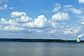
View of Lake Dardanelle, with the power plant at Arkansas Nuclear One visible in the background.

See also
 In Spanish: Dardanelle para niños
