
Arkansas Highway 22 facts for kids
Quick facts for kids
|
||||
|---|---|---|---|---|
 |
||||
| Route information | ||||
| Maintained by AHTD | ||||
| Length | 75.60 mi (121.67 km) | |||
| Existed | 1926–present | |||
| Major junctions | ||||
| West end | ||||
| East end | ||||
| Location | ||||
| Counties: | Sebastian, Franklin, Logan, Yell | |||
| Highway system | ||||
| Arkansas Highway System Interstates • US • State Business • Spurs • Scenic
|
||||

Highway 22 (also called AR 22 or Hwy. 22) is an important road in Arkansas. It runs from west to east through the Arkansas River Valley. This highway is about 75.60 miles (121.67 km) long. It starts in Fort Smith and ends in Dardanelle.
Highway 22 is special because it follows part of the old Butterfield Trail, which was a famous stagecoach route long ago. It was one of the first state highways in Arkansas, created in 1926. Today, it's also known as the "True Grit Trail."
Contents
Exploring Highway 22: Your Journey East
Highway 22 begins in Fort Smith. From there, it heads east. It crosses I-540 and US 71. It also passes near the future I-49 highway.
Part of Highway 22 in Fort Smith follows the historic Trail of Tears. This is where the Seminole people traveled a long time ago. The highway then runs alongside AR 255 through Fort Chaffee Maneuver Training Center.
As you continue east, Highway 22 meets AR 96. Then it enters Charleston. Here, it connects with AR 217. The historic Butterfield Trail also follows Highway 22 from Charleston all the way to Dardanelle.
Further east, the highway crosses AR 41 in Branch. You'll also pass County Line High School between Branch and Ratcliff.

In Caulksville, Highway 22 meets AR 23. Moving into Paris, it connects with AR 109, AR 288, and AR 309.
Highway 22, AR 109, and AR 288 run together for a while. In Subiaco, AR 288 leaves the route. Highway 22 then crosses AR 197. AR 109 also separates from Highway 22 in Midway.
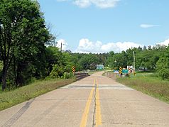
Finally, Highway 22 continues alone through New Blaine and Delaware. It ends in Dardanelle at AR 7. The road is generally straight and in good condition.
History of Highway 22
Before Highway 22 existed, its path was used by the Butterfield Trail. This was a famous stagecoach route. It carried mail and people from Memphis to Fort Smith. From Fort Smith, the trail split, going to San Francisco or St. Louis. The Butterfield Trail operated from 1858 to 1861.
Highway 22 was one of the very first state highways in Arkansas. It was created in 1926. Its route from Fort Smith to Dardanelle has stayed mostly the same since then.
In 2015, Highway 22 was connected to the future I-49 in Barling. In 2019, plans were made to improve parts of Highway 22 between Fort Smith and Charleston.
On November 14, 2019, the highway was officially named the "True Grit Trail." This name comes from the famous 1968 novel True Grit by Charles Portis. In the book, the main character, Mattie Ross, travels along Highway 22 from Dardanelle to Fort Smith.
Historic Sections of Highway 22
Some original parts of Highway 22 are still around today. They are listed on the National Register of Historic Places. This means they are important historical sites. These old road sections help us understand how highways were built in Arkansas between 1910 and 1965.
Barling Segment
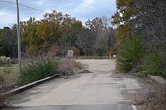
The Old Arkansas 22, Barling Segment is a historic part of the road in Barling, Arkansas. It's now called Mayo Drive. This section is about 0.5 miles (0.8 km) long and made of concrete. It was built in 1928. It's the longest piece of the early Highway 22 that still exists.
New Blaine Segment
Old Arkansas Highway 22 near New Blaine is another historic section. It's an S-shaped asphalt road, about 1.5 miles (2.4 km) long. It was built in 1930. This part of the road was replaced by the current highway in the 1960s. Today, it's part of Arkansas Highway 197 and still helps people get to the town center.
Yell County Segment
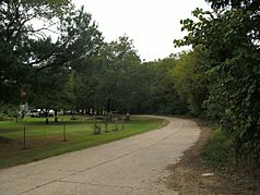
In Yell County, west of Dardanelle, there's a small piece of the original highway left. It's called County Road 906 (CR 906). This concrete section is about 0.25 miles (0.4 km) long and 18 feet (5.5 m) wide. It was added to the National Register of Historic Places in 2008.
Major intersections
| County | Location | Mile | Roads intersected | Notes | |
|---|---|---|---|---|---|
| Sebastian | Fort Smith | 0.00 | 0.00 | ||
| 3.67 | 5.91 | I-540/I-49 exit 8 | |||
| Barling | 7.07 | 11.38 | |||
| 8.07 | 12.99 | ||||
| 8.38 | 13.49 | ||||
| 8.65 | 13.92 | Opened to traffic and signed as AR 549, northbound segment into Crawford County unbuilt; future I-49 exit 193 | |||
| Central City | 11.00 | 17.70 | |||
| Diamond Grove | 14.04 | 22.60 | |||
| | 16.33 | 26.28 | |||
| | 20.20 | 32.51 | |||
| Franklin | Charleston | 23.58 | 37.95 | ||
| 24.33 | 39.16 | ||||
| Branch | 29.21– 29.81 |
47.01– 47.97 |
Officially designated exception | ||
| Logan | Ratcliff | 32.61 | 52.48 | ||
| Caulksville | 33.81 | 54.41 | |||
| Paris | 39.69 | 63.87 | |||
| 41.40 | 66.63 | Western end of AR 109 concurrency | |||
| Subiaco | 46.79 | 75.30 | |||
| Midway | 52.99 | 85.28 | Eastern end of AR 109 concurrency | ||
| New Blaine | 59.69 | 96.06 | |||
| Delaware | 66.00 | 106.22 | |||
| Yell | Dardanelle | 75.29 | 121.17 | ||
| 75.60 | 121.67 | ||||
| 1.000 mi = 1.609 km; 1.000 km = 0.621 mi | |||||
