
Garland County, Arkansas facts for kids
Quick facts for kids
Garland County
|
||
|---|---|---|

Garland County Courthouse
|
||
|
||

Location within the U.S. state of Arkansas
|
||
 Arkansas's location within the U.S. |
||
| Country | ||
| State | ||
| Founded | April 5, 1873 | |
| Named for | Augustus Hill Garland | |
| Seat | Hot Springs | |
| Largest city | Hot Springs | |
| Area | ||
| • Total | 735 sq mi (1,900 km2) | |
| • Land | 678 sq mi (1,760 km2) | |
| • Water | 57 sq mi (150 km2) 7.7%% | |
| Population
(2020)
|
||
| • Total | 100,180 | |
| • Density | 136.30/sq mi (52.63/km2) | |
| Time zone | UTC−6 (Central) | |
| • Summer (DST) | UTC−5 (CDT) | |
| Congressional district | 4th | |

Garland County is a county in Arkansas, a state in the United States. In 2020, about 100,180 people lived here. The main city and county seat is Hot Springs.
Garland County is part of the Hot Springs, Arkansas area. It is home to Hot Springs National Park. This is the only national park in Arkansas. It was also the first place in the U.S. to be protected by federal law. President Andrew Jackson helped pass a law in 1832 to save this area. This happened even before Arkansas became a state!

Contents
History of Garland County
Early Inhabitants and Explorers
Long ago, the Natchitoches people lived in this area. They often visited the hot springs because they believed the waters had healing powers. Their ancestors had been coming to these springs for thousands of years.
In 1803, the U.S. bought the Louisiana Territory from France. President Thomas Jefferson then asked William Dunbar to explore this new land. Dunbar was a scientist and a farmer from Mississippi. He led a small group of soldiers and a chemist named George Hunter. They went to the Ouachita Mountains to study the land. They wanted to learn about the Native American tribes, minerals, and springs.
In December 1804, they reached Hot Springs. They found a simple cabin there. Visitors used this cabin when they came to the springs.
First European Settlers
The first European-American settler was Jean Pierre Emanuel Prudhomme. He was from a French family. Prudhomme owned a large farm and was very sick. He came to the springs hoping to get better. In 1807, he built the first permanent European house near the springs. He lived there for two years.
Two trappers from Alabama, Isaac Cates and John Percival, joined him. Percival thought the area had great potential. He built log cabins to rent to people visiting the springs.
In 1828, Ludovicus Belding came with his family. After a few months, they built a small hotel. This hotel was for people who came to enjoy the hot springs.
Protecting the Hot Springs
In 1832, President Andrew Jackson signed a law. This law protected the hot springs area for everyone to enjoy. It was called Hot Springs Reservation. This was the first time the U.S. government protected land for public use. It happened four years before Arkansas became a state in 1836.
Later, there was a disagreement over who owned the land. The U.S. Supreme Court decided in 1877 that the federal government owned it. In 1921, the area officially became Hot Springs National Park. The National Park Service now takes care of it.
Forming Garland County
Garland County became Arkansas's 68th county. It was formed on April 5, 1873. This was during the Reconstruction era, a time after the Civil War. Parts of Hot Spring, Montgomery, and Saline counties were used to create it.
The county was named after Augustus Hill Garland. He was the eleventh governor of Arkansas. Garland County is the only county in the United States with this name.
Geography
Garland County covers about 735 square miles. About 678 square miles of this is land. The other 57 square miles (about 7.7%) is water.
How to Get Around (Transit)
- Hot Springs Intracity Transit
Main Roads (Major Highways)
 U.S. Highway 70
 U.S. Highway 270
 Highway 5
 Highway 7
 Highway 88
Neighboring Counties (Adjacent Counties)
- Perry County (north)
- Saline County (east)
- Hot Spring County (south)
- Montgomery County (west)
- Yell County (northwest)
Protected Natural Areas (National Protected Areas)
- Hot Springs National Park
- Ouachita National Forest (part of it)
Population (Demographics)
| Historical population | |||
|---|---|---|---|
| Census | Pop. | %± | |
| 1880 | 9,023 | — | |
| 1890 | 15,328 | 69.9% | |
| 1900 | 18,773 | 22.5% | |
| 1910 | 27,271 | 45.3% | |
| 1920 | 25,785 | −5.4% | |
| 1930 | 36,031 | 39.7% | |
| 1940 | 41,664 | 15.6% | |
| 1950 | 47,102 | 13.1% | |
| 1960 | 46,697 | −0.9% | |
| 1970 | 54,131 | 15.9% | |
| 1980 | 70,531 | 30.3% | |
| 1990 | 73,397 | 4.1% | |
| 2000 | 88,068 | 20.0% | |
| 2010 | 96,024 | 9.0% | |
| 2020 | 100,180 | 4.3% | |
| 2023 (est.) | 99,784 | 3.9% | |
| U.S. Decennial Census 1790–1960 1900–1990 1990–2000 2010 |
|||
In 2020, Garland County had 100,180 people living there. There were 41,743 households and 26,006 families.
Most people in Garland County are White (about 77.1%). About 8.02% are Black or African American. Other groups include Native American, Asian, and Pacific Islander people. About 7.03% of the population is Hispanic or Latino.
Communities
Cities
- Hot Springs (the main city)
- Mountain Pine
Towns
Census-Designated Places (CDPs)
Small Villages (Unincorporated Communities)
Images for kids
-
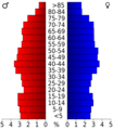
This chart shows the age groups in Garland County.
-
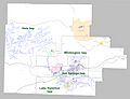
A map showing the different townships within Garland County.


See also
 In Spanish: Condado de Garland para niños
