
Hot Springs National Park facts for kids
Quick facts for kids Hot Springs National Park |
|
|---|---|

Hot Springs National Park
Location in Arkansas

Hot Springs National Park
Location in the United States
|
|
| Location | Garland County, Arkansas, United States |
| Nearest city | Hot Springs |
| Area | 5,550 acres (22.5 km2) |
| Established | April 20, 1832 (designated as a national park on March 4, 1921) |
| Visitors | 2,646,133 (in 2022) |
Hot Springs National Park is a special national park in central Garland County, Arkansas, right next to the city of Hot Springs. It was first protected by the United States government on April 20, 1832. This happened even before the idea of "national parks" existed! It was the first time land was set aside by the federal government just for people to enjoy and relax.
For centuries, people have believed that the hot spring water here has special healing powers. Native American tribes shared legends about these waters. After the government protected the area, the nearby city grew into a popular place for spas and relaxation. In the early 1900s, the city of Hot Springs was known for many exciting things. These included Major League Baseball spring training and horse racing at Oaklawn Park. Famous people like the 42nd President Bill Clinton also have connections to the area.
The area officially became a national park on March 4, 1921. For many years, it was the smallest national park in the United States. In April 2010, Hot Springs National Park was the first park to be featured on its own US quarter. This was part of the America the Beautiful Quarters coin series.
The hot springs flow from the western side of Hot Springs Mountain. This mountain is part of the Ouachita Mountain range. The park carefully manages these springs. This ensures that clean, hot water is always available for everyone to use. The mountains in the park are also protected. This helps keep the natural water system working perfectly for the springs.
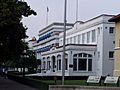
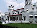
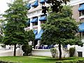
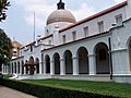
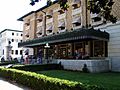
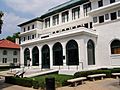
The park includes parts of downtown Hot Springs. This makes it one of the easiest national parks to visit. You can find many hiking trails and places to camp. You can also bathe in the spring water at special facilities, though there is an extra cost. The famous Bathhouse Row is a National Historic Landmark District. It has the most impressive collection of historic bathhouses in North America. These buildings show amazing Gilded Age architecture. The Fordyce Bathhouse on the row is now the park's visitor center. As of 2015, the Buckstaff and Quapaw are the only bathhouses still open for bathing. Other buildings on the row are being restored or used for different purposes.
Contents
Discovering and Protecting the Springs


For thousands of years, many different Native American tribes visited this area. They called it the "Valley of the Vapors." In 1541, Hernando de Soto was the first European explorer to see the springs. Native American tribes had gathered here for over 8,000 years. They believed in the healing power of the warm waters. Around the 1700s, the Caddo people lived here. Later, the Choctaw, Cherokee, and other tribes from the Southeast also visited. These tribes often agreed to set aside their weapons and share the healing waters peacefully. The Quapaw people, who lived near the Arkansas River, also came to the springs.

In 1673, Father Marquette and Jolliet explored this region. They claimed it for France. Later, in 1763, the Treaty of Paris 1763 gave the land to Spain. But in 1800, France took control again. Then, in 1803, the United States bought the land as part of the Louisiana Purchase.
In 1804, President Thomas Jefferson asked William Dunbar and George Hunter to explore the Ouachita Mountains and the springs. They studied the local people, plants, and animals. They found only a few simple cabins used by visitors seeking the healing waters. In 1807, Jean Emmanual Prudhomme became the first European-American to settle in what is now Hot Springs. He felt much better after two years of bathing in the hot water. Soon after, other settlers built more cabins for visitors.
On August 24, 1818, the Quapaw Indians gave the land around the hot springs to the United States. This was part of a treaty. In 1820, the Arkansas Territorial Legislature asked for the springs and mountains to be protected by the federal government. Twelve years later, in 1832, the 22nd United States Congress created the national reservation. This made Hot Springs the first area in the country to receive federal protection for its thermal waters. The Hot Springs Reservation was officially set aside for public use as a park on June 16, 1880.
Becoming a National Park


In 1921, a law changed the name from Hot Springs Reservation to Hot Springs National Park. The government bought more land, making the park larger. It grew to include Hot Springs Mountain, North Mountain, West Mountain, Sugarloaf Mountain, and Whittington Lake Park. The park eventually expanded to about 5,839 acres (2,385 hectares).
The springs are located at the base of Hot Springs Mountain. They produce over half a million gallons of hot water every day! This hot water is sent to the different bathhouses. The money earned from these bathhouses helps support the U.S. Treasury. The park also has many miles of roads and trails for exploring the mountains. It is open all year round.
The very first bathhouses were simple huts and cabins. They were built over holes in the rocks to catch the hot water. Over time, people built more fancy bathing places. These used wooden channels to bring water from the hillside springs to bathhouses along Hot Springs Creek. Some of the natural rock formations were even dug out to make space for these buildings.
After the federal government started managing the area in 1877, many improvements were made. The creek was covered with stone arches, and a wide street was built on top. All unauthorized settlers were moved, and the area was cleaned up. A central plumbing system was also started, which was finished around 1890. By 1950, central cooling towers were added. These towers made sure the spring water was always a safe temperature for bathers.
The park also has a public campground called Gulpha Gorge. It is about 2 miles (3 km) from downtown Hot Springs.
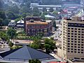
The City of Hot Springs

The city of Hot Springs, which became a city in 1851, is managed by state and local laws. The National Park Service does not control anything in the city itself. The city begins right across Central Avenue from Bathhouse Row. It has grown beyond the narrow valley of the springs, spreading out to the south and east. The weather is pleasant all year. The city is about 600 feet (183 meters) above sea level, with hills rising another 600 feet around it. In the past, the city was mainly a summer resort. But now, hotels stay open all winter because many visitors come from colder northern areas to escape the snow.
When the hot springs were most popular, before the 1950s, many visitors stayed for weeks or even months. These long stays brought a lot of business to the hotels, guesthouses, doctors, and pharmacies. Since the daily treatments only took an hour or two, visitors had plenty of free time. This created many opportunities for other businesses in the town.
Bathing in the Hot Springs

People believed the waters could help with many health issues and promote general wellness. However, they also knew that the waters might not be good for all conditions.
In the earliest days, people simply relaxed in natural pools where hot spring water mixed with cool creek water. By the 1820s, simple vapor baths were used. People would breathe in the steam for a long time. Wooden tubs were added to some bathhouses in the 1830s. Doctors started arriving in the 1850s, though many visitors still used the springs without medical advice. Visitors often stayed for one week to two months. After the Civil War, a 15 to 20-minute tub bath became common.
By the 1870s, bathing became more varied. Doctors would suggest different types of baths. Tub baths were shortened to 6 to 10 minutes, and steam baths to about 2 minutes, usually once a day.
The treatment involved drinking and bathing in the waters. This was thought to make people sweat a lot, which was believed to help fight illness. It was considered important to get advice from a doctor who knew about the waters to avoid any problems.
Over time, bathhouses offered more advanced services. By the late 1880s, vapor cabinets, Russian, and Victorian Turkish baths were available. In the 1890s, German needle baths and Scotch douches (strong streams of hot or cold water) were added.
The park's superintendent set rules for the bathhouses. For example, in the 1930s, a tub bath could not last more than 20 minutes. Today, the modern facilities offer spa-like services and pools for relaxation and enjoyment.
Historic Bathhouse Row
There were once many bathhouses operating at the same time. About nine of them were located on the park's famous "Bathhouse Row." Some bathhouses were even connected to hotels or hospitals. All the bathhouses used the same spring water. However, the prices varied based on the equipment, comfort, and extra services each place offered.
In the early 1900s, the area was very popular with baseball players. Some teams even used it for spring training. In 1929, a single bath cost between $1 and $1.40. A series of 21 baths cost $16 to $24. In the past, some facilities were separate for different groups of people. However, after civil rights laws in the 1960s, all facilities became open to everyone.
Today, only the Buckstaff and Quapaw bathhouses on Bathhouse Row are still open for bathing. The Fordyce Bathhouse is now the park's visitor center. Its staff gives tours of the beautifully restored historic facilities. The Ozark Bathhouse now houses the Museum of Contemporary Art. Its space can also be rented for events. Other hotels in the city, like the Arlington Hotel, Austin Hotel, and The Springs Hotel & Spa, also offer hot spring baths using the park's water.
-
Lamar Bathhouse
-
Ozark Bathhouse
-
Buckstaff Bathhouse
-
Quapaw Bathhouse


.JPG)


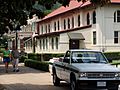
The former Army and Navy General Hospital also received water from the hot springs. It is located behind the south end of Bathhouse Row. This hospital was managed by the War Department. It served military members, Public Health Service officers, and honorably discharged veterans. The hot spring waters were believed to help those with certain illnesses. The hospital accepted cases that were serious and difficult to treat, but where the waters were expected to help with recovery.
The current hospital building was constructed in 1933. After its time as a military hospital, the state of Arkansas used it for over 60 years. It was first the Hot Springs Rehabilitation Center, then the Arkansas Career Training Institute, and finally the Arkansas Career Development Center until May 2019.
After 2019, the building became empty. Its ownership is currently unclear. The building is listed on the National Register of Historic Places as the "Army and Navy General Hospital Historic District."
-
Fordyce Bathhouse
-
Maurice Bathhouse
-
Hale and Superior Bathhouses
-
National Baptist Hotel and Sanitorium (a bathhouse for people of color in the past)
_VC.JPG)


.JPG)
Challenges and Changes Over Time
Like many old cities, Hot Springs faced challenges. In November 1864, during the American Civil War, a large part of the city was burned. Fires were a big risk before modern city services. On March 5, 1878, a huge fire destroyed nearly 150 buildings. Another fire in 1905 burned 25 blocks, and in 1913, a fire spread quickly, burning 50 blocks in the business district.
The city also experienced floods because of its narrow valley. In 1923, a severe rainstorm caused water to rush down the mountains. It flooded Central Avenue, reaching a depth of nine feet. Lightning during this storm also caused a fire. In 1956, another flood filled Central Avenue with three feet of water. In 1990, a series of storms dropped over 13 inches (330 mm) of rain. This caused flash floods, and a six-foot wave of water washed through downtown, causing a lot of damage.
On February 27, 2014, a fire broke out at the Majestic Hotel, just outside the park. Firefighters worked for over 22 hours to put out the blaze. The remaining part of the Majestic Hotel was later demolished in the Fall of 2016. The site was sold to a developer, but as of 2022, the company decided not to continue with the project.
For many years, the government also provided free baths for people who could not afford to pay. The first Government Free Bathhouse opened in 1878. It was a clean building designed to serve many people. In 1916, a clinic opened to examine and treat those taking the free baths. People had to promise they could not afford to pay for baths. By 1957, the free bathhouse closed. It became more practical for the few people needing free baths to use the commercial bathhouses, with the government covering the cost.
Climate and Nature
The climate at Hot Springs National Park is generally warm and humid. It has a Humid subtropical climate. The average lowest temperature in winter is around 9.5°F (-12.5°C).
| Climate data for Hot Springs National Park Visitor Center. Elev: 712 ft (217 m) | |||||||||||||
|---|---|---|---|---|---|---|---|---|---|---|---|---|---|
| Month | Jan | Feb | Mar | Apr | May | Jun | Jul | Aug | Sep | Oct | Nov | Dec | Year |
| Mean daily maximum °F (°C) | 51.4 (10.8) |
56.2 (13.4) |
64.7 (18.2) |
73.6 (23.1) |
80.5 (26.9) |
88.2 (31.2) |
92.9 (33.8) |
93.3 (34.1) |
85.7 (29.8) |
74.8 (23.8) |
62.9 (17.2) |
52.5 (11.4) |
73.1 (22.8) |
| Daily mean °F (°C) | 40.7 (4.8) |
44.6 (7.0) |
52.6 (11.4) |
61.3 (16.3) |
69.5 (20.8) |
77.1 (25.1) |
81.3 (27.4) |
80.9 (27.2) |
73.3 (22.9) |
62.4 (16.9) |
51.7 (10.9) |
42.1 (5.6) |
61.5 (16.4) |
| Mean daily minimum °F (°C) | 29.9 (−1.2) |
33.0 (0.6) |
40.5 (4.7) |
48.9 (9.4) |
58.4 (14.7) |
66.0 (18.9) |
69.7 (20.9) |
68.5 (20.3) |
60.9 (16.1) |
50.0 (10.0) |
40.6 (4.8) |
31.7 (−0.2) |
49.9 (9.9) |
| Average precipitation inches (mm) | 3.56 (90) |
4.13 (105) |
5.18 (132) |
5.01 (127) |
5.86 (149) |
4.40 (112) |
4.40 (112) |
2.81 (71) |
3.78 (96) |
5.31 (135) |
5.45 (138) |
5.14 (131) |
55.03 (1,398) |
| Average relative humidity (%) | 68.1 | 65.4 | 62.6 | 63.2 | 70.8 | 71.6 | 68.9 | 67.0 | 68.5 | 69.0 | 71.8 | 71.9 | 68.2 |
| Average dew point °F (°C) | 31.0 (−0.6) |
33.7 (0.9) |
40.2 (4.6) |
48.7 (9.3) |
59.6 (15.3) |
67.2 (19.6) |
70.1 (21.2) |
68.9 (20.5) |
62.3 (16.8) |
52.1 (11.2) |
42.9 (6.1) |
33.7 (0.9) |
50.9 (10.5) |
| Source: PRISM Climate Group | |||||||||||||
The park is mostly covered in forests. The northern slopes of the mountains have deciduous forests with lots of oak and hickory trees. On the southern slopes, you'll find more Pine trees. There are also special old-growth forests, with some trees over 130 or even 200 years old! These include shortleaf pine, blackjack oak, and white oak.
Long ago, animals like Plains bison, elk, cougar, and red wolf lived here. Today, you might see white-tailed deer, wild turkey, squirrels, rabbits, Virginia opossum, gray fox, coyotes, skunks, raccoons, and nine-banded armadillos. Many migratory birds also visit the area as they follow the Mississippi Flyway.
How the Hot Springs Work: Geology
The hot springs are found in the Ouachita Mountains of central Arkansas. The springs appear in a gap between Hot Springs Mountain and West Mountain. There are 43 thermal springs in the park that are believed to be flowing. The hot water comes from thousands of feet underground. It mixes with some cooler groundwater near the surface.

The water starts as rain that falls on the mountains to the north. It slowly flows downward through cracks in the rocks, about one foot per year. This journey takes the water to depths of about 4,500 to 7,500 feet (1,370 to 2,285 meters). Deep underground, the water gets very hot from the natural heat of the Earth's rocks. Then, it rises back up through cracks and faults. Some rainwater near the surface mixes with this deep hot water before it comes out. The trip down takes about 4,000 years, but the hot water takes only about a year to rise back to the surface!
The heat comes from the Earth's natural warmth as you go deeper underground. There are no volcanoes involved here. The water's makeup shows it's heated rainwater, not from a volcanic source. This process creates a slightly alkaline, pleasant-tasting water with dissolved calcium carbonate. As minerals in the water come to the surface, they form white to tan travertine or "tufa rock" near the spring openings.

What's in the Water?

The water from all the hot springs comes from the same deep source. In the past, different springs had different names, like "Mud Spring" or "Big Iron." Today, the water from many springs is combined into one supply. The total amount of water flowing is about 750,000 to 950,000 US gallons (2.8 to 3.6 million liters) a day. The average temperature is about 143°F (62°C).
The water has a very small, natural level of radioactivity, mainly from dissolved radon gas. This level is considered safe for bathing and drinking. It's similar to the amount of radiation you might get from sitting in the sun for the same amount of time. The park's water is well within safe limits and similar to other natural waters around the world.
You can drink the hot spring water from several public fountains. This hot water is naturally safe to drink. There are also two cold water springs (Happy Hollow and Whittington Springs) that are treated with ozone filtration. It's against park rules for private individuals to sell the park's waters.

| Chemical | Parts per million |
|---|---|
| Bicarbonate (HCO3−) | 130.0 |
| Silica (SiO2) | 53.0 |
| Calcium (Ca2+) | 47.0 |
| Free carbon dioxide (CO2) | 9.7 |
| Sulfate (SO42−) | 7.8 |
| Oxygen (O2) | 4.5 |
| Magnesium (Mg2+) | 4.9 |
| Chloride (Cl−) | 2.2 |
| Sodium (Na+) | 4.0 |
| Potassium (K+) | 1.4 |
| Fluoride (F−) | 0.26 |
See also
 In Spanish: Parque nacional Hot Springs para niños
- List of national parks of the United States
- Niagara Falls State Park - the first state park in the United States
