Memphis to Little Rock Road facts for kids
Quick facts for kids Memphis to Little Rock Road |
|
|---|---|
| Lua error in Module:Infobox_road/map at line 15: attempt to index field 'wikibase' (a nil value). | |
| Route information | |
| Length | 136 mi (218 km) |
| Existed | 1819–present |
| Major junctions | |
| West end | Southwest Trail in Little Rock, AR |
| East end | a point opposite the town of Memphis [across the Mississippi River] |
| Location | |
| States: | Arkansas, Tennessee |
| Highway system | |
| Settlement routes
|
|
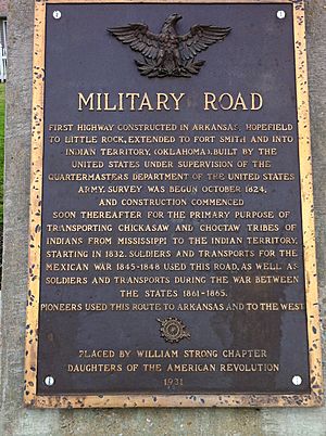
The Memphis to Little Rock Road, also called the Military Road, was an important path built between 1819 and the Reconstruction era in Arkansas. This road was one of many big projects to help people settle the Old Southwest region. It also helped with military defense in the Arkansas Territory.
Contents
History of the Military Road
The city of Memphis was started on May 22, 1819. It was founded by John Overton, James Winchester, and Andrew Jackson. Memphis was in a great spot on the Chickasaw Bluffs, high above the Mississippi River. Because of this, it quickly became a busy center for trade and travel.
As "King Cotton" became very important, the rich land around Memphis became large cotton farms. Memphis grew into a major place for selling cotton. It also became a hub for finding workers for these farms, including many African-American people who were forced to move and work there.
When Arkansas became a territory in 1819, it was mostly wild land with swamps and forests. There were not many towns. The U.S. government believed that a road between Memphis and the new capital, Little Rock, would help the area grow. The government agreed to help on January 31, 1824. They set aside $15,000 (which is like $400,000 today) to map out the road.
Building the Memphis to Little Rock Road

Soon after starting from Memphis, the team of three surveyors found the land was very wet and swampy. Even with disagreements about the best path, they chose a route that was 135.5 miles (218.1 km) long. This cut the travel distance by more than 60 miles (97 km). Before this, people had to travel through Arkansas Post or Helena, Arkansas.
By 1828, the 24 feet (7.3 m) wide dirt road was open. However, it often closed after heavy rains. By 1831, the Arkansas General Assembly asked for $20,000 (about $550,000 today) for repairs. Flooding made the road impossible to use, sometimes for months. This made it hard for people to move to Arkansas and areas further west.
Arkansas now had a voice in the U.S. House of Representatives with Ambrose Sevier. He had the attention of President Andrew Jackson. Studies were done to find out what improvements were needed. This led to an extra $106,000 (about $3,107,000 today) from Congress in 1834. This money was used to build a completely new road, along with bridges, levees, and better drainage. The area cleared for the road was now more than 200 feet (61 m) wide. Trees were cut down on both sides to let sunlight dry the road.
Historic Road Segments: National Register of Historic Places
Five parts of the Memphis to Little Rock Road in Arkansas are listed on the National Register of Historic Places. This means they are important historical sites. Even with arguments about the best path, a route of 135.5 miles (218.1 km) was chosen. This cut the total distance by over 60 miles (97 km) compared to older routes through Arkansas Post or Helena, Arkansas.
Strong's Ferry Segment
|
Memphis to Little Rock Road-Strong's Ferry Segment
|
|
| Lua error in Module:Location_map at line 420: attempt to index field 'wikibase' (a nil value). | |
| Nearest city | Jennette, Arkansas |
|---|---|
| Architect | Strong, William |
| MPS | Cherokee Trail of Tears MPS |
| NRHP reference No. | 12000274 |
| Added to NRHP | May 15, 2012 |
The Memphis to Little Rock Road-Strong's Ferry Segment is one of the best-kept parts of the old road built in 1828. It is in eastern Cross County, Arkansas. This road is special because many pioneers used it to travel west and settle the American Plains. It was also used during the Trail of Tears in the 1830s. This was when several Native American tribes were forced to move from their homes. This part of the road goes from an old ferry crossing on the St. Francis River west towards Village Creek State Park. Another part of the road that you can hike is there.
This road segment was added to the National Register of Historic Places in 2012.
Village Creek Segment
|
Memphis to Little Rock Road-Village Creek Segment
|
|
 |
|
| Lua error in Module:Location_map at line 420: attempt to index field 'wikibase' (a nil value). | |
| Nearest city | Newcastle, Arkansas |
|---|---|
| Area | 10 acres (4.0 ha) |
| Built by | Anderson B. Carr |
| MPS | Cherokee Trail of Tears MPS |
| NRHP reference No. | 03000193 |
| Added to NRHP | April 11, 2003 |
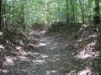
The Memphis to Little Rock Road-Village Creek Segment is a preserved part of the historic military road in Cross County, Arkansas. It is completely inside Village Creek State Park. This 1.5-mile (2.4 km) section of the road is one of the best-preserved parts of the military road built in 1828. Some parts of the road are cut very deeply into the hills. It goes from Village Creek in the east to the western edge of the park. Today, you can hike on this part of the road.
This road segment was added to the National Register of Historic Places in 2003.
Henard Cemetery Road Segment
|
Memphis to Little Rock Road-Henard Cemetery Road Segment
|
|
| Location | Henard Cemetery Rd., Zent, Arkansas |
|---|---|
| Area | 10 acres (4.0 ha) |
| Built by | William Strong |
| MPS | Cherokee Trail of Tears MPS |
| NRHP reference No. | 03000470 |
| Added to NRHP | May 30, 2003 |
The Memphis to Little Rock Road-Henard Cemetery Road Segment is a historic road section in Monroe County, Arkansas. It is 650 metres (2,130 ft) of the middle of Henard Cemetery Road. This is located northeast of Zent. This part of the road is one of three known places where the original look of the first road connecting Memphis, Tennessee to Little Rock, Arkansas is still preserved. The ends of the road have changed due to building and farming. This road is also important because it was used as part of the Trail of Tears. This was the forced movement of Native Americans from east of the Mississippi River to what is now Oklahoma.
This road segment was added to the National Register of Historic Places in 2003.
Brownsville Segment
|
Memphis to Little Rock Road-Brownsville Segment
|
|
| Lua error in Module:Location_map at line 420: attempt to index field 'wikibase' (a nil value). | |
| Nearest city | Brownsville, Arkansas |
|---|---|
| Area | less than one acre |
| Built | 1838 |
| Built by | Samson Gray |
| MPS | Cherokee Trail of Tears MPS |
| NRHP reference No. | 03000954 |
| Added to NRHP | September 27, 2003 |
The Memphis to Little Rock Road-Brownsville Segment is a historic military road section in Lonoke County, Arkansas. It is north of Lonoke near Brownsville. This road section was part of the 1828 Memphis to Little Rock Military Road. It was used in the 1830s during the Trail of Tears. It was also used by soldiers from both sides during the American Civil War, leading up to the Battle of Brownsville.
This road segment was added to the National Register of Historic Places in 2006.
Bayou Two Prairie Segment
|
Memphis to Little Rock Road-Bayou Two Prairie Segment
|
|
| Lua error in Module:Location_map at line 420: attempt to index field 'wikibase' (a nil value). | |
| Nearest city | Brownsville, Arkansas |
|---|---|
| Area | less than one acre |
| Built | 1838 |
| Built by | Samson Gray |
| MPS | Cherokee Trail of Tears MPS |
| NRHP reference No. | 06000836 |
| Added to NRHP | September 20, 2006 |
The Memphis to Little Rock Road-Bayou Two Prairie Segment is another historic military road section in Lonoke County, Arkansas. It is also north of Lonoke near Brownsville. This part of the road was also part of the 1828 Memphis to Little Rock Military Road. It was used in the 1830s during the Trail of Tears. Soldiers from both sides of the American Civil War also used it before the Battle of Brownsville.
This road segment was added to the National Register of Historic Places in 2006.
 | Emma Amos |
 | Edward Mitchell Bannister |
 | Larry D. Alexander |
 | Ernie Barnes |


