Southwest Trail facts for kids
The Southwest Trail was an important path in the 1800s. It was the main way for American settlers to travel to Texas.
Contents
History
What Was the Southwest Trail?
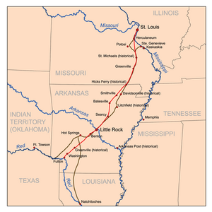
The Southwest Trail was also known as the Old Military Road. It took the place of an older path called the Natchitoches Trace. The Natchitoches Trace went from near St. Louis, Missouri, all the way to Fulton, Arkansas. From Fulton, another path, first used by American Indian people, followed the Red River to Natchitoches, Louisiana.
The Southwest Trail was actually a group of paths. These paths connected places like St. Louis and Ste-Geneviève, Missouri, to the Red River Valley in Texas. As more European American pioneers moved west, they made these older paths better and wider. At that time, the Red River was the border between Mexico and the United States.
How the Trail Grew
Before 1819, when Arkansas became a territory, the Southwest Trail was mostly just a small footpath. But in the 1820s, it became a very busy route for people moving to new lands. By the 1830s, more than 80% of the people living in the Arkansas territory had arrived using the Southwest Trail. The U.S. Army even improved this military road when Andrew Jackson was president.
Later in the 1800s, fewer people used the northern part of the trail (north of the Arkansas River). However, the southern part of the trail stayed in use for many more years.
Route
Where Did the Trail Go?
The Southwest Trail started near St. Louis and Ste-Geneviève in Missouri. It passed through Wayne County, Missouri. This trail was also one of the paths used by the Cherokee people and their enslaved Africans during the sad journey known as the Trail of Tears.
What started as a simple footpath eventually became a series of rough roads. Today, many modern highways follow parts of the original trail.
Key Places Along the Way
The Southwest Trail enters Arkansas north of Maynard (in Randolph County). It then goes through towns like Pocahontas, Imboden, and Strawberry.
Pioneers used two main routes to get to Southside. The older, eastern path went through Davidsonville. Davidsonville was an important town on the Black River. But because of frequent floods, people started using a newer, western path. This path went through Sulphur Rock and crossed the White River at Batesville.
From Southside, the trail followed various roads and highways, including parts of U.S. Route 167 and Arkansas Highway 5. It passed through towns like Floyd and El Paso.
Crossing the Arkansas River
The Southwest Trail crossed the Arkansas River on what is now U.S. Route 70. It went through Little Rock and continued on Arkansas Highway 5 through Bryant and Benton. At Rockport, pioneers had to cross the Ouachita River.
Towards Texas
From Rockport, the trail continued south, following different roads and highways. It went through places like Social Hill, Caddo Valley, and Antoine. It also passed through Blevins and Washington.
Finally, the trail reached Fulton and crossed the Red River on U.S. Route 67. It continued to Mandeville and then west on U.S. Route 82 to Texarkana, which is on the border of Arkansas and Texas today.
The trail is remembered at the Historic Washington State Park, which is northwest of Hope. Washington was a very important trading spot near the end of the Southwest Trail.
 | Delilah Pierce |
 | Gordon Parks |
 | Augusta Savage |
 | Charles Ethan Porter |


