
Ouachita River facts for kids
Quick facts for kids Ouachita River |
|
|---|---|

Ouachita River in Ouachita County, Arkansas
|
|

Map of the Ouachita River watershed. The Ouachita joins the Tensas River near Jonesville, Louisiana to form the Black River (Louisiana).
|
|
| Country | United States |
| State | Arkansas, Louisiana |
| Cities | Hot Springs, Arkansas, Camden, Arkansas, Monroe, Louisiana, West Monroe, Louisiana |
| Physical characteristics | |
| Main source | Ouachita Mountains, Polk County, Arkansas 34°41′56″N 94°19′57″W / 34.69889°N 94.33250°W |
| River mouth | Black River Catahoula Parish, near Jonesville, Louisiana 31°37′53″N 91°48′25″W / 31.63139°N 91.80694°W |
| Length | 605 mi (974 km) |
| Basin features | |
| Tributaries |
|


The Ouachita River (pronounced WAH-shi-tah) is a long river in the United States. It flows for about 605-mile (974 km) through Arkansas and Louisiana. The river eventually joins the Tensas River to form the Black River near Jonesville, Louisiana. It is one of the longest rivers in the United States.
Contents
Exploring the Ouachita River's Path
The Ouachita River starts in the Ouachita Mountains near Mena, Arkansas. It flows east into Lake Ouachita, a large lake formed by the Blakely Mountain Dam. Other streams also join the main river here. Part of the river in this area runs through the Ouachita National Forest.
Lakes and Dams Along the River
From Lake Ouachita, the river flows south into Lake Hamilton. This lake was created by the Carpenter Dam. The city of Hot Springs is located on the north side of Lake Hamilton. Another lake, Lake Catherine, is just below Lake Hamilton. Below Lake Catherine, the river flows freely through much of Arkansas.
River Journey Through Arkansas
Just after Lake Catherine, the river turns south near Malvern. It then meets the Caddo River near Arkadelphia. Further downstream, the Little Missouri River joins the Ouachita. After passing Camden, the river gets deeper for boats to use. Smackover Creek and the Saline River also flow into the Ouachita.
South of the Saline River, the Ouachita flows into Lake Jack Lee. This lake was created as part of a project to help boats travel on the river. The Felsenthal National Wildlife Refuge protects the Ouachita River from the Saline River to Lake Jack Lee.
Ouachita River in Louisiana
Below Lake Jack Lee, the Ouachita continues south into Louisiana. It flows through the state, collecting water from many smaller rivers and bayous. These include Bayou Bartholomew, Bayou de Loutre, Bayou d'Arbonne, the Boeuf River, and the Tensas River.
The Ouachita River has five locks and dams. These structures help boats travel safely along the river by raising or lowering the water level. They are located at Camden, Calion, and Felsenthal, Arkansas. There are also locks and dams in Columbia and Jonesville, Louisiana.
The Black River Connection
The part of the river below where it joins the Tensas River is called the Black River. This section flows for about 41.6 miles (66.9 km) in Catahoula and Concordia parishes. The Black River then joins the Red River, which eventually flows into the Atchafalaya River and the Mississippi River.
History of the Ouachita River
The Ouachita River is named after the Ouachita tribe. They were one of several Native American tribes who lived along the river. Other tribes included the Caddo, Osage Nation, Tensa, Chickasaw, and Choctaw. Some historians believe the name "Ouachita" comes from a Choctaw phrase meaning "good hunting grounds."
Ancient People and Mound Builders
Long before these tribes, ancient people lived along the river for thousands of years. In the Lower Mississippi Valley, they started building large earth mounds. The earliest known mound complex, called Watson Brake, was built around 3500 BC. This was built by hunter-gatherers in what is now Louisiana. This discovery showed that people built mounds long before they settled down to farm.
A very large prehistoric mound near Jonesville, Louisiana was destroyed in the 20th century. It was likely built by the Mississippian culture, which grew around 1000 AD. The Spanish explorer Hernando de Soto saw Native Americans using this mound in 1540. A lightning strike destroyed the temple on the mound that year. The tribe saw this as a bad sign and later left the site.
European Influence and Early Settlers
In the late 1700s, when Spain and France controlled the area, the river was a path for early settlers. People like the self-styled Felipe Enrique Neri, Baron de Bastrop used the river for land deals. His lands later went to Aaron Burr, a former Vice President. Burr saw a chance to make money if there was a war with Spain. He and his group were arrested before they reached the Ouachita.
In the 1830s, many people from New York and other eastern cities came to the Ouachita River Valley. The rich soil and easy access by steamboat made the land very appealing. Developers started large cotton farms, which relied on enslaved labor. Steamboats regularly traveled between Camden, Arkansas and New Orleans. This made it easy to travel to the Ouachita River from anywhere in the east.
One of the people who invested in the area was Meriwether Lewis Randolph. He was the youngest grandson of Thomas Jefferson. He was building a home on the Ouachita River in Clark County, Arkansas, when he died in 1837.
The Ouachita River During the Civil War
Some small battles happened near the Ouachita River during the American Civil War. On September 1, 1863, Union forces crossed from Natchez to Vidalia. They moved towards the lower Ouachita, in the part called the Black River. That night, a Confederate steamboat was captured and destroyed by Union soldiers.
A big project called the "Ouachita-Black Rivers Navigation Project" started in 1902. Its goal was to create a waterway for boats from Camden, Arkansas to Jonesville, Louisiana. When it was finished in 1924, it had six locks and dams. This made the river navigable for 351 miles. Today, fewer large boats use the river for shipping. However, the dams and locks still help with recreation and local water supply.
Nature and Wildlife of the Ouachita River
The Ouachita River is still used for commercial navigation, but less than in the old "steamboat" days. Many small creeks flow into the river, bringing unique native fish like killifish. Fishing is still popular in the river. People catch black bass, white bass, bream, freshwater drum, and gar. Sometimes, there are warnings about mercury in some fish, so people are advised not to eat too much. Fishing for rainbow trout is popular below the dams of Lakes Ouachita, Hamilton, and Catherine near Hot Springs, Arkansas.
The river is used a lot for fun activities like boating and fishing upstream of Camden. For most of its length, the Ouachita is surrounded by thick woods and wetlands. It has beautiful scenery that shows the natural beauty of southwestern Arkansas and northern Louisiana.
Cities Along the Ouachita River
Many towns and cities are located along the Ouachita River:
- Hot Springs, Arkansas
- Malvern, Arkansas
- Arkadelphia, Arkansas
- Camden, Arkansas
- Sterlington, Louisiana
- Monroe, Louisiana
- West Monroe, Louisiana
- Columbia, Louisiana
- Harrisonburg, Louisiana
- Jonesville, Louisiana
Images for kids
-
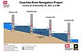
Ouachita River Navigation Project by the U.S. Army Corp of Engineers
-
Flood of 1927 in Arkansas.


See also
 In Spanish: Río Ouachita para niños
