
Lake Ouachita facts for kids
Quick facts for kids Lake Ouachita |
|
|---|---|
.jpg) |
|

Lake Ouachita
Location in Arkansas
|
|
| Location | Garland and Montgomery counties, Arkansas |
| Coordinates | 34°36′N 93°20′W / 34.600°N 93.333°W |
| Type | Hydro-Electric Reservoir |
| Primary inflows | Ouachita River |
| Primary outflows | Ouachita River |
| Basin countries | United States |
| Surface area | 40,000 acres (16,000 ha) |
| Average depth | Avg 50 ft (15 m) |
| Max. depth | 200 ft (61 m) |
| Shore length1 | 690 mi (1,110 km) |
| Frozen | Does not freeze |
| Islands | 200 |
| Settlements | HotSprings |
| 1 Shore length is not a well-defined measure. | |
Lake Ouachita (pronounced WAH-shi-tah) is a huge lake in Arkansas. It was made by building a big wall, called a dam, across the Ouachita River. This dam is known as Blakely Mountain Dam.
Contents
Building Blakely Mountain Dam

The United States Army Corps of Engineers built Blakely Mountain Dam. They worked on it from 1948 to 1953. The dam helps make electricity and provides a fun place for people to visit. It also helps control floods and protects wildlife.
The dam is quite tall, standing 231 feet high. It stretches 1,100 feet across the top. This powerful dam can create 75 megawatts of electricity.
Where is Lake Ouachita?
Lake Ouachita is located near Hot Springs, Arkansas. It is the biggest lake that is completely inside Arkansas. Another large lake, Bull Shoals Lake, is partly in Missouri.
Lake Ouachita has a very long shoreline, stretching over 690 miles (1,110 km). It covers more than 66,324 acres (26,840 ha) of water. The lake is completely surrounded by the beautiful Ouachita National Forest.
This lake is close to two other lakes: Lake Hamilton and Lake Catherine. These three lakes, along with DeGray Lake and the natural hot springs at Hot Springs National Park, make the Hot Springs area a very popular spot for tourists.
Fun Things to Do at the Lake
Lake Ouachita is a great place for fishing! You can catch many types of fish here. Some popular ones include Largemouth Bass, Small Mouth Bass, Spotted Bass, Bream, Crappie, Catfish, and Walleye. It's also famous for its huge Trophy Striped Bass.
Unique Lake Creatures
Lake Ouachita is special because it has rare freshwater jellyfish and sponges. Don't worry, the jellyfish here don't sting! These creatures are found in very few freshwater lakes around the world.
Scuba Diving Adventures
Scuba divers love to explore the underwater world of Lake Ouachita. They come from all over to enjoy diving here. There's even a special season for spear fishing underwater.
Exploring the Lake's Features
The main reasons Lake Ouachita was built were to control floods and produce hydroelectricity. The Army Corps of Engineers created a special path called the Geo-Float Trail. You can follow this marked trail with a brochure that explains the interesting rock formations you see along the way. Lake Ouachita is also home to one of the largest crystal veins in the world!
Taking Care of the Lake's Plants
About 10% of Lake Ouachita is covered by plants. Different groups are working together to manage these plants. These groups include the U.S. Army Corps of Engineers, the Arkansas Game and Fish Commission, and the Lake Ouachita Association.
They are working to control plants like hydrilla and Eurasian watermilfoil. The goal is not to get rid of all the plants. Instead, they want to keep them under control and reduce them. This is because a moderate amount of plants is actually good for the fish in the lake.
They focus on treating areas where people swim, near marinas, and popular boating spots. Areas that are good for fish habitats are usually left alone.
Images for kids
-
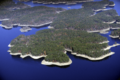
Aerial view of Lake Ouachita, looking towards the West

