Jonesville, Louisiana facts for kids
Quick facts for kids
Jonesville, Louisiana
Troyville
|
|
|---|---|
|
Town
|
|
| Nickname(s):
Bucktown
|
|

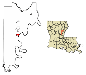
Location of Jonesville in Catahoula Parish, Louisiana.
|
|

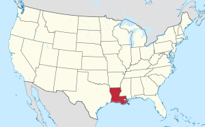
Location of Louisiana in the United States
|
|
| Country | United States |
| State | Louisiana |
| Parish | Catahoula |
| Area | |
| • Total | 1.92 sq mi (4.97 km2) |
| • Land | 1.92 sq mi (4.97 km2) |
| • Water | 0.00 sq mi (0.00 km2) |
| Elevation | 59 ft (18 m) |
| Population
(2020)
|
|
| • Total | 1,728 |
| • Density | 900.00/sq mi (347.55/km2) |
| Time zone | UTC-6 (CST) |
| • Summer (DST) | UTC-5 (CDT) |
| ZIP code |
71343
|
| Area code(s) | 318 |
| FIPS code | 22-38775 |
Jonesville is the biggest town in Catahoula Parish, Louisiana, United States. It's located where three rivers meet: the Ouachita, Tensas, and Little rivers. These three rivers then join to form the Black River right at Jonesville.
In 2010, about 2,265 people lived in Jonesville. By 2020, the population was 1,728.
The four rivers around Jonesville can sometimes flood. The area is surrounded by fields where crops like soybeans and cotton are grown. You can still see some old plantation houses, which were built a long time ago. The town's population dropped quite a bit when a textile factory closed in the late 1980s.
Contents
Exploring Jonesville's Past
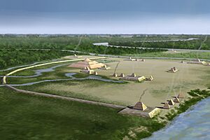
Jonesville was once home to the Troyville Earthworks. These were large mounds built by Native Americans who lived here between 100 BCE and 700 CE. There used to be between 9 and 11 mounds.
Sadly, most of these mounds were flattened to build the modern town. This includes the Great Mound, which was once about 82 feet (25 meters) tall. It was the tallest mound in Louisiana and the second tallest in the United States. It was destroyed in 1931 to help build a bridge. This site is very important for understanding the ancient Troyville culture that lived along the Ouachita and Tensas River valleys.
Geography and Location
Jonesville is bordered by the Little River to the north and the Black River to the east. The Ouachita and Tensas rivers meet to form the Black River just north of the town. Concordia Parish is located across the Black River to the east.
U.S. Route 84 goes through Jonesville as 4th Street. If you go east on this road, you'll reach Ferriday in about 16 miles. Going west, you'll get to Jena in about 23 miles. Louisiana State Highway 124 heads north for about 10 miles to Harrisonburg, which is the main town for Catahoula Parish. Going south on Highway 124, it ends in Argo after about 24 miles.
The United States Census Bureau says that Jonesville covers an area of about 1.92 square miles (5.0 square kilometers), and all of it is land.
Understanding Jonesville's Climate
The weather in Jonesville is known for its hot and humid summers. Winters are usually mild to cool. According to the Köppen Climate Classification system, Jonesville has a humid subtropical climate. This type of climate is often shown as "Cfa" on climate maps.
People of Jonesville
| Historical population | |||
|---|---|---|---|
| Census | Pop. | %± | |
| 1880 | 90 | — | |
| 1890 | 172 | 91.1% | |
| 1910 | 287 | — | |
| 1920 | 1,029 | 258.5% | |
| 1930 | 1,123 | 9.1% | |
| 1940 | 2,080 | 85.2% | |
| 1950 | 1,954 | −6.1% | |
| 1960 | 2,347 | 20.1% | |
| 1970 | 2,761 | 17.6% | |
| 1980 | 2,828 | 2.4% | |
| 1990 | 2,720 | −3.8% | |
| 2000 | 2,469 | −9.2% | |
| 2010 | 2,265 | −8.3% | |
| 2020 | 1,728 | −23.7% | |
| U.S. Decennial Census | |||
As of the 2020 United States census, there were 1,728 people living in Jonesville. There were 703 households and 386 families.
Who Lives in Jonesville?
| Group | Number of People | Percentage |
|---|---|---|
| White (not Hispanic) | 357 | 20.66% |
| Black or African American (not Hispanic) | 1,303 | 75.41% |
| Native American | 4 | 0.23% |
| Asian | 2 | 0.12% |
| Pacific Islander | 1 | 0.06% |
| Other/Mixed | 35 | 2.03% |
| Hispanic or Latino | 26 | 1.5% |
Famous People from Jonesville
- William B. Atkins: He used to be a member of both parts of the Louisiana state government. He lived in Jonesville.
- Charles A. Marvin: He was a district attorney and later a judge for many years. He was born in Jonesville in 1929.
- Tommy McLain: A famous singer-songwriter and musician known for "Swamp-Pop" music. He was born in Jonesville on March 15, 1940.
- Chris Shivers: A former champion bull rider. He lives with his family in Jonesville.
- Jack C. Watson: A lawyer and judge who was born in Jonesville.
See also
 In Spanish: Jonesville (Luisiana) para niños
 | Misty Copeland |
 | Raven Wilkinson |
 | Debra Austin |
 | Aesha Ash |


