Troyville Earthworks facts for kids

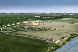
Artists conception of Troyville Earthworks
|
|
| Location | Catahoula Parish, Louisiana, United States |
|---|---|
| Region | Catahoula Parish, Louisiana |
| Coordinates | 31°37′36.59″N 91°48′56.12″W / 31.6268306°N 91.8155889°W |
| History | |
| Founded | 100 BCE |
| Abandoned | 1100 CE |
| Cultures | Baytown culture, Troyville culture-Coles Creek culture |
| Site notes | |
| Excavation dates | 1931-1932, |
| Archaeologists | Winslow Walker |
| Architecture | |
| Architectural styles | platform mounds, plaza |
| Responsible body: private | |
The Troyville Earthworks (also known as 16 CT 7) is an ancient site built by Native Americans. It dates back to a time called the Woodland period, from about 100 BCE to 700 CE. This site was home to people from the Baytown culture and Troyville culture-Coles Creek culture. It is located in Jonesville, Louisiana. The main mound here was once the tallest in Louisiana, reaching 82 feet (25 meters) high! It was even one of the tallest mounds in North America. Sadly, much of it was removed in 1931 to build a bridge.
Contents
What Was the Troyville Earthworks Site Like?
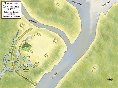
This important archaeological site is found where the Tensas, Ouachita, and Little Rivers meet. Long ago, before 700 CE, the site had nine large platform mounds. It also had a long, raised wall called a perimeter embankment.
In 1844, a historian named John W. Monette described the site. He said it covered almost 400 acres (160 hectares). He also noted there were twelve smaller mounds and one very large one. The perimeter wall was first built during the Middle Baytown period. It was repaired many times over the years.
The Great Mound
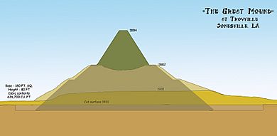
The biggest mound, called Mound 5 or the "Great Mound," was 82 feet (25 meters) tall. This made it the tallest ancient mound in Louisiana. It was also the second tallest in all of North America. The bottom of this mound covered about an acre of land. It had three levels. The bottom two levels were rectangular. The top level was shaped like a cone with a flat top.
Monette described the lowest level of Mound 5 as being 300 feet (91 meters) long and 150 feet (46 meters) wide. It rose about 30 feet (9.1 meters) high. He said the cone-shaped mound on top was 30 feet (9.1 meters) tall. The smaller mounds at the site were about 12 to 20 feet (3.7 to 6.1 meters) high. Their bases were about 150 feet (46 meters) long and 60 feet (18 meters) wide.
Four of the mounds were surrounded by the embankment. This wall was about 10 feet (3.0 meters) high and 10 feet (3.0 meters) wide. It stretched 100 feet (30 meters) across.
Why Did the Mound Shrink?
Over time, the Great Mound became much smaller. By the time of the American Civil War, it was only 50 feet (15 meters) tall. During the war, even more dirt was taken from the mound. It was used to build trenches for soldiers.
In 1871, the town of Jonesville was built on the site. More of the mound's dirt was used to fill in ditches and make the land flat for new buildings. People in the town often camped on the mounds when there was flooding.
In 1883, a famous expert on cultures, Cyrus Thomas, visited the site. He said there were only six mounds left within the embankment. Some of the smaller mounds were almost gone. One mound had even become a modern cemetery. You can still see it today at the local Methodist Church.
The Great Mound had also shrunk more. By this time, it was only 45 feet (14 meters) tall. It was 270 feet (82 meters) long and 180 feet (55 meters) wide. Then, in 1931, the mound became much smaller. Most of its remaining dirt was used to build a nearby bridge. Today, the mound is only about 3 feet (0.91 meters) high.
Exploring the Past at Troyville
The site gets its name from the Troy Plantation. This land was given to John Hebrard in 1786. William Dunbar was the first European to write about the mounds. He mentioned them in his report to Thomas Jefferson in 1804. This was the first written description of an archaeological site in Louisiana.
What Did Archaeologists Find?
In 1931 and 1932, an archaeologist named Winslow Walker from the Smithsonian Institution dug up parts of the site. He found amazing things inside the mound. He discovered woven cane mats, palmetto leaves, and wooden planks. The Native Americans used these materials to build the huge structure.
They created a "cane dome" by layering split cane and dirt. This made the mound very strong. The builders also used different colors of dirt, like blue and red clays. Walker also found a wooden fence, called a palisade, and steps made of tree trunks on one side of the mound. He wrote a 103-page book about his discoveries.
Protecting the Site Today
In the late 2000s, a group called The Archaeological Conservancy started looking into buying parts of the site. This non-profit group wanted to protect the site from being damaged more. The Conservancy bought the land where Mound 4 was located. They tore down the old house there. The group plans to make the site a research preserve. They will landscape and fence it to keep it safe for the future.
 | Precious Adams |
 | Lauren Anderson |
 | Janet Collins |


