
Ouachita County, Arkansas facts for kids
Quick facts for kids
Ouachita County
|
|
|---|---|

Ouachita County Courthouse in Camden
|
|

Location within the U.S. state of Arkansas
|
|
 Arkansas's location within the U.S. |
|
| Country | |
| State | |
| Founded | November 29, 1842 |
| Named for | Ouachita River |
| Seat | Camden |
| Largest city | Camden |
| Area | |
| • Total | 740 sq mi (1,900 km2) |
| • Land | 733 sq mi (1,900 km2) |
| • Water | 7.0 sq mi (18 km2) 0.9%% |
| Population
(2020)
|
|
| • Total | 22,650 |
| • Density | 30.61/sq mi (11.82/km2) |
| Time zone | UTC−6 (Central) |
| • Summer (DST) | UTC−5 (CDT) |
| Congressional district | 4th |
Ouachita County (/ˈwɑːʃɪtɑː/ WAH-shi-tah) is a county located in the south-central part of Arkansas. It's named after the Ouachita River.
As of the 2020 census, about 22,650 people lived here. The main town, or county seat, is Camden. Ouachita County is part of the Camden, AR Micropolitan Statistical Area.
Contents
History
Ouachita County was created on November 29, 1842. For a long time, most people in the county supported the Democratic Party. This was common in the South.
However, over the years, many conservative white voters started to support the Republican Party instead. For example, in 1972, U.S. President Richard M. Nixon was the first Republican president to win the county. Later, in the 2008 presidential election, U.S. Senator John McCain also won the county.
The Pryor family is well-known in Ouachita County. David Pryor and his son Mark Pryor both became U.S. Senators. David Pryor was also a former governor of Arkansas. The county has its own daily newspaper, The Camden News.
Geography

According to the U.S. Census Bureau, Ouachita County covers a total area of 740 square miles. About 733 square miles is land, and 7.0 square miles (0.9%) is water.
Major Highways
 Future Interstate 69
 U.S. Highway 79
 U.S. Highway 278
 Highway 4
 Highway 7
 Highway 9
 Highway 24
Neighboring Counties
- Dallas County (north)
- Calhoun County (east)
- Union County (south)
- Columbia County (southwest)
- Nevada County (west)
- Clark County (northwest)
Population Information
The county had its largest population in 1950.
| Historical population | |||
|---|---|---|---|
| Census | Pop. | %± | |
| 1850 | 9,591 | — | |
| 1860 | 12,936 | 34.9% | |
| 1870 | 12,975 | 0.3% | |
| 1880 | 11,758 | −9.4% | |
| 1890 | 17,033 | 44.9% | |
| 1900 | 20,892 | 22.7% | |
| 1910 | 21,774 | 4.2% | |
| 1920 | 20,636 | −5.2% | |
| 1930 | 29,890 | 44.8% | |
| 1940 | 31,151 | 4.2% | |
| 1950 | 33,051 | 6.1% | |
| 1960 | 31,641 | −4.3% | |
| 1970 | 30,896 | −2.4% | |
| 1980 | 30,541 | −1.1% | |
| 1990 | 30,574 | 0.1% | |
| 2000 | 28,790 | −5.8% | |
| 2010 | 26,120 | −9.3% | |
| 2020 | 22,650 | −13.3% | |
| 2023 (est.) | 21,793 | −16.6% | |
| U.S. Decennial Census 1790–1960 1900–1990 1990–2000 2010 |
|||

This chart shows the population changes over time. The age pyramid shows how many people of different ages live in the county.
2020 Census Details
| Race | Number of People | Percentage |
|---|---|---|
| White (not Hispanic) | 12,092 | 53.39% |
| Black or African American (not Hispanic) | 8,856 | 39.1% |
| Native American | 49 | 0.22% |
| Asian | 123 | 0.54% |
| Pacific Islander | 3 | 0.01% |
| Other/Mixed | 1,011 | 4.46% |
| Hispanic or Latino | 516 | 2.28% |
In 2020, there were 22,650 people living in Ouachita County. There were 9,658 households and 6,009 families.
2010 Census Details
In 2010, there were 26,120 people in the county. The population was made up of 56.3% White, 39.9% Black, 0.3% Native American, and 0.4% Asian people. About 1.6% of the population was Hispanic or Latino.
Communities
Cities
- Bearden
- Camden (county seat)
- Chidester
- East Camden
- Stephens
Town
Census Designated Place
Unincorporated Community
Townships
Townships in Arkansas are the divisions of a county. Each township includes unincorporated areas; some may have incorporated cities or towns within part of their boundaries. Arkansas townships have limited purposes in modern times. However, the United States Census does list Arkansas population based on townships (sometimes referred to as "county subdivisions" or "minor civil divisions"). Townships are also of value for historical purposes in terms of genealogical research. Each town or city is within one or more townships in an Arkansas county based on census maps and publications. The townships of Ouachita County are listed below; listed in parentheses are the cities, towns, and/or census-designated places that are fully or partially inside the township.
Monuments and Memorials
-
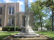
Confederate Women's Monument
-
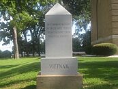
Vietnam Veterans Monument
-
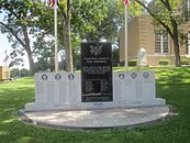
Ouachita County War Memorial


See also
 In Spanish: Condado de Ouachita para niños
