Union County, Arkansas facts for kids
Quick facts for kids
Union County
|
|
|---|---|
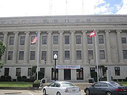
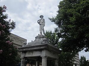
Union County Courthouse in El Dorado
|
|
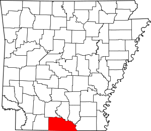
Location within the U.S. state of Arkansas
|
|
 Arkansas's location within the U.S. |
|
| Country | |
| State | |
| Founded | November 2, 1829 |
| Seat | El Dorado |
| Largest city | El Dorado |
| Area | |
| • Total | 1,055 sq mi (2,730 km2) |
| • Land | 1,039 sq mi (2,690 km2) |
| • Water | 16 sq mi (40 km2) 1.5%% |
| Population
(2020)
|
|
| • Total | 39,054 |
| • Density | 40/sq mi (20/km2) |
| Time zone | UTC−6 (Central) |
| • Summer (DST) | UTC−5 (CDT) |
| Congressional district | 4th |
Union County is a place in southern Arkansas, right on the border with Louisiana. In 2020, about 39,054 people lived there. Its main city, or county seat, is El Dorado.
The county was created on November 2, 1829. People wanted a new county and asked for it "in the spirit of Union and Unity." That's how it got its name! Union County is right next to Union Parish in Louisiana.
El Dorado is sometimes called the "Queen City of South Arkansas." It was very important during the 1920s oil boom. Today, it's known as "Arkansas's Original Boomtown." The city focuses on its history to attract visitors. After World War II, chemical and timber industries became very important. They still play a role in the local economy.
Contents
History of Union County
Union County was officially formed on November 2, 1829. It was made from parts of Clark and Hempstead counties. In the early days, areas near rivers were used for cotton farms. These farms relied on enslaved African-American workers.
The Oil Boom Era
On January 10, 1921, Dr. Samuel T. Busey found oil near El Dorado. This discovery started a huge "oil boom." Thousands of workers and people hoping to get rich came to the area.
By 1923, El Dorado had many oil companies. There were fifty-nine companies that helped drill for oil. There were also thirteen companies that sold and cleaned oil. Plus, twenty-two companies produced oil. So many people arrived that there weren't enough beds. Many lived in tents or quickly built shacks.
The city's population grew to almost 30,000 by 1925. After the boom, it dropped to 16,241 by 1930. It then rose to 25,000 by 1960. Oil production slowed down in the early 1930s. This was partly because companies had money problems during the Great Depression. But it got better later in the 1930s.
Industries After World War II
During World War II, chemical factories were built in the county. Their production went down after the war ended. The timber industry also grew as people used Arkansas forests. Today, oil, chemical, and timber industries are still important. However, they are not as big as they once were.
Geography and Nature
Union County covers about 1055 square miles (2,732 square kilometers). Most of this is land, about 1039 square miles (2,691 square kilometers). Only 16 square miles (41 square kilometers) is water. It is the largest county by area in Arkansas.
Union County has the largest amount of bromine in the United States. Bromine is a special chemical element. The lowest point in Arkansas is also in Union County. This spot is on the Ouachita River. It is where the river flows out of Arkansas into Louisiana.
Neighboring Counties and Parishes
Union County shares its borders with several other counties and parishes:
- Ouachita County (to the northwest)
- Calhoun County (to the north)
- Bradley County (to the northeast)
- Ashley County (to the east)
- Morehouse Parish, Louisiana (to the southeast)
- Union Parish, Louisiana (to the south)
- Claiborne Parish, Louisiana (to the southwest)
- Columbia County (to the west)
Protected Natural Areas
Part of the Felsenthal National Wildlife Refuge is located in Union County. This refuge helps protect wildlife and their homes.
Population Changes
| Historical population | |||
|---|---|---|---|
| Census | Pop. | %± | |
| 1830 | 640 | — | |
| 1840 | 2,889 | 351.4% | |
| 1850 | 10,298 | 256.5% | |
| 1860 | 12,288 | 19.3% | |
| 1870 | 10,571 | −14.0% | |
| 1880 | 13,419 | 26.9% | |
| 1890 | 14,977 | 11.6% | |
| 1900 | 22,495 | 50.2% | |
| 1910 | 30,723 | 36.6% | |
| 1920 | 29,691 | −3.4% | |
| 1930 | 55,800 | 87.9% | |
| 1940 | 50,461 | −9.6% | |
| 1950 | 49,686 | −1.5% | |
| 1960 | 49,518 | −0.3% | |
| 1970 | 45,428 | −8.3% | |
| 1980 | 48,573 | 6.9% | |
| 1990 | 46,719 | −3.8% | |
| 2000 | 45,629 | −2.3% | |
| 2010 | 41,639 | −8.7% | |
| 2020 | 39,054 | −6.2% | |
| 2023 (est.) | 37,397 | −10.2% | |
| U.S. Decennial Census 1790–1960 1900–1990 1990–2000 2010 |
|||
Who Lives in Union County?
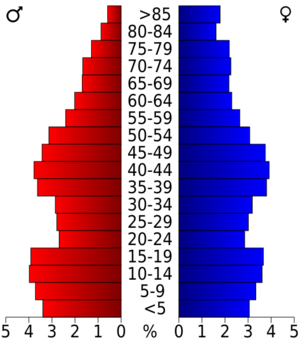
In 2020, there were 39,054 people living in Union County. These people lived in 15,726 homes. About 10,562 of these were families.
Here's a look at the different groups of people in Union County in 2020:
| Group | Number | Percentage |
|---|---|---|
| White (not Hispanic) | 22,904 | 58.65% |
| Black or African American (not Hispanic) | 12,670 | 32.44% |
| Native American | 108 | 0.28% |
| Asian | 273 | 0.7% |
| Pacific Islander | 16 | 0.04% |
| Other/Mixed Race | 1,329 | 3.4% |
| Hispanic or Latino | 1,754 | 4.49% |
Getting Around Union County
Main Roads
You can travel through Union County using these major roads:
 Future Interstate 69
 U.S. Highway 63
 U.S. Highway 82
 U.S. Highway 167
 Highway 7
 Highway 15
 Highway 129
Airport
The main airport in the area is South Arkansas Regional Airport at Goodwin Field.
Towns and Communities
Union County has several cities, towns, and smaller communities.
Cities
- Calion
- El Dorado (This is the county seat, the main city)
- Strong
- Huttig
- Junction City
- Norphlet
- Smackover
Town
Census-Designated Places
These are areas that are like towns but not officially incorporated as cities:
Other Small Communities
- Lapile
- Moro Bay
- Old Union
- New London
- Parkers Chapel
Townships
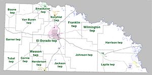
Townships are smaller areas within a county. Here are the townships in Union County:
- Boone
- Cornie
- El Dorado (El Dorado)
- Franklin (Calion)
- Garner
- Harrison
- Henderson (Junction City)
- Jackson
- Johnson
- Lapile (Felsenthal, Huttig, Strong)
- Norphlet (Norphlet)
- Smackover (Smackover)
- Tubal
- Van Buren
- Wesson
- Wilmington
See also
 In Spanish: Condado de Union (Arkansas) para niños
 | Toni Morrison |
 | Barack Obama |
 | Martin Luther King Jr. |
 | Ralph Bunche |


