
Calhoun County, Arkansas facts for kids
Quick facts for kids
Calhoun County
|
|
|---|---|

Calhoun County Courthouse in Hampton
|
|

Location within the U.S. state of Arkansas
|
|
 Arkansas's location within the U.S. |
|
| Country | |
| State | |
| Founded | December 6, 1850 |
| Named for | John C. Calhoun |
| Seat | Hampton |
| Largest city | Hampton |
| Area | |
| • Total | 632 sq mi (1,640 km2) |
| • Land | 629 sq mi (1,630 km2) |
| • Water | 3.8 sq mi (10 km2) 0.6%% |
| Population
(2020)
|
|
| • Total | 4,739 |
| • Density | 7.498/sq mi (2.8952/km2) |
| Time zone | UTC−6 (Central) |
| • Summer (DST) | UTC−5 (CDT) |
| Congressional district | 4th |
Calhoun County is a county located in the south-central part of Arkansas. In 2020, it had 4,739 people, making it the least populated county in Arkansas. The main town and county seat is Hampton.
Calhoun County became Arkansas's 55th county on December 6, 1850. It was named after John C. Calhoun, who was a Vice President of the United States. The county is part of the Camden, AR Micropolitan Statistical Area.
Contents
History of Calhoun County
This area first developed with large farms where enslaved people were forced to work. Before the American Civil War, most people living here were enslaved African Americans. After the Civil War, there were tensions and unfair treatment towards African Americans who had gained their freedom.
In September 1892, a difficult time in the county's history, sometimes called the Hampton Conflict, happened in the southern part of the county. Laws were passed that made it harder for many people, especially African Americans and poor white farmers, to vote. People were facing tough economic times, and tensions were high. Some white people were upset that African Americans, who often had limited choices, would work for lower wages.
Some groups of white farmers, called "Whitecappers," secretly tried to control communities and force African Americans out of jobs. African Americans were very unhappy about these attacks. Newspapers spread rumors, which made the situation even more tense. There was also conflict around the September election.
From the 1900s to Today
Because of social challenges, economic problems, and new farm machines, many African Americans and white people left the county in the early to mid-1900s. The number of people living in the county went down in every census from 1920 to 1970.
Many African Americans moved to cities in the North and Midwest for work before World War II. After the war, many others moved to the West Coast, where there were more jobs in defense factories.
The Shumaker Naval Ammunition Depot, a military facility, operated in Calhoun and Ouachita counties from 1945 to 1957.
Southern Arkansas University Tech is a two-year college in the area. It focuses on technical training.
The Lost 40 Acres of Timber
There is a special area of 40 acres of forest in southeast Calhoun County that has never been cut down. It's along the Wolf Branch, which is a small stream. Some of the huge trees there are more than 200 years old!
Geography
Calhoun County covers a total area of about 632 square miles. Most of this (629 square miles) is land, and a small part (3.8 square miles, or 0.6%) is water.
Main Roads
 Future Interstate 69
 U.S. Highway 79
 U.S. Highway 167
 U.S. Highway 278
 Highway 160
Neighboring Counties
- Dallas County (north)
- Cleveland County (northeast)
- Bradley County (east)
- Union County (south)
- Ouachita County (west)
Population Information
| Historical population | |||
|---|---|---|---|
| Census | Pop. | %± | |
| 1860 | 4,103 | — | |
| 1870 | 3,853 | −6.1% | |
| 1880 | 5,671 | 47.2% | |
| 1890 | 7,267 | 28.1% | |
| 1900 | 8,539 | 17.5% | |
| 1910 | 9,894 | 15.9% | |
| 1920 | 11,807 | 19.3% | |
| 1930 | 9,752 | −17.4% | |
| 1940 | 9,636 | −1.2% | |
| 1950 | 7,132 | −26.0% | |
| 1960 | 5,991 | −16.0% | |
| 1970 | 5,573 | −7.0% | |
| 1980 | 6,079 | 9.1% | |
| 1990 | 5,826 | −4.2% | |
| 2000 | 5,744 | −1.4% | |
| 2010 | 5,368 | −6.5% | |
| 2020 | 4,739 | −11.7% | |
| 2023 (est.) | 4,641 | −13.5% | |
| U.S. Decennial Census 1790–1960 1900–1990 1990–2000 2010–2016 |
|||

2020 Census Details
| Race | Number of People | Percentage |
|---|---|---|
| White (not Hispanic) | 3,499 | 73.83% |
| Black or African American (not Hispanic) | 913 | 19.27% |
| Native American | 3 | 0.06% |
| Asian | 5 | 0.11% |
| Pacific Islander | 9 | 0.19% |
| Other/Mixed | 183 | 3.86% |
| Hispanic or Latino | 127 | 2.68% |
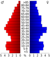
In 2020, there were 4,739 people living in Calhoun County. There were 1,850 households and 1,302 families.
Education
Public schools for kids in elementary and high school are mainly provided by the Hampton School District. Students usually graduate from Hampton High School.
Communities
Cities
Towns
Townships
Calhoun County has numbered townships instead of named ones.
Townships in Arkansas are the divisions of a county. Each township includes unincorporated areas; some may have incorporated cities or towns within part of their boundaries. Arkansas townships have limited purposes in modern times. However, the United States Census does list Arkansas population based on townships (sometimes referred to as "county subdivisions" or "minor civil divisions"). Townships are also of value for historical purposes in terms of genealogical research. Each town or city is within one or more townships in an Arkansas county based on census maps and publications. The townships of Calhoun County are listed below; listed in parentheses are the cities, towns, and/or census-designated places that are fully or partially inside the township.
- Township 1 (Thornton)
- Township 2
- Township 3 (Tinsman)
- Township 4 (Harrell)
- Township 5
- Township 6
- Township 7
- Township 8 (part of Hampton)
- Township 9 (most of Hampton)
Images for kids
-
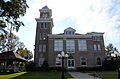
Calhoun County Courthouse in Hampton
-
Age pyramid Calhoun County
See also
 In Spanish: Condado de Calhoun (Arkansas) para niños
