
Cleveland County, Arkansas facts for kids
Quick facts for kids
Cleveland County
|
|
|---|---|
| County of Cleveland | |

Cleveland County courthouse in Rison
|
|

Location within the U.S. state of Arkansas
|
|
 Arkansas's location within the U.S. |
|
| Country | |
| State | |
| Founded | April 17, 1873 |
| Named for | Grover Cleveland |
| Seat | Rison |
| Largest city | Rison |
| Area | |
| • Total | 599 sq mi (1,550 km2) |
| • Land | 598 sq mi (1,550 km2) |
| • Water | 1.0 sq mi (3 km2) 0.2%% |
| Population
(2020)
|
|
| • Total | 7,550 |
| • Estimate
(2023)
|
7,378 |
| • Density | 12.604/sq mi (4.867/km2) |
| Time zone | UTC−6 (Central) |
| • Summer (DST) | UTC−5 (CDT) |
| Congressional district | 4th |
Cleveland County is a county in the state of Arkansas, USA. It used to be called Dorsey County. In 2020, about 7,550 people lived there. The main town and biggest city is Rison. Cleveland County is part of the larger Pine Bluff and Little Rock areas.
Contents
History
Cleveland County was created on April 17, 1873. It was Arkansas's 71st county. It was first named Dorsey County, after Stephen W. Dorsey, who was a U.S. Senator from Arkansas.
Later, Senator Dorsey faced problems because of accusations about his work with the Post Office. Because of this, the county's name was changed on March 5, 1885. It was renamed after Grover Cleveland, who had just become the President of the United States.
A very important battle during the U.S. Civil War happened in what is now Cleveland County. It was called the Battle of Marks' Mills. In this battle, soldiers from the Confederate side won a big victory. However, this win didn't stop the Union Army from escaping to Little Rock later.
Geography
Cleveland County covers about 599 square miles (1,551 square kilometers). Most of this area is land, with only a small part being water.
Major Roads
Many important roads pass through Cleveland County, helping people travel around.
 U.S. Highway 63
 U.S. Highway 79
 U.S. Highway 167
 Highway 8
 Highway 11
 Highway 15 (now US 63)
 Highway 35
 Highway 54
 Highway 97
 Highway 114
 Highway 133
 Highway 189
 Highway 212
Neighboring Counties
Cleveland County shares borders with several other counties:
- Grant County (to the northwest)
- Jefferson County (to the northeast)
- Lincoln County (to the east)
- Drew County (to the southeast)
- Bradley County (to the south)
- Calhoun County (to the southwest)
- Dallas County (to the west)
Population Information
| Historical population | |||
|---|---|---|---|
| Census | Pop. | %± | |
| 1890 | 11,362 | — | |
| 1900 | 11,620 | 2.3% | |
| 1910 | 13,481 | 16.0% | |
| 1920 | 12,260 | −9.1% | |
| 1930 | 12,744 | 3.9% | |
| 1940 | 12,570 | −1.4% | |
| 1950 | 8,956 | −28.8% | |
| 1960 | 6,944 | −22.5% | |
| 1970 | 6,605 | −4.9% | |
| 1980 | 7,868 | 19.1% | |
| 1990 | 7,781 | −1.1% | |
| 2000 | 8,571 | 10.2% | |
| 2010 | 8,689 | 1.4% | |
| 2020 | 7,550 | −13.1% | |
| 2023 (est.) | 7,378 | −15.1% | |
| U.S. Decennial Census 1790–1960 1900–1990 1990–2000 2010 |
|||

2020 Census Details
In 2020, the U.S. census counted 7,550 people living in Cleveland County. There were 3,217 households and 2,254 families. Most people in the county are White (non-Hispanic), making up about 85% of the population. About 9% are Black or African American (non-Hispanic). Other groups, including Native American, Asian, Pacific Islander, and people of mixed races, make up smaller parts of the population. About 2.4% of the population is Hispanic or Latino.
| Race | Number | Percentage |
|---|---|---|
| White (non-Hispanic) | 6,429 | 85.15% |
| Black or African American (non-Hispanic) | 675 | 8.94% |
| Native American | 21 | 0.28% |
| Asian | 7 | 0.09% |
| Pacific Islander | 1 | 0.01% |
| Other/Mixed | 235 | 3.11% |
| Hispanic or Latino | 182 | 2.41% |
Towns and Places
Cleveland County has a few towns and smaller communities.
Cities
Census-Designated Places
These are areas that are like towns but are not officially incorporated as cities.
Education
Several school districts serve the students in Cleveland County:
- Cleveland County School District
- Malvern Special School District
- Star City School District
- Woodlawn School District
Famous People
- Harvey Parnell: He was the 29th governor of Arkansas, serving from 1928 to 1933.
- Tyrell Johnson: He is an American football player who played safety in the NFL. He was born and grew up in Rison.
Images for kids
-
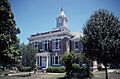
Cleveland County courthouse in Rison
-
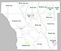
Townships in Cleveland County, Arkansas as of 2010

See also
 In Spanish: Condado de Cleveland (Arkansas) para niños
