
Strong, Arkansas facts for kids
Quick facts for kids
Strong, Arkansas
|
|
|---|---|

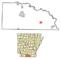
Location of Strong in Union County, Arkansas.
|
|
| Country | United States |
| State | Arkansas |
| County | Union |
| Area | |
| • Total | 1.60 sq mi (4.14 km2) |
| • Land | 1.60 sq mi (4.14 km2) |
| • Water | 0.00 sq mi (0.00 km2) |
| Elevation | 118 ft (36 m) |
| Population
(2020)
|
|
| • Total | 410 |
| • Density | 256.73/sq mi (99.12/km2) |
| Time zone | UTC-6 (Central (CST)) |
| • Summer (DST) | UTC-5 (CDT) |
| ZIP code |
71765
|
| Area code(s) | 870 |
| FIPS code | 05-67370 |
| GNIS feature ID | 2405534 |
Strong is a small city located in Union County, Arkansas, in the United States. It is a quiet community with a rich history. In 2020, the city had a population of 410 people. Strong is known for its local schools and friendly atmosphere.
Contents
About Strong, Arkansas
Strong is a charming city in the southern part of Arkansas. It is a place where people live and work together. The city offers a peaceful environment away from busy city life.
Where is Strong Located?
Strong is found in Union County, which is in the southern part of Arkansas. It is part of the United States. The city is located at specific coordinates: 33°06′28″N 92°21′20″W.
How Big is Strong?
The city of Strong covers a total area of about 1.6 square miles (4.14 square kilometers). All of this area is land, meaning there are no large lakes or rivers within the city limits. This makes Strong a compact and easy-to-navigate place.
Population Changes in Strong
The number of people living in Strong has changed over the years. Like many small towns, its population can go up and down.
How Many People Live in Strong?
The population of Strong was 410 people in 2020. This number comes from the United States Census. The census is a count of all people in the country.
Population History of Strong
Here is a look at how Strong's population has changed over time:
| Historical population | |||
|---|---|---|---|
| Census | Pop. | %± | |
| 1910 | 465 | — | |
| 1920 | 507 | 9.0% | |
| 1930 | 740 | 46.0% | |
| 1940 | 762 | 3.0% | |
| 1950 | 839 | 10.1% | |
| 1960 | 741 | −11.7% | |
| 1970 | 965 | 30.2% | |
| 1980 | 785 | −18.7% | |
| 1990 | 624 | −20.5% | |
| 2000 | 651 | 4.3% | |
| 2010 | 558 | −14.3% | |
| 2020 | 410 | −26.5% | |
| U.S. Decennial Census | |||
As you can see, the population reached its highest point in 1970 with 965 people. It has slowly decreased since then.
Education in Strong
Education is an important part of the Strong community. The city has its own school district.
Strong–Huttig School District
Strong is home to the Strong–Huttig School District. This district serves the students in Strong and the nearby area. The district includes two main schools:
- Gardner–Strong Elementary School
- Strong High School
School District History
The Strong–Huttig School District was formed on July 1, 2004. Before this, there were two separate school districts: the Strong School District and the Huttig School District. They joined together to create the new combined district. This change helped to bring more resources to the students in the area.
Images for kids
-
Location of Strong in Union County, Arkansas.
See also
 In Spanish: Strong (Arkansas) para niños
