Lafe, Arkansas facts for kids
Quick facts for kids
Lafe, Arkansas
|
|
|---|---|

Lafe
|
|

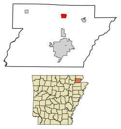
Location of Lafe in Greene County, Arkansas.
|
|
| Country | United States |
| State | Arkansas |
| County | Greene |
| Area | |
| • Total | 2.03 sq mi (5.26 km2) |
| • Land | 2.03 sq mi (5.26 km2) |
| • Water | 0.00 sq mi (0.00 km2) |
| Elevation | 335 ft (102 m) |
| Population
(2020)
|
|
| • Total | 418 |
| • Density | 205.71/sq mi (79.41/km2) |
| Time zone | UTC−06:00 (Central (CST)) |
| • Summer (DST) | UTC−05:00 (CDT) |
| ZIP Code |
72436
|
| Area code(s) | 870 |
| FIPS code | 05-37660 |
| GNIS feature ID | 2405966 |
Lafe is a small town in Greene County, Arkansas, United States. It is located on a raised area of land called Crowley's Ridge. In 2020, about 418 people lived there.
Contents
History of Lafe
Early Settlers and German Immigrants
The first person to settle in Lafe was Herman Toelken. He was an immigrant from Germany. He had been living in New Haven, Missouri, but wanted to find new chances in an undeveloped area.
Toelken started cutting down trees to make railroad ties. He sold these ties to the St. Louis, Iron Mountain and Southern railroad. This helped him earn enough money to buy land. He then sent for his family to join him.
Once Toelken was settled, he placed ads in a German newspaper in Minneapolis. He was looking for other German Lutherans to come to the area. Many families answered his ad. A group of German immigrant families followed him from Franklin County, Missouri.
How Lafe Got Its Name
On December 9, 1889, people wanted to set up a post office in the area. They asked the US Postal Service to call it "Newberry, Arkansas." This name came from a sawmill owner in the area. However, the Postal Service said no to "Newberry."
So, the postmaster at the time combined the names of his daughters. He tried again with the name "Loulyma," and it was accepted. For a while, mail came addressed to "Loulyma." But freight, like goods and supplies, was still sent to "Newberry."
In 1901, a new postmaster named Lafayette Mueller took over. He wanted to make the town's name official and permanent. The people of the town decided to name it "Lafe" to honor him. The name was officially changed on May 21, 1902.
Geography
Lafe is located in a valley near Big Creek. Big Creek flows northwest towards the Black River. The town is on the western side of Crowley's Ridge.
Two main roads meet in Lafe: Highway 135 and Highway 34. Highway 135 goes north about 14 miles to U.S. Route 62 near Corning. It also goes south about 11 miles to Paragould, which is the main city in Greene County. Highway 34 goes east about 8 miles to Marmaduke.
The United States Census Bureau says that Lafe covers a total area of 5.4 square kilometers (about 2.03 square miles). All of this area is land.
Population Information
| Historical population | |||
|---|---|---|---|
| Census | Pop. | %± | |
| 1980 | 215 | — | |
| 1990 | 315 | 46.5% | |
| 2000 | 385 | 22.2% | |
| 2010 | 458 | 19.0% | |
| 2020 | 418 | −8.7% | |
| U.S. Decennial Census | |||
In 2010, there were 458 people living in Lafe. Most of the people (98.0%) were White. A very small number (0.2%) were from other races, and 0.4% were from two or more races. About 1.3% of the population was Hispanic or Latino.
In 2000, there were 385 people living in the town. The population was spread out by age. About 27.5% of the people were under 18 years old. About 8.8% were 65 years old or older. The average age in the town was 34 years.
Education
The Marmaduke School District provides education for students in Lafe. The Lafe School District joined with the Marmaduke district on July 1, 1984.
See also
 In Spanish: Lafe (Arkansas) para niños
 | Leon Lynch |
 | Milton P. Webster |
 | Ferdinand Smith |

