New Haven, Missouri facts for kids
Quick facts for kids
New Haven, Missouri
|
|
|---|---|
 |
|
| Nickname(s):
sun drop country
|
|

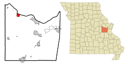
Location of New Haven, Missouri
|
|
| Country | United States |
| State | Missouri |
| County | Franklin |
| Area | |
| • Total | 3.38 sq mi (8.75 km2) |
| • Land | 3.21 sq mi (8.32 km2) |
| • Water | 0.16 sq mi (0.42 km2) |
| Elevation | 669 ft (204 m) |
| Population
(2020)
|
|
| • Total | 2,414 |
| • Density | 751.32/sq mi (290.12/km2) |
| Time zone | UTC-6 (Central (CST)) |
| • Summer (DST) | UTC-5 (CDT) |
| ZIP code |
63068
|
| Area code(s) | 573 |
| FIPS code | 29-51914 |
| GNIS feature ID | 2395200 |
New Haven is a city located in Franklin County, Missouri, in the United States. In 2020, about 2,414 people lived there.
This city is part of the Hermann AVA, which is a special area known for growing grapes and making wine.
Contents
History of New Haven
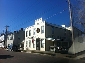
New Haven was first known as Miller's Landing. The city's layout was officially planned in 1855. A post office opened in New Haven in 1858.
Several important places in New Haven are listed on the National Register of Historic Places. This means they are recognized for their historical value. These places include the AME Church of New Haven, the New Haven Commercial Historic District, and the New Haven Residential Historic District. Also listed are the Wilhelm Pelster House-Barn and the Christopher and Johanna Twelker Farm.
A notable person from the New Haven area was Herman Otten. He was a pastor at Trinity Lutheran Church for 55 years. He also worked as an editor for a weekly Christian newspaper called Christian News.
Geography of New Haven
New Haven is located in the northwest part of Franklin County. It sits above the Missouri River Valley. Missouri Route 100 runs along the south side of the city.
The city is about 13 miles northwest of Hermann. It is also about 11 miles east of Washington.
According to the United States Census Bureau, New Haven covers a total area of about 3.45 square miles (8.75 square kilometers). Most of this area, about 3.29 square miles (8.32 square kilometers), is land. The remaining 0.16 square miles (0.42 square kilometers) is water.
Population Changes in New Haven
| Historical population | |||
|---|---|---|---|
| Census | Pop. | %± | |
| 1880 | 471 | — | |
| 1890 | 767 | 62.8% | |
| 1900 | 883 | 15.1% | |
| 1910 | 855 | −3.2% | |
| 1920 | 805 | −5.8% | |
| 1930 | 876 | 8.8% | |
| 1940 | 1,002 | 14.4% | |
| 1950 | 1,009 | 0.7% | |
| 1960 | 1,223 | 21.2% | |
| 1970 | 1,474 | 20.5% | |
| 1980 | 1,581 | 7.3% | |
| 1990 | 1,757 | 11.1% | |
| 2000 | 1,867 | 6.3% | |
| 2010 | 2,089 | 11.9% | |
| 2020 | 2,414 | 15.6% | |
| U.S. Decennial Census | |||
New Haven Population in 2010
In 2010, the city of New Haven had 2,089 people living there. There were 818 households, and 533 of these were families. The city had about 635 people per square mile.
Most of the people living in New Haven were White (95.1%). A small number of residents were African American, Native American, or Asian. Some people identified with two or more races. About 2.1% of the population was Hispanic or Latino.
About 34.8% of households had children under 18 years old. Many households (49.6%) were married couples living together. The average household had 2.45 people. The average family had 3.08 people.
The average age of people in the city was 36.5 years old. About 25.9% of residents were under 18. Another 16.7% were 65 years old or older.
Education in New Haven
The New Haven School District runs the schools in the city. There is one elementary school and one middle school. Students also attend New Haven High School.
New Haven has a public library for its residents. It is part of the Scenic Regional Library system.
See also
 In Spanish: New Haven (Misuri) para niños
 | Roy Wilkins |
 | John Lewis |
 | Linda Carol Brown |

