Black Rock, Arkansas facts for kids
Quick facts for kids
Black Rock, Arkansas
|
|
|---|---|
 |
|

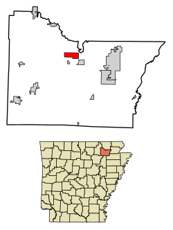
Location in Lawrence County, Arkansas
|
|
| Country | United States |
| State | Arkansas |
| County | Lawrence |
| Area | |
| • Total | 3.42 sq mi (8.86 km2) |
| • Land | 3.29 sq mi (8.51 km2) |
| • Water | 0.14 sq mi (0.35 km2) |
| Elevation | 315 ft (96 m) |
| Population
(2020)
|
|
| • Total | 590 |
| • Density | 179.55/sq mi (69.33/km2) |
| Time zone | UTC-6 (Central (CST)) |
| • Summer (DST) | UTC-5 (CDT) |
| ZIP code |
72415
|
| Area code(s) | 870 |
| FIPS code | 05-06700 |
| GNIS feature ID | 0076368 |
Black Rock is a small city in Lawrence County, Arkansas. It is located right next to the Black River. In 2010, the city had a population of 662 people. By 2020, the population was 590.
Contents
Geography of Black Rock
Black Rock is found in the northern part of Lawrence County. It sits on the western side of the Black River. This river flows south and eventually joins the White River. The city is also located near the eastern edge of the Ozarks mountain range.
Two important roads, U.S. Route 63 and U.S. Route 412, run together through the southern part of Black Rock. These roads connect the city to other towns. For example, U.S. 63 and 412 lead about 30 miles northwest to Hardy. U.S. 412 goes about 9 miles southeast to Walnut Ridge, which is the main town for Lawrence County. U.S. 63 also leads about 8.5 miles to Hoxie.
The city of Black Rock covers a total area of about 3.42 square miles (8.86 square kilometers). Most of this area is land, about 3.29 square miles (8.51 square kilometers). A smaller part, about 0.14 square miles (0.35 square kilometers), is water.
Highways in Black Rock
Several highways pass through or near Black Rock, making it easy to travel to and from the city.
 US 63
US 63 U.S. 412
 Highway 25
 Highway 117
 Highway 361
Population of Black Rock
The number of people living in Black Rock has changed over many years. Here is a look at the population counts from different times:
| Historical population | |||
|---|---|---|---|
| Census | Pop. | %± | |
| 1890 | 761 | — | |
| 1900 | 1,400 | 84.0% | |
| 1910 | 1,078 | −23.0% | |
| 1920 | 835 | −22.5% | |
| 1930 | 751 | −10.1% | |
| 1940 | 769 | 2.4% | |
| 1950 | 662 | −13.9% | |
| 1960 | 554 | −16.3% | |
| 1970 | 498 | −10.1% | |
| 1980 | 848 | 70.3% | |
| 1990 | 736 | −13.2% | |
| 2000 | 717 | −2.6% | |
| 2010 | 662 | −7.7% | |
| 2020 | 590 | −10.9% | |
| U.S. Decennial Census | |||
According to the census from 2000, there were 717 people living in Black Rock. These people lived in 284 households, and 199 of these were families. The average household had about 2.52 people. The average family had about 3.08 people.
About 30.6% of the households had children under 18 living with them. Many households, 56.0%, were married couples living together. About 12.7% of households had someone living alone who was 65 years old or older.
The population was spread out by age. About 27.5% of the people were under 18 years old. About 14.6% were 65 years old or older. The median age in the city was 38 years.
Education in Black Rock
Students in Black Rock attend public schools provided by the Lawrence County School District. This district includes schools like Walnut Ridge Elementary School and Walnut Ridge High School.
Before 2006, Black Rock had its own school district called the Black Rock School District. On July 1, 2006, this district joined with the Walnut Ridge School District. This new, larger district became the Lawrence County School District. The district continued to operate Black Rock Elementary School and Black Rock High School until 2013.
See also
 In Spanish: Black Rock (Arkansas) para niños
 | Leon Lynch |
 | Milton P. Webster |
 | Ferdinand Smith |

