Powhatan, Arkansas facts for kids
Quick facts for kids
Powhatan, Arkansas
|
|
|---|---|

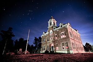
Powhatan Courthouse, located in Powhatan Historic State Park
|
|

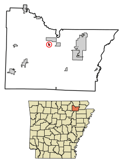
Location in Lawrence County, Arkansas
|
|
| Country | United States |
| State | Arkansas |
| County | Lawrence |
| Area | |
| • Total | 0.55 sq mi (1.42 km2) |
| • Land | 0.55 sq mi (1.42 km2) |
| • Water | 0.00 sq mi (0.00 km2) |
| Elevation | 285 ft (87 m) |
| Population
(2020)
|
|
| • Total | 104 |
| • Density | 190.13/sq mi (73.36/km2) |
| Time zone | UTC-6 (Central (CST)) |
| • Summer (DST) | UTC-5 (CDT) |
| ZIP code |
72458
|
| Area code(s) | 870 |
| FIPS code | 05-57050 |
| GNIS feature ID | 0058422 |
Powhatan is a small town in Lawrence County, Arkansas, United States. It is located right next to the Black River. In 2020, about 104 people lived there.
Contents
Where is Powhatan?
Powhatan is in the northern part of Lawrence County. It is located at coordinates 36.083098 degrees north and 91.119626 degrees west. The town covers a total area of about 0.56 square kilometers (0.22 square miles), and all of it is land.
Getting Around Powhatan
The main road that goes through Powhatan is Arkansas Highway 25 (AR 25). This highway goes northeast for about 2 miles to a town called Black Rock. It also goes southwest for about 48 miles to Batesville.
There's also a shorter road called Highway 117S. It connects to Highway 117 and ends at AR 25 in Powhatan. If you want to get to major east-west routes like US Route 62, US Route 63, and US Route 412, you can find them in Black Rock.
A Look at Powhatan's History
Powhatan was an important place for business in Lawrence County even before it was officially mapped out in 1849. Because it was on the Black River, it was a great spot for river boats and for people to cross the river using a ferry. The Military Road, an old important road, also passed nearby in the 1830s, which helped the local economy grow.
The Civil War (1861-1865) caused problems for trade on the river. After the war, things slowly started to get better. The county government moved to Powhatan from Clover Bend, which helped the town recover.
However, around 1880, a new railway called the Kansas City-Memphis Railway decided to build its tracks around Powhatan instead of through it. This caused a nearby town, Black Rock, to become more important. In 1887, the county decided to have courts in both Powhatan and Walnut Ridge.
Later, in the 1950s, US Route 63 was also changed to go around Powhatan. Finally, in 1963, all county government offices moved to Walnut Ridge.
Population Changes Over Time
The number of people living in Powhatan has changed a lot over the years. Here's a quick look at how the population has grown and shrunk:
| Historical population | |||
|---|---|---|---|
| Census | Pop. | %± | |
| 1880 | 196 | — | |
| 1890 | 220 | 12.2% | |
| 1900 | 249 | 13.2% | |
| 1910 | 191 | −23.3% | |
| 1920 | 134 | −29.8% | |
| 1930 | 110 | −17.9% | |
| 1940 | 137 | 24.5% | |
| 1950 | 120 | −12.4% | |
| 1960 | 136 | 13.3% | |
| 1970 | 84 | −38.2% | |
| 1980 | 49 | −41.7% | |
| 1990 | 51 | 4.1% | |
| 2000 | 50 | −2.0% | |
| 2010 | 72 | 44.0% | |
| 2020 | 104 | 44.4% | |
| U.S. Decennial Census | |||
In the year 2000, there were 50 people living in Powhatan. Most of the people were White. About 38.9% of the homes had children under 18 living there. The average age of people in the town was 42 years old.
See also
 In Spanish: Powhatan (Arkansas) para niños
 | Jessica Watkins |
 | Robert Henry Lawrence Jr. |
 | Mae Jemison |
 | Sian Proctor |
 | Guion Bluford |

