Reyno, Arkansas facts for kids
Quick facts for kids
Reyno, Arkansas
|
|
|---|---|

Reyno
|
|

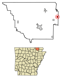
Location of Reyno in Randolph County, Arkansas.
|
|
| Country | United States |
| State | Arkansas |
| County | Randolph |
| Area | |
| • Total | 1.01 sq mi (2.62 km2) |
| • Land | 1.01 sq mi (2.62 km2) |
| • Water | 0.00 sq mi (0.00 km2) |
| Elevation | 282 ft (86 m) |
| Population
(2020)
|
|
| • Total | 391 |
| • Density | 387.13/sq mi (149.42/km2) |
| Time zone | UTC-6 (Central (CST)) |
| • Summer (DST) | UTC-5 (CDT) |
| ZIP code |
72462
|
| Area code(s) | 870 |
| FIPS code | 05-59180 |
| GNIS feature ID | 2404608 |
Reyno is a small city located in Randolph County, Arkansas, in the United States. In 2010, about 456 people lived there. By 2020, the population was 391.
Contents
History of Reyno
Reyno has an interesting history with a few name changes!
Early Names and Location
The town was first called Needmore. It was located a little south of where it is now. Later, the post office from a place called Shoemaker's Ferry moved there. When it did, the town's name changed to Cherokee Bay.
How Reyno Got Its Name
The name changed again to Reyno. This name is a shorter version of "Reynolds." It was named after Dennis Wells Reynolds. He was a merchant who opened the first store and built the first house in the town in 1857.
Moving the Town
In 1901, the town moved to its current spot. This was so it could be closer to the new St. Louis-San Francisco Railway line. When it moved, the new town was briefly called Esselwood. However, most of the people who moved from the old location wanted to keep the name Reyno, so it changed back.
Geography of Reyno
Reyno is located in the northeastern part of Arkansas.
Where is Reyno?
The city's exact location is 36°21′44″N 90°45′17″W / 36.36222°N 90.75472°W. This means it's at 36.362304 degrees North latitude and -90.754772 degrees West longitude.
Land Area
Reyno covers a total area of about 2.6 square kilometers (or 1.0 square mile). All of this area is land, meaning there are no large lakes or rivers within the city limits.
Main Roads in Reyno
Several important highways are near Reyno:
U.S. Highways 62 and 67 run together just southeast of the town.
Population of Reyno
The number of people living in Reyno has changed over the years.
| Historical population | |||
|---|---|---|---|
| Census | Pop. | %± | |
| 1900 | 138 | — | |
| 1910 | 290 | 110.1% | |
| 1920 | 392 | 35.2% | |
| 1930 | 314 | −19.9% | |
| 1940 | 346 | 10.2% | |
| 1950 | 292 | −15.6% | |
| 1960 | 348 | 19.2% | |
| 1970 | 356 | 2.3% | |
| 1980 | 521 | 46.3% | |
| 1990 | 467 | −10.4% | |
| 2000 | 484 | 3.6% | |
| 2010 | 456 | −5.8% | |
| 2020 | 391 | −14.3% | |
| U.S. Decennial Census | |||
People in Reyno
According to the census from 2000, there were 484 people living in Reyno. These people lived in 193 households, and 143 of these were families. The population was spread out, with many young people and older adults.
Education in Reyno
Students in Reyno attend schools that are part of the Corning School District.
School District Changes
Before July 1, 2004, Reyno had its own school district called the Biggers-Reyno School District. This district included Biggers-Reyno High School in Biggers and Biggers-Reyno Elementary School in Reyno. However, on July 1, 2004, the Biggers-Reyno School District joined with the Corning School District. Now, students from Reyno go to schools within the Corning School District.
See also
 In Spanish: Reyno (Arkansas) para niños
 | Georgia Louise Harris Brown |
 | Julian Abele |
 | Norma Merrick Sklarek |
 | William Sidney Pittman |

