Lamar, Missouri facts for kids
Quick facts for kids
Lamar, Missouri
|
|
|---|---|

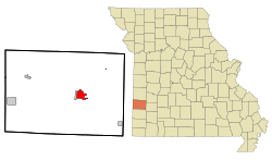
Location of Lamar, Missouri
|
|
| Country | United States |
| State | Missouri |
| County | Barton |
| Area | |
| • Total | 5.53 sq mi (14.32 km2) |
| • Land | 5.21 sq mi (13.51 km2) |
| • Water | 0.31 sq mi (0.81 km2) |
| Elevation | 951 ft (290 m) |
| Population
(2020)
|
|
| • Total | 4,266 |
| • Density | 818.18/sq mi (315.88/km2) |
| Time zone | UTC-6 (Central (CST)) |
| • Summer (DST) | UTC-5 (CDT) |
| ZIP code |
64759
|
| Area code(s) | 417 |
| FIPS code | 29-40376 |
| GNIS feature ID | 2395617 |
| Website | cityoflamar.org |
Lamar is a city in Missouri, United States. It is the main town, or county seat, of Barton County. In 2020, about 4,266 people lived there.
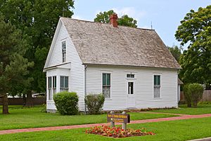
Lamar is famous because it's the birthplace of Harry S. Truman. He was the 33rd President of the United States.
Contents
History of Lamar
Lamar was founded in 1856. It was named after Mirabeau B. Lamar, who was the second President of the Republic of Texas.
During the American Civil War, Lamar faced many attacks from rebel groups.
Geography and Location
Lamar is located at 37°29′37″N 94°16′20″W / 37.49361°N 94.27222°W. The city covers a total area of about 5.43 square miles (14.07 square kilometers). Most of this area is land, with a small part being water.
Population Changes
| Historical population | |||
|---|---|---|---|
| Census | Pop. | %± | |
| 1880 | 907 | — | |
| 1890 | 2,860 | 215.3% | |
| 1900 | 2,737 | −4.3% | |
| 1910 | 2,316 | −15.4% | |
| 1920 | 2,255 | −2.6% | |
| 1930 | 2,381 | 5.6% | |
| 1940 | 2,992 | 25.7% | |
| 1950 | 3,233 | 8.1% | |
| 1960 | 3,608 | 11.6% | |
| 1970 | 3,760 | 4.2% | |
| 1980 | 4,053 | 7.8% | |
| 1990 | 4,168 | 2.8% | |
| 2000 | 4,425 | 6.2% | |
| 2010 | 4,532 | 2.4% | |
| 2020 | 4,266 | −5.9% | |
| U.S. Decennial Census | |||
In 2010, there were 4,532 people living in Lamar. There were 1,866 households, which are groups of people living together.
About 32.5% of households had children under 18. The average age of people in Lamar was 39.6 years.
Getting Around Lamar
The Lamar Municipal Airport (LLU) serves Lamar and nearby towns. It has two runways for planes. One is made of concrete and is 4,000 feet long. The other is asphalt and is 2,900 feet long.
Education in Lamar
The Lamar R-I School District manages public schools in the city. This includes Lamar High School.
Lamar also has a public library. It is a part of the Barton County Library system.
Famous People from Lamar
Many interesting people have connections to Lamar:
- Blaine Durbin — A professional baseball player. He played for teams like the Chicago Cubs.
- Wyatt Earp — A famous lawman from the American frontier. His family also lived here.
- Ed Emery — A politician who served in the Missouri state government.
- Newton T. Enloe — A doctor who started a health system in California.
- Joe Ihm — A politician who served as a state representative in Missouri.
- Charles Henry Morgan — A Missouri congressman who served at different times.
- Henry Carroll Timmonds — A judge and state representative in the late 1800s.
- Harry S. Truman — The 33rd President of the United States. He was born in Lamar. He became president in 1945 after Franklin Delano Roosevelt passed away.
See also
 In Spanish: Lamar (Misuri) para niños
 | John T. Biggers |
 | Thomas Blackshear |
 | Mark Bradford |
 | Beverly Buchanan |


