Zuni-Bandera volcanic field facts for kids
Quick facts for kids Zuni-Bandera Volcanic Field |
|
|---|---|

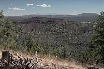
Bandera Crater in the center is part of the Zuni-Bandera lava field.
|
|
| Highest point | |
| Elevation | 8,366 ft (2,550 m) |
| Geography | |
| Location | Cibola County, New Mexico, US |
| Geology | |
| Age of rock | 3.8 million years |
| Mountain type | Volcanic field |
| Last eruption | 1170 BCE ± 300 years |
The Zuni-Bandera volcanic field is a special area in New Mexico, United States, where you can see many signs of old volcanoes. It's also known as the Bandera lava field or Grants Malpais. This field has lots of old volcanoes and lava flows.
People have even thought about using the heat from deep inside the Earth here to make energy. This amazing area is also part of a scenic road called the Trails of the Ancients Byway.
How the Zuni-Bandera Volcanic Field Formed
The Zuni-Bandera volcanic field sits on something called the Jemez Lineament. Imagine this as a deep crack or weak spot in the Earth. This crack goes through the lower part of the Earth's outer shell, called the crust, and the upper part of the layer below it, the mantle.
This weak spot allows melted rock, called magma, to rise from deep inside the Earth. When this magma reaches the surface, it erupts as lava. The lava that came out here was mostly a type of rock called basalt.
Scientists have studied these rocks. They found clues that the magma came from different depths inside the Earth. Not much of the Earth's outer crust mixed into the magma. However, some of the magma changed a bit as it cooled on its way up.
Important Volcanic Vents
A volcanic vent is like an opening in the Earth where lava, ash, and gases can escape. The Zuni-Bandera volcanic field has many of these vents. Some of the most well-known ones are listed below.
| Name | Elevation | Coordinates | Last eruption |
| Cerro Bandera | 2,552 metres (8,373 ft) | 35°00′N 108°06′W / 35.0°N 108.1°W | - |
| Bandera Crater | 2,533 metres (8,310 ft) | 35°00′N 108°05′W / 35.0°N 108.08°W | 9,500-10,900 years ago |
| El Calderon | 2,320 metres (7,612 ft) | 34°58′N 108°01′W / 34.97°N 108.02°W | - |
| Cerro Colorado | - | - | - |
| Cerro Encierro | 2,298 metres (7,539 ft) | 34°53′N 108°03′W / 34.88°N 108.05°W | - |
| Hoyo De Cibola | 2,380 metres (7,808 ft) | 34°53′N 108°07′W / 34.88°N 108.12°W | - |
| Cerro Hueco (Deer Mountain) | 2,441 metres (8,009 ft) | - | - |
| Laguna | - | - | - |
| Lost Woman | 2,459 metres (8,068 ft) | 34°58′N 108°05′W / 34.97°N 108.08°W | - |
| McCarty's Flow | 2,244 metres (7,362 ft) | 35°00′N 107°48′W / 35.0°N 107.8°W | 2,500-3,900 years ago |
| Paxton Springs | 2,490 metres (8,169 ft) | 35°04′N 108°04′W / 35.07°N 108.07°W | - |
| Cerro Rendija | 2,494 metres (8,182 ft) | 34°57′N 108°08′W / 34.95°N 108.13°W | - |
| La Tetra (Cerro Tetra) | 2,458 metres (8,064 ft) | 34°59′N 108°03′W / 34.98°N 108.05°W | - |
| El Tintero | 2,201 metres (7,221 ft) | - | - |
| Twin Craters | 2,423 metres (7,949 ft) | 34°59′N 108°04′W / 34.98°N 108.07°W | 15,800-17,800 years ago |
 | Aaron Henry |
 | T. R. M. Howard |
 | Jesse Jackson |

