
Zuni Pueblo, New Mexico facts for kids
Quick facts for kids
Zuni Pueblo, New Mexico
|
|
|---|---|
.jpg)
Zuni Pueblo in 1945
|
|

Location of Zuni Pueblo, New Mexico
|
|

Zuni Pueblo, New Mexico
Location in the United States

Zuni Pueblo, New Mexico
Location in New Mexico
|
|
| Country | |
| State | |
| County | McKinley |
| Area | |
| • Total | 12.62 sq mi (32.69 km2) |
| • Land | 12.62 sq mi (32.69 km2) |
| • Water | 0.00 sq mi (0.00 km2) |
| Elevation | 6,273 ft (1,912 m) |
| Population
(2020)
|
|
| • Total | 6,176 |
| • Density | 489.27/sq mi (188.91/km2) |
| Time zone | UTC-7 (Mountain (MST)) |
| • Summer (DST) | UTC-6 (MDT) |
| ZIP Code |
87327 (Zuni)
|
| Area code(s) | 505 |
| FIPS code | 35-86595 |
| GNIS feature ID | 2409649 |
Zuni Pueblo, also known as Halona Idiwan’a (which means "Middle Place" in the Zuni language), is a special community in McKinley County, New Mexico, United States. It's a place where many members of the Zuni people live. In 2020, about 6,176 people called Zuni Pueblo home.
Contents
Exploring Zuni Pueblo's Location
Zuni Pueblo is located within the Zuni Indian Reservation in southwestern McKinley County. It's about 37 miles (60 km) south of Gallup and 11 miles (18 km) east of the Arizona border. A smaller community called Black Rock is right next to it on the east.
The main road, New Mexico State Road 53, goes through both Zuni Pueblo and Black Rock. This road can take you to other towns like Ramah or connect you to U.S. Route 191.
Zuni Pueblo covers an area of about 12.6 square miles (32.6 square kilometers), all of it land. The Zuni River flows right through the community. This river travels southwest and eventually joins the Little Colorado River in Arizona.
One very important natural landmark near Zuni Pueblo is Dowa Yalanne. This is a large, flat-topped hill, called a mesa, that covers about 320 acres (130 hectares). It rises up just outside the community to the southeast.
Who Lives in Zuni Pueblo?
The population of Zuni Pueblo has changed over the years. Here's a quick look at how many people have lived there:
| Historical population | |||
|---|---|---|---|
| Census | Pop. | %± | |
| 1950 | 2,563 | — | |
| 1960 | 3,585 | 39.9% | |
| 1970 | 3,958 | 10.4% | |
| 1980 | 5,551 | 40.2% | |
| 1990 | 5,857 | 5.5% | |
| 2000 | 6,367 | 8.7% | |
| 2010 | 6,302 | −1.0% | |
| 2020 | 6,176 | −2.0% | |
| U.S. Decennial Census | |||
Most of the people living in Zuni Pueblo are Native American, mainly members of the Zuni tribe. In 2000, about 6,367 people lived here. Many families in Zuni Pueblo have children under 18. The average household size was about four people. The median age of people living here was 29 years old.
Art, Culture, and Community Life

Zuni Pueblo is a vibrant place known for its rich arts and culture. Many events here are open to visitors, including special religious dances and activities that take place in the Middle Village area.
The community is famous for being an "artist colony." This means many talented artists live and work here. Their main crafts include carving small animal figures from stone, creating beautiful silver jewelry with colorful inlays, and making unique pottery.
You can also find Zuni Pueblo along the Trails of the Ancients Byway. This is a special road in New Mexico that takes you past many important historical and cultural sites.
The Zuni Public Library
The Zuni Public Library has been a part of the community since it opened in 1975. It's a great place for everyone to read and learn!
Learning in Zuni Pueblo
Kids in Zuni Pueblo attend schools run by Zuni Public Schools, which started in 1980. Before that, schools were part of the Gallup-McKinley County Schools. Zuni High School is where older students go for their high school education.
There's also St. Anthony School in Zuni Pueblo, which teaches students from kindergarten through 8th grade. This school opened a long time ago, on September 3, 1923, and was run by the Sisters of Saint Francis.
Getting Around
To help people travel, there's a special transportation service called A:shiwi Transit. It's run by the tribe and connects Zuni Pueblo and Black Rock with the city of Gallup.
-
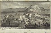
Zuni 1850 illustration
-
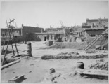
First terrace of Zuni in 1879
-
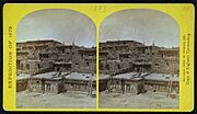
Zuni Pueblo, 1873, by Timothy H. O'Sullivan
-
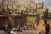
Village Life, Zuni Pueblo, New Mexico


.jpg)
A Glimpse into Zuni History
The Zuni people have a long and rich history. The first time Europeans met the Zuni people was in 1539. This happened at an ancient village called Hawikku. A man named Esteban, who was from Morocco, came to the Zuni lands looking for the legendary "Seven Cities of Cibola." These cities were rumored to be full of gold and riches. Around the same time, an Italian explorer named Marco da Nizza also reached Zuni Pueblo and called it Cibola.
The Ancient Halona Pueblo
|
Halona Pueblo
|
|
|
Location in New Mexico
|
|
| Nearest city | Gallup, New Mexico |
|---|---|
| Area | 1,500 acres (6.1 km2) |
| Built | 1539 |
| NRHP reference No. | 75002066 |
| Added to NRHP | February 10, 1975 |
The Halona Pueblo is another name for Zuni Pueblo. It's located about 36 miles (58 km) south of Gallup, New Mexico. This pueblo existed even before 1539, when Europeans first arrived in New Mexico. It was one of the original six pueblos where the Zuni people lived.
In 1539, an expedition led by Fray Marcos de Niza and Estevan the Moor came to the area. Sadly, some members of their group were killed by the Zunis. A year later, Coronado led another expedition, but they were disappointed because they didn't find the great wealth they expected. Halona Pueblo was recognized as a special historical place and added to the National Register of Historic Places in 1975.
There's also the Old Zuni Mission, called Nuestra Senora de la Candelaria (Our Lady of the Light). It's an important historical building. The Hawikuh Ruins, another National Historic Landmark, are about 12 miles (19 km) away. The Zuni-Cibola Complex, which is also a National Historic Landmark District, was once considered to become a National Park.
See Also
 In Spanish: Zuni Pueblo (Nuevo México) para niños
