
Ramah, New Mexico facts for kids
Quick facts for kids
Ramah, New Mexico
|
|
|---|---|

Ramah Welcome Sign
|
|

Location of Ramah, New Mexico
|
|

Ramah, New Mexico
Location in the United States
|
|
| Country | United States |
| State | New Mexico |
| County | McKinley |
| Area | |
| • Total | 12.27 sq mi (31.77 km2) |
| • Land | 12.27 sq mi (31.77 km2) |
| • Water | 0.00 sq mi (0.00 km2) |
| Elevation | 6,907 ft (2,105 m) |
| Population
(2020)
|
|
| • Total | 461 |
| • Density | 37.58/sq mi (14.51/km2) |
| Time zone | UTC-7 (Mountain (MST)) |
| • Summer (DST) | UTC-6 (MDT) |
| ZIP code |
87321
|
| Area code(s) | 505 |
| FIPS code | 35-61220 |
| GNIS feature ID | 2409127 |

Ramah (Navajo: Tłʼohchiní – place of wild onions) is a small community in McKinley County, New Mexico. It is called a census-designated place (CDP). In 2020, about 461 people lived here. Ramah is known for its beautiful natural surroundings and its interesting history.
Contents
Exploring Ramah's Location
Ramah is located in New Mexico. The area it covers is about 3.8 square miles (9.8 square kilometers). All of this area is land.
The Land Around Ramah
Ramah was founded in 1876 by Mormon pioneers. They were sent by Brigham Young to settle areas in the New Mexico Territory. Ramah was one of about 50 such places, and it is one of only three that still exist today. The pioneers came to do missionary work with the Zuni and Navajo communities. Many of the original stone houses built by these early settlers are still standing. They show how hard the founders worked. One old building has been fixed up and is now a museum. It helps people learn about the valley's past.
The pioneers also built Ramah Lake. This lake helped them farm the land around the town. The area gets a moderate amount of rain each year. The lake's water level depends on snowfall and spring runoff. This is common for many places in New Mexico. In recent years, the lake has sometimes dried up due to drought. When the water was low, the town's irrigation committee improved the lake. They removed a lot of mud and made the dam stronger. This helps them use water more wisely.
Ramah is about 6,926 feet (2,111 meters) above sea level. Some people call it a high desert. But at higher spots, you can find tall pine trees, sandstone cliffs, and mountains covered with timber. Much of the lower land nearby is covered with lava from volcanoes to the south.
Ramah is located between the Zuni Indian Reservation, the Ramah Navajo Indian Reservation, and the Cibola National Forest. Several interesting places are also close to Ramah. These include the Wild Spirit Wolf Sanctuary, El Morro National Monument, and El Malpais National Monument.
People of Ramah
| Historical population | |||
|---|---|---|---|
| Census | Pop. | %± | |
| 2020 | 461 | — | |
| U.S. Decennial Census | |||
In 2020, the population of Ramah was 461 people. The community is made up of different groups of people. In 2000, about 65% of the people were White, and about 26% were Native American. About 7% of the population was Hispanic or Latino.
Many households in Ramah have children. In 2000, over half of the households had children under 18 living with them. The average household had about 3 to 4 people. The median age of people in Ramah was 28 years old. This means half the people were younger than 28 and half were older.
Education in Ramah
The local school district is called Gallup-McKinley County Schools. They run Ramah Elementary School and Ramah Middle/High School in Ramah. Students from the Ramah Navajo Indian Reservation also attend these schools. Even though the reservation is in a different county (Cibola County), students are bused to Ramah schools. This is because the schools in Cibola County are much farther away.
In 1954, a dormitory opened at Ramah Schools. This allowed many students from the Ramah Navajo Indian Reservation to attend public schools close to their homes. The public high school in Ramah Village closed in 1968 because the building was old and there were not enough students. High school students then went to Zuni High School. The dormitory was then only for elementary school students.
A new high school, Ramah Navajo High School, opened in the old Ramah High School building in 1970. In 1975, it moved to Pinehill and became Pine Hill Schools. The Ramah Village public high school reopened in 1983. In 1995, the total number of students in the elementary and high schools in Ramah was less than 400.
Images for kids
-
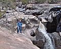
Ramah Falls
-
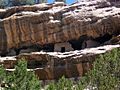
Ancient cliff dwellings in South/East Ramah


See also
 In Spanish: Ramah (Nuevo México) para niños
