
Houck, Arizona facts for kids
Quick facts for kids
Houck, Arizona
|
|
|---|---|

Location in Apache County and the state of Arizona
|
|

Houck, Arizona
Location in the United States
|
|
| Country | United States |
| State | Arizona |
| County | Apache |
| Government | |
| • Type | Navajo Chapter Government |
| Area | |
| • Total | 42.48 sq mi (110.03 km2) |
| • Land | 42.46 sq mi (109.97 km2) |
| • Water | 0.02 sq mi (0.06 km2) |
| Elevation | 5,968 ft (1,819 m) |
| Population
(2020)
|
|
| • Total | 886 |
| • Density | 20.87/sq mi (8.06/km2) |
| Time zone | UTC-7 (MST) |
| ZIP codes |
86506, 86508
|
| Area code | 928 |
| FIPS code | 04-33980 |
| GNIS feature ID | 2408403 |
Houck is a small community in Apache County, Arizona, United States. It is known as a census-designated place (CDP). The Navajo name for Houck is Maʼiitoʼí.
In 2010, about 1,024 people lived in Houck. By 2020, the population was 886.
Contents
Discovering Houck's Past
Houck started thanks to a mail carrier named Houck. He delivered mail between Prescott and Fort Wingate. In 1877, he set up a trading post here. It was called Houck's Tank. He left the area in 1885.
Houck was once a popular stop on U.S. Route 66. It had a fun place called Fort Courage. This was a copy of a set from the 1960s TV show F Troop. Tourists loved to visit it. There was also a bus stop, a gas station, and places to eat. Today, Houck is home to the Native American Baha'i Institute.
Exploring Houck's Geography
Houck is located at 35°17′1″N 109°14′16″W / 35.28361°N 109.23778°W. It covers a total area of about 110 square kilometers (42.5 square miles). Most of this area is land. Only a tiny part, about 0.06 square kilometers (0.02 square miles), is water.
Houck's Climate and Weather
Houck has a semi-arid climate. This means it is usually dry. It gets some rain, but not a lot. This type of climate is often called "BSk" on climate maps.
The weather in Houck can change a lot. Summers are warm, with average high temperatures around 91°F (33°C) in July. Winters are cold, with average low temperatures around 20°F (-7°C) in January. It can get very hot in summer, sometimes over 100°F (38°C). It can also get very cold in winter, dropping below 0°F (-18°C).
Most of the rain falls in July and August. These are the wettest months. The driest month is June.
| Climate data for Houck (6,035 ft above sea level) | |||||||||||||
|---|---|---|---|---|---|---|---|---|---|---|---|---|---|
| Month | Jan | Feb | Mar | Apr | May | Jun | Jul | Aug | Sep | Oct | Nov | Dec | Year |
| Record high °F (°C) | 72 (22) |
74 (23) |
80 (27) |
86 (30) |
96 (36) |
102 (39) |
107 (42) |
101 (38) |
100 (38) |
90 (32) |
79 (26) |
71 (22) |
107 (42) |
| Mean daily maximum °F (°C) | 48 (9) |
53 (12) |
60 (16) |
68 (20) |
78 (26) |
88 (31) |
91 (33) |
88 (31) |
82 (28) |
70 (21) |
58 (14) |
48 (9) |
69 (21) |
| Daily mean °F (°C) | 34 (1) |
38.5 (3.6) |
43.5 (6.4) |
50 (10) |
59 (15) |
68 (20) |
74 (23) |
72.5 (22.5) |
65.5 (18.6) |
54 (12) |
42.5 (5.8) |
34 (1) |
53.0 (11.6) |
| Mean daily minimum °F (°C) | 20 (−7) |
24 (−4) |
27 (−3) |
32 (0) |
40 (4) |
48 (9) |
57 (14) |
57 (14) |
49 (9) |
38 (3) |
27 (−3) |
20 (−7) |
37 (2) |
| Record low °F (°C) | −31 (−35) |
−22 (−30) |
−15 (−26) |
5 (−15) |
14 (−10) |
25 (−4) |
35 (2) |
32 (0) |
20 (−7) |
12 (−11) |
−18 (−28) |
−20 (−29) |
−31 (−35) |
| Average precipitation inches (mm) | 0.86 (22) |
0.69 (18) |
0.84 (21) |
0.60 (15) |
0.52 (13) |
0.23 (5.8) |
1.33 (34) |
1.67 (42) |
1.05 (27) |
1.06 (27) |
0.94 (24) |
0.63 (16) |
10.42 (264.8) |
| Source: Weather Channel | |||||||||||||
People of Houck
| Historical population | |||
|---|---|---|---|
| Census | Pop. | %± | |
| 2000 | 1,087 | — | |
| 2010 | 1,024 | −5.8% | |
| 2020 | 886 | −13.5% | |
| U.S. Decennial Census | |||
In 2000, there were 1,087 people living in Houck. They lived in 312 households. Most of the people in Houck are Native Americans. About 95.6% of the population identified as Native American.
Many households (47.1%) had children under 18 living there. The average household had about 3.5 people. The average family had about 4.2 people.
The population of Houck is quite young. About 42.2% of the people were under 18 years old. The average age was 26 years.
Education in Houck
Students in Houck attend schools in the Sanders Unified School District.
The local schools include Sanders Elementary School and Sanders Middle School. Older students go to Valley High School.
Images for kids
-
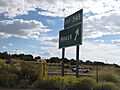
Exit 348 to Houck, Arizona
-
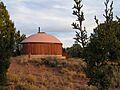
The prayer hogan at the Native American Baha'i Institute on Houck, Arizona, on the Navajo Nation.
-
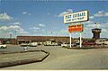
Fort Courage post card, showing the location in the mid-1900s.
-

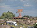
Fort Courage sign in Houck, Arizona
-

Remnants of Fort Courage in Houck, AZ
-
Remnants of Fort Courage in Houck, AZ
-

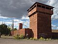
Fort Courage water tower in Houck, AZ
-

Gas station sign behind a building on Fort Courage
-
The remains of a pancake house peaks above the horizon in Houck, AZ
-
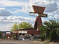
Remains of a building originally built as a Van de Kamp's Dutch Holland Bakery


.jpg)


See also
 In Spanish: Houck (Arizona) para niños
