
Colter Ranch Historic District facts for kids
Quick facts for kids |
|
|
Colter Ranch Historic District
|
|

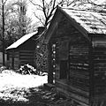
Overview of the district
|
|

Location in Arizona

Location in the United States
|
|
| Nearest city | Eagar, Arizona |
|---|---|
| Area | 73 acres (30 ha) |
| Built by | Phelps, Micajah H.; Colter, Fred T. |
| Architectural style | Vernacular, Folk |
| NRHP reference No. | 93000626 |
| Added to NRHP | July 9, 1993 |
The Colter Ranch Historic District is a special area with twelve old buildings. It's located in a quiet, rural spot near Eagar, Arizona. The Little Colorado River flows right by it. Most of these buildings were built between 1904 and 1930. This was when Fred Colter lived and worked on the ranch.
Contents
What is the Colter Ranch Historic District Like?


Colter Ranch is in a part of Round Valley called Amity Valley. This valley got its name from a Mormon community that was there long ago. The towns of Eagar and Springerville are close by. This area is mostly farmland. Farmers use water from the Little Colorado River to grow their crops.
The historic district has clear boundaries. The Little Colorado River is to the north. 4th Street is to the south. School Bus Road is to the west. The eastern boundary follows a line on a map. A special channel called the Milligan Ditch runs through the district. It brings water from the Little Colorado River to the ranch.
Buildings at Colter Ranch
Most of the buildings are on the south side of the Milligan Ditch. These include three sheds, a log bunkhouse, and a log cabin. There is also a metal shed and a large wooden storage building. This storage building used to be the ranch's store. A wooden machine shop is also in this area. On the north side of the ditch, you'll find a barn, a granary, and a work shed. The work shed is also known as the "little barn."
Oldest Buildings
The oldest building still standing is the log cabin. It was built around 1890. It's about 10 by 15 feet in size. The outside is covered with smooth wooden planks. It has one door facing south. The roof is made of wood shingles and slopes to the sides. There's a fireplace on one side and a small window on the other.
The next oldest buildings were built around 1910. These include the barn, the bunkhouse, a small wooden shed, and the storage building (commissary).
The barn is the biggest building on the ranch. It's 60 feet long and 35 feet wide. It has two stories. Its walls are made of wood boards, and the roof is metal. The barn has two additions. A large fenced area called a corral surrounds the barn. Inside the corral is a granary, built around 1940. It's used to store grain.
The bunkhouse has an entrance on the east side. It was first built with exposed logs. Two additions were made in the 1930s. These additions changed its shape. The smallest shed is west of the bunkhouse. It's about 10 by 10 feet. It has wooden walls and a metal roof.
The commissary building is about 30 feet by 16 feet. It has wooden walls. The front has a door in the middle with two square windows. The other walls have no openings. It has a metal roof.
Newer Buildings
Other buildings were constructed in the 1940s. These include two more sheds. One wooden shed is about 10 by 15 feet. It has a metal roof and wooden walls. It has one door and two small windows. Next to it is a small metal shed. Its walls and roof are made of corrugated metal.
The machine shop is a wooden building. It's about 35 by 25 feet. It has a metal roof. The front has two large wooden doors. Across the ditch, on the north side, is the "little barn." This small work shed is 18 feet by 12 feet. It has a metal roof and unfinished wooden walls.
Two modern homes were built in the 1980s. These homes are not part of the historic value of the site.
History of Colter Ranch

In 1881, a man named Micajah Harris Phelps settled on 160 acres of land. This land was near the newly built Milligan Ditch. He started one of the first large cattle ranches in Round Valley. When he passed away in 1892, his property was divided among his three children. His daughter, Sarah Dugan Phelps (known as Duge), kept the family home in Amity Valley. She managed a large part of her father's cattle herd.
Duge was a very capable and independent woman for her time. She successfully ran her own cattle business for over ten years. In 1904, Duge married Fred Colter. He had been a manager for her brother's cattle operations.
Fred Colter's Ranching Success
Fred Colter had already started his own cattle brand. After marrying Duge in 1904, the homestead became known as the Colter Ranch. He brought his own cattle to the ranch. He also took charge of Duge's large herd. By 1906, he had increased the total herd to over 12,000 animals! Two years later, he built four water reservoirs in the area. He also bought more land to grow food for his livestock.
During this time, Fred Colter built the large barn. It was used to store hay for the animals in winter. He also built a bunkhouse for his many ranch workers. The commissary was built as a store where workers and nearby ranchers could buy supplies. In 1913, a post office was opened at the ranch. It was called the Colter Post Office. Duge was the first and only postmistress. It stayed open until 1922.
By the late 1910s, the ranch was very successful. It had over 43,000 acres of owned land. It also leased over 200,000 acres. It was one of the biggest cattle operations in northern Arizona. It was also the largest ranch in the state that combined cattle farming with irrigated farming.
Changes Over Time
After World War I, prices for grain and beef dropped sharply. To deal with money problems, Colter created a company. But this didn't solve everything. By 1924, banks started taking back parts of the property. By the early 1930s, all the land had been taken.
In 1935, William A. Spence bought the ranch. He moved the commissary building to its current spot. As new farming machines became popular, Spence also built the machine shop.
In 1951, Spence sold 1430 acres of the ranch. This included the Colter Ranch. Later, parts of the ranch were sold to different owners. Famous actor John Wayne even owned a part of the land for a while. Today, Sam Udall, a descendant of one of the earlier owners, still owns the 500 acres that include the historic district.
Images for kids
-
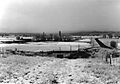
Overview of the district
-
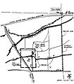
Location of the Colter Ranch Historic District
-
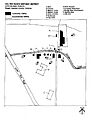
Area plan for the Historic District
-
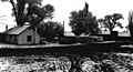
Blacksmith shop, bunkhouse, log cabin, shed, and commissary
-
Log cabin and shed

