Wofford Heights, California facts for kids
Quick facts for kids
Wofford Heights
|
|
|---|---|

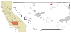
Location in Kern County and the state of California
|
|
| Country | |
| State | |
| County | Kern |
| Area | |
| • Total | 6.40 sq mi (16.58 km2) |
| • Land | 6.40 sq mi (16.58 km2) |
| • Water | 0 sq mi (0 km2) 0% |
| Elevation | 2,684 ft (818 m) |
| Population
(2020)
|
|
| • Total | 2,213 |
| • Density | 345.8/sq mi (133.47/km2) |
| Time zone | UTC-8 (PST) |
| • Summer (DST) | UTC-7 (PDT) |
| ZIP code |
93285
|
| Area codes | 442/760 |
| FIPS code | 06-86174 |
| GNIS feature ID | 1661706 |
Wofford Heights is a small community in Kern County, California. It is located in the southern Sierra Nevada mountains. This area is known as the west Kern River Valley.
Wofford Heights is about 3.5 miles (5.6 km) south-southwest of Kernville. It sits at an elevation of about 2,684 feet (818 m). In 2020, about 2,213 people lived here.
Contents
Exploring Wofford Heights' Location
Wofford Heights is found at these coordinates: 35°42′25″N 118°27′22″W / 35.70694°N 118.45611°W. The main road through the area is California State Route 155. This highway goes south to Lake Isabella. It also heads west through Alta Sierra and the Greenhorn Mountains.
The community covers an area of about 6.4 square miles (17 km2). All of this area is land.
Wofford Heights Climate
Wofford Heights has a semi-arid climate. This means it is often dry. Summers can be very hot, sometimes reaching 113 °F (45 °C). Winters are milder, but temperatures can drop to −3 °F (−19 °C).
The eastern part of Wofford Heights is next to Lake Isabella. You can get to the lake from Wofford Blvd. One way is through the North Fork Marina and Tillie Creek Campground entrance. Another way is at Freear, which is at the end of East Evans Road near Wofford Heights Park.
A Look at Wofford Heights' History
I.L. Wofford started Wofford Heights as a resort in 1948. A post office for the community opened in 1953. The area was even a filming location for a movie called Angels Die Hard in 1970.
In 2016, two large wildfires, the Erskine and Cedar fires, affected the area. These fires burned over 77,000 acres and more than 300 buildings. Because of strong desert winds and the nearby Sequoia National Forest, the Lake Isabella area is considered a high fire risk.
Who Lives in Wofford Heights?
Let's look at the people who call Wofford Heights home.
Population in 2010
In 2010, Wofford Heights had a population of 2,200 people. Most residents were White (92.6%). A small number were Native American (1.9%) or Asian (0.5%). About 7.1% of the people were Hispanic or Latino.
There were 1,143 homes in Wofford Heights. About 15.1% of these homes had children under 18 living in them. Many homes (38.5%) had just one person living there. About 22.3% of homes had someone aged 65 or older living alone. The average home had about 1.92 people.
The community has a lot of older residents. About 37.1% of the population was 65 or older. The average age was 58.3 years old.
Population in 2000
In 2000, there were 2,276 people living in Wofford Heights. The racial makeup was similar to 2010, with most people being White (93.28%). About 6.24% of the population was Hispanic or Latino.
There were 1,162 homes. About 14.3% of these homes had children under 18. Many homes (36.3%) were single-person households. About 21.1% of homes had someone aged 65 or older living alone. The average home had about 1.94 people.
The average age in 2000 was 58 years. About 38.9% of the population was 65 or older.
See also
 In Spanish: Wofford Heights para niños
 | Janet Taylor Pickett |
 | Synthia Saint James |
 | Howardena Pindell |
 | Faith Ringgold |


