
Caliente, California facts for kids
Quick facts for kids
Caliente
|
|
|---|---|
 |
|

Caliente
Location in California

Caliente
Location in the United States
|
|
| Country | |
| State | |
| County | Kern County |
| Elevation | 400 m (1,312 ft) |
| Reference #: | 757 |
Caliente (pronounced Cal-ee-EN-tay) is a small community in Kern County, California. It's called an "unincorporated community" because it doesn't have its own local government. The name "Caliente" means "Hot" in Spanish.
This community is located about 22 miles (35 km) east-southeast of Bakersfield. It sits at an elevation of 1,312 feet (400 meters) above sea level. About 1,019 people live in Caliente. Phone numbers here start with (661) 867-xxxx, and the ZIP Code is 93518.
Contents
History of Caliente
How Caliente Got Its Name
Caliente was first settled in the 1870s. It was originally called Allens Camp. This name came from Gabriel Allen, a cattle rancher who lived there. Later, people thought about calling it Agua Caliente. This name means "Hot Water" in Spanish, referring to some hot springs in the area.
However, there was already another place in California with a similar name. So, when the railroad arrived in 1875, the name was shortened to just Caliente.
The Railroad and Caliente's Growth
Caliente became a busy place when the Southern Pacific Railroad was building its important Tehachapi Pass line. For a while, Caliente was a major hub. The Telegraph Stage Line and the Cerro Gordo Freighting Co. also passed through the town.
During this time, Caliente's population grew to about 200 people. There were around 60 buildings, including many saloons. The Caliente post office first opened in 1875. It closed for a bit but reopened in 1890. The old Caliente General Store was updated in 1980 to become the post office that is still used today.
Bealville and a Historic Landmark
About one mile south of Caliente is a district called Bealville. It's named after Edward Fitzgerald Beale. He was an important person who served in the U.S. Army. He also worked for the government as a Superintendent of Indian Affairs for California and Nevada. Later, he became the U.S. Surveyor General of California.
Beale built a home in this area around 1855. Today, this spot is recognized as California Historical Landmark #757. This landmark tells us more about Caliente's past.
What the Landmark Says
The California Historical Landmark #757 marker reads: NO. 757 CALIENTE - Originally known as Allen's Camp after Gabriel Allen, who in the 1870s had a cabin and stock pasture near here, the settlement was named Caliente when railroad construction reached this point in April 1875. The town became a railroad terminal for about 16 months while a force of up to three thousand men, most of them Chinese, labored on the heavy railroad construction on the mountain.
This means Caliente was a key spot for the railroad for over a year. Thousands of workers, many of them Chinese, worked hard to build the tracks through the mountains.
Caliente Today
Today, the sounds of trains are still a big part of life in Caliente. You can hear diesel locomotives and train horns day and night. The community is right along the Union Pacific Railroad's Mojave Subdivision track. The tracks even loop around the post office as they wind through the local hills.
Trains climb towards the Tehachapi summit if they are going east. They descend toward Bakersfield if they are heading west. California State Route 58 is a main road located about two miles south of Caliente.
Images for kids
-
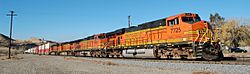
A BNSF freight passing through Caliente climbs eastbound toward Mojave, California.
-
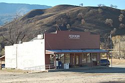
Post office with sign showing the ZIP Code.
-
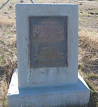
Bealville marker along Caliente-Bodfish Rd.


