Missouri Triangle, California facts for kids
Quick facts for kids
Missouri Triangle
|
|
|---|---|
| Country | United States |
| State | California |
| County | Kern County |
| Elevation | 561 ft (171 m) |
Missouri Triangle is a small, undeveloped area in Kern County, California. It's called an "unincorporated community" because it doesn't have its own local government like a city or town. Instead, it's managed by the county. This area is about 10 miles (16 kilometers) north of a place called McKittrick. It sits at an elevation of 561 feet (171 meters) above sea level.
What is Missouri Triangle?
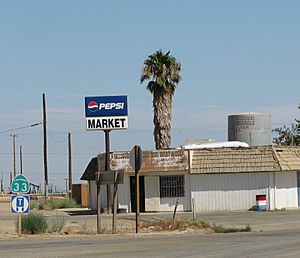
Missouri Triangle gets its name from where three important roads meet. These roads are California State Route 33, Lost Hills Road, and 7th Standard Road. They form a shape that looks like a triangle. This whole area is located inside the South Belridge Oil Field. This means there are many oil wells around.
What You Can Find There
Inside the triangle formed by these roads, you'll find a few things. There's a small mini-mart where people can buy snacks or drinks. You'll also see a water tower. The name "Missouri Triangle" is painted right on this water tower.
Oil Production in the Area
The Missouri Triangle area is part of a very active oil field. An energy company called Aera Energy LLC operates most of the oil wells nearby. These wells help to bring oil out of the ground. This oil is then used to make gasoline and other important products.
 | Shirley Ann Jackson |
 | Garett Morgan |
 | J. Ernest Wilkins Jr. |
 | Elijah McCoy |


