Taft Heights, California facts for kids
Quick facts for kids
Taft Heights
|
|
|---|---|

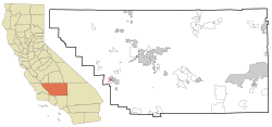
Location in Kern County and the state of California
|
|
| Country | |
| State | |
| County | Kern |
| Area | |
| • Total | 0.303 sq mi (0.785 km2) |
| • Land | 0.303 sq mi (0.785 km2) |
| • Water | 0 sq mi (0 km2) 0% |
| Elevation | 1,178 ft (359 m) |
| Population
(2010)
|
|
| • Total | 1,949 |
| • Density | 6,432/sq mi (2,482.8/km2) |
| Time zone | UTC-8 (PST) |
| • Summer (DST) | UTC-7 (PDT) |
| ZIP code |
93268
|
| Area code(s) | 661 |
| FIPS code | 06-77588 |
| GNIS feature ID | 1661544 |
Taft Heights is a community in Kern County, California, United States. It used to be called Boust City. This area is known as a census-designated place (CDP). This means it's a special area that the government counts for population, but it's not an officially incorporated city or town. Taft Heights is about 1 mile (1.6 km) west-southwest of the city of Taft. It sits at an elevation of 1,178 feet (359 meters) above sea level. In 2010, the population of Taft Heights was 1,949 people. This was a small increase from the 1,865 people counted in 2000.
Geography
Taft Heights is located at coordinates 35°08′05″N 119°28′21″W. The United States Census Bureau says that the total area of Taft Heights is about 0.3 square miles (0.78 square kilometers). All of this area is land, meaning there are no large bodies of water like lakes or rivers within its boundaries.
History
The community of Taft Heights was originally named Boust City. It was given this name to honor E.J. Boust. He was an oilman who played a big part in founding the town.
Population Information
The government collects information about people living in different areas through a process called a census. This helps us understand how communities are growing and changing.
2010 Census Data
According to the 2010 census, Taft Heights had a population of 1,949 people. This means there were about 6,430 people living in every square mile (2,483 people per square kilometer).
Most of the people in Taft Heights were White, making up about 82.2% of the population. About 11.3% of the people were from other races. People who identified as Hispanic or Latino made up about 22.6% of the population.
There were 674 households in Taft Heights. A household is a group of people living together in one home.
- About 44% of these households had children under 18 living there.
- The average household had about 2.89 people.
- The average family had about 3.32 people.
The census also looked at the ages of people living in Taft Heights:
- About 30.2% of the population was under 18 years old.
- About 13.3% was between 18 and 24 years old.
- About 24.4% was between 25 and 44 years old.
- About 23.1% was between 45 and 64 years old.
- About 8.9% was 65 years old or older.
The average age of people in Taft Heights was 29.3 years.
There were 776 housing units in the area. A housing unit is a house, apartment, or other place where people live.
- About 51.2% of the homes were owned by the people living in them.
- About 48.8% of the homes were rented.
2000 Census Data
In the census of 2000, Taft Heights had a population of 1,865 people. The population density was about 6,123 people per square mile (2,364 people per square kilometer).
- About 31.8% of the population was under 18 years old.
- About 10.0% was between 18 and 24 years old.
- About 27.6% was between 25 and 44 years old.
- About 18.8% was between 45 and 64 years old.
- About 11.8% was 65 years old or older.
The average age was 30 years.
See also
 In Spanish: Taft Heights para niños
 | Misty Copeland |
 | Raven Wilkinson |
 | Debra Austin |
 | Aesha Ash |


