
Mount Pinos facts for kids
Quick facts for kids Mount Pinos |
|
|---|---|

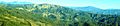
Summit of Mount Pinos; view from the east-southeast
|
|
| Highest point | |
| Elevation | 8,847 ft (2,697 m) NAVD 88 |
| Prominence | 4,800 ft (1,463 m) |
| Listing | California county high points 22nd |
| Geography | |

Mount Pinos
Location in California
|
|
| Location | Kern / Ventura counties, California, U.S. |
| Parent range | Transverse Ranges |
| Topo map | USGS Sawmill Mountain |
| Climbing | |
| Easiest route | Road hike |
Mount Pinos (called 'Iwɨhɨnmu by the Chumash people) is a tall mountain in California. It is found in the Los Padres National Forest, right on the border between Ventura and Kern counties.
The top of Mount Pinos is about 8,847 feet (2,697 meters) high. This makes it the highest point in Ventura County. It is also the tallest mountain in the Transverse Ranges west of Tejon Pass. The mountain was named "Pinos" because of its many pine trees. "Pinos" means "pine" in Spanish.
Contents
Exploring Mount Pinos
The very top of Mount Pinos is quite flat and open. It has a few smaller peaks nearby. You'll see open groups of pine trees mixed with chaparral shrubs.
On a clear day, you can see a lot from the summit! You can spot the southern Central Valley and the southern Sierra Nevada mountains. You can also see much of northern Ventura County and the mountains in Santa Barbara County. The San Andreas Fault, a famous crack in the Earth, is also visible to the northwest.
The lights of nearby cities like Bakersfield can be seen at night.
What Mount Pinos is Made Of
Mount Pinos is mostly made of strong, hard rocks called granite. These rocks are part of something called the "Salinian Block." This is different from the nearby San Emigdio Mountains, which are made of older, changed rocks or younger sedimentary rocks. Because of this, Mount Pinos is seen as a separate geological feature.
Nearby Towns
Small towns are located near Mount Pinos. The community of Pine Mountain Club is just north of the mountain. Lake of the Woods and Frazier Park are about 10 miles (16 km) to the east.
Weather at Mount Pinos
The top of Mount Pinos has cold winters, especially compared to most of Southern California. Most of the rain and snow falls in winter. The area gets several feet of snow each year. Snow can stay on the north-facing slopes until early June, or even later in years with lots of snow.
Winter temperatures often drop to near freezing. They can even go well below zero degrees Fahrenheit in the coldest months.
Summer months are mild and pleasant. High temperatures are usually between 70°F (21°C) and 80°F (27°C). Sometimes, the mountain gets thunderstorms that can bring heavy rain.
Animals and Plants
Plants of Mount Pinos
The types of plants you can find on Mount Pinos include:
Animals of Mount Pinos
Mount Pinos is a very important home for many birds of prey in California. You might see five different kinds of owls here. There are also Northern Goshawks and even California Condors.
Other cool birds living here include the mountain quail, Clark's nutcracker, and Steller's jay. You might also spot a pygmy nuthatch or a green-tailed towhee.
Mount Pinos and the Chumash People
For the Chumash peoples, Mount Pinos (or 'Iwɨhɨnmu) is a very special place. They believe it is the center of the world, a place where everything is in balance. The mountain's summit is the highest in the area and is near the middle of traditional Chumash lands.
For a long time, Chumash people have used the peak for ceremonies, prayers, and offerings. These important traditions are still practiced by Chumash people today.
Hiking on the Mountain
You can reach the top of Mount Pinos by hiking about 2 miles (3.2 km) along a dirt road. This road starts from a parking area at the end of Los Padres National Forest Road S349S.
The trail continues west into the Chumash Wilderness. It ends at Mount Abel (Cerro Noroeste). Almost all of this 6-mile (9.7 km) trail is above 8,000 feet (2,438 meters) in elevation.
Winter Fun and Snow Sports

Mount Pinos often has good snow conditions, making it a great place for winter activities. You can enjoy Backcountry skiing, cross-country skiing, telemark skiing, snowshoeing, snowboarding, sledding, and even snow camping.
There are many ski trails and backcountry areas for skiing and snowboarding. These are shown on local maps. The ski trails are part of a recreation area managed by the United States Forest Service and the Southern California Nordic Ski Patrol. The patrol runs the Nordic Base facility on winter weekends. It is located at the top of Mount Pinos Road, next to the Chula Vista parking lot.
From the Chula Vista parking lot, trails go uphill towards Condor Point and downhill to McGill Campground. You can also ski and snowboard in the backcountry areas on the north side of the peak. Popular spots include Condor Point, 1st and 2nd Meadows, and Inspiration Point.
Sometimes, after heavy snow, the road to the top of Mount Pinos might be closed. But you can still ski from lower down the mountain.
It's important to know that some of these trails need enough snow to be used for skiing. In the summer, these are not marked hiking trails. The Forest Service has a separate map for summer hiking.
Stargazing at Mount Pinos

Mount Pinos is known as one of the best places in Southern California to look at the stars. This is because it has very little light pollution, dry air, and often clear skies. Many amateur astronomers gather here to enjoy the night sky.
The best place for stargazing is usually the large parking area at Chula Vista Campground. This spot is surrounded by trees and is at the end of the paved road, about two miles east of the peak.

- United States Forest Service interpretive plaque near the summit of Mount Pinos
Images for kids
-
Aerial view, Big Pine Mountain region
