
Soda Lake (San Luis Obispo County) facts for kids
Quick facts for kids Soda Lake |
|
|---|---|
 |
|

Soda Lake
Location in California
|
|
| Location | Carrizo Plain National Monument, San Luis Obispo County, California, US |
| Coordinates | 35°13′52″N 119°53′18″W / 35.2312°N 119.8883°W |
| Type | alkali lake |
| Basin countries | United States |
| Surface area | 12 km2 (4.6 sq mi) |
| Surface elevation | 580 m (1,900 ft) |
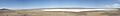
Soda Lake is a special lake in the Carrizo Plain in California. It's a shallow lake that often dries up, especially in summer. This makes it an ephemeral lake. It's also an alkali lake, which means its water is very salty and has a high pH, like baking soda.
Soda Lake is located in southeastern San Luis Obispo County, California. It's about 103 km (64 mi) east of the city of San Luis Obispo. You can get there by taking Soda Lake Road. The lake sits at an elevation of 580 m (1,900 ft) and covers an area of about 12 km2 (4.6 sq mi) when it's full.
Contents
What is an Endorheic Basin?

Soda Lake is part of an endorheic basin. This is a fancy way of saying it's a closed system. Water flows into the lake from the surrounding land, but it doesn't flow out to rivers or the ocean. Instead, the water leaves only by evaporating into the air.
Long, long ago, during the Pliocene and Pleistocene periods, this area was much wetter. A stream used to flow out of the valley. But over time, the movement of Earth's plates (called plate tectonics) created the San Andreas Fault. This fault changed the land, blocking the stream's path. The valley then became a closed basin.
At first, the lake probably had fresh or slightly salty water. But as the climate became drier, especially in the Holocene period, more water evaporated. This made the lake much saltier.
How Water Fills Soda Lake
About 30% of the water that flows into Soda Lake comes from the north. The other 70% comes from the south. The Soda Lake area isn't just one big lake. It's a complex system with two larger basins and more than 130 smaller pools. The main northern basin is shaped like an "L" and covers about 10.5 square kilometers. The other basins cover about 4.8 square kilometers.
The amount of water in these basins changes with the seasons. The Carrizo Plain usually gets only about 20 cm of rain each year. However, the mountains around it get more rain. After very wet winters, especially during El Niño years, the large northern and southern basins might not dry up completely. Even then, the water shrinks toward the center, leaving behind a thick layer of salt up to 20 cm deep.
Wildlife and Habitat
Soda Lake is a very important natural wetland in California. Even though it's salty, it supports a lot of life. Tiny creatures like fairy shrimp and brine shrimp live in its waters. These shrimp are a food source for many birds.
The lake is a crucial stop for migratory birds. Many different kinds of birds visit Soda Lake during their long journeys. Some birds also choose to nest and raise their young here. To help protect the plants and animals around the lake, a boardwalk was built along the shore. This helps visitors explore without damaging the sensitive saltbush habitat that grows near the water.
Amazing Dunes Around the Lake

One of the most interesting features of Soda Lake is the large dune that borders its eastern and southern edges. This dune is huge! It can be up to 470 meters wide, 16.7 meters high, and nearly 9.5 kilometers long.
Part of this dune is still "active." This means it's still growing as wind blows sand and mud from the dry lakebed onto it. The eastern part of the dune, which is a bit smaller, is not active anymore. As the lake's edge moved westward and dried up, salt-resistant plants started to grow. These plants helped to hold the sand in place, stopping the dune from growing further in that area.
Images for kids
-
Panoramic view of Soda Lake
